-
Posts
47,183 -
Joined
Content Type
Profiles
Blogs
Forums
American Weather
Media Demo
Store
Gallery
Everything posted by Hoosier
-
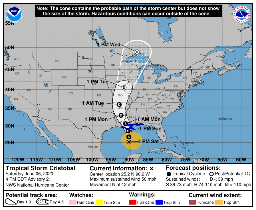
From what I can tell, there has only been one tropical system that landfalled in Louisiana or east of there and passed to the west of Chicago -- a tropical storm in 1906 that made landfall in the Florida panhandle. Sometimes it gets difficult to track the remnant lows as they dissipate, so I can't rule out some additional occurrences, but even if it's a few times, that is pretty rare since the tropical records go back over 150 years.
-
Having the entire cone to my west for a system making landfall on the Gulf coast is certainly not something that happens often
-
And in June of all months. Not Sep/Oct when you would think it would be more likely. Assuming it unfolds reasonably close to what's progged, I don't think it's inaccurate to call this setup unprecedented for the region and time of year, at least as far back as weather records go.
-
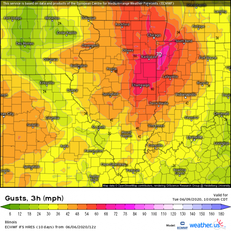
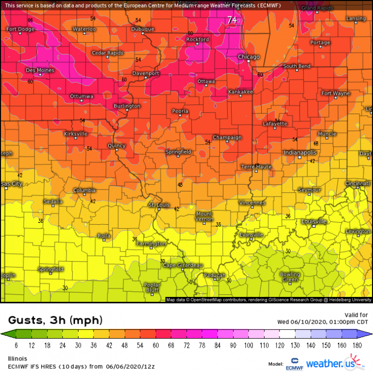
At least with traditional non tropical cyclones, there is usually a question about how well you will mix on the warm side. The second map (Wednesday) would likely be in a deeper mixed environment though.
-
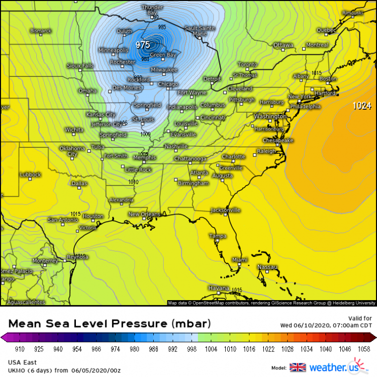
Euro goes sub 980 mb
-
It would be something to see the heaviest rains go west of Cedar Rapids. This is anecdotal but imo, these remnant systems tend to tick farther east than progged at this range as they get into the mid latitudes. No guarantees that happens this time though.
-
We'll see what the 12z Euro has but generally speaking, it and the UKMET have been stronger with the remnants of Cristobal as it enters the Midwest (especially the UK). That of course affects the strength of the wind fields.
-
This is such a bizarre setup for June.
-
GFS trending toward the Euro. We have said that a few times before.
-
Northern Michigan office's take Area Forecast Discussion National Weather Service Gaylord MI 248 AM EDT Sat Jun 6 2020 High impact weather potential: Possible extratropical remnants of Cristobal. Record/near-record high temps Tuesday? As was alluded to by the prior forecaster, quite the complex and challenging forecast expected through the midweek time frame as TS Cristobal is expected to undergo extratropical transition and trek northeastward along the Mississippi Valley into the western Great Lakes. Lots of uncertainty with regards to specific impacts locally as they hinge greatly on the timing of Cristobal and the progression/interaction of impressive troughing expected to be draped across the Intermountain West at the start of the forecast period. Latest NHC forecast has Cristobal making landfall along the Gulf Coast late Sunday/Sunday night, moving into the mid-Mississippi Valley Tuesday before treking further north into the western Great Lakes Tuesday night-Wednesday. Latest guidance continues to suggest that after Cristobal undergoes its extratropical transition and potential interaction with aforementioned troughing that impressive dynamic upper-level forcing would further deepen the cyclone as it treks northward. If this sequence were to pan out as currently progged, certainly the threat for heavy rain and potentially strong winds would present themselves somewhere across the mid-upper Mississippi Valley/Great Lakes. However, as was alluded to above, lots of uncertainties prevail through this time frame. The most glaring is the exceedingly rare nature of this event (in the manner it`s currently progged), along with how well guidance is handling a large influx of latent heat into the ridge across the midsection of NOAM. As the prior forecaster mentioned, if guidance is underdone in this respect, you`d expect this to further amplify the ridge and slow the progression of the aforementioned trough leading to less interaction with Cristobal and a weaker remnant cyclone overall. All in all, lots of variables at play over the next several days, but at the very least, the threat for a potentially impactful storm system is possible across parts of the Great Lakes by the middle of next week.
-
1-2 punch The thing is that the trees would get blasted for hours from multiple directions in this scenario... first from the S/SE and then from the W. Our trees don't have a lot of experience with that when they are fully leafed.
-
Euro and some of the other guidance has the system holding together remarkably well even way after landfall.
-
I wish pivotal still had Euro soundings that you didn't have to sign up for. Would love to check those out.
-
In a way, the "botched phase" ala Euro is still a pretty significant wind threat because of the secondary low that develops with the trailing energy. Prolongs the departure of everything and keeps the wind threat going longer.
-
The 1900 Galveston hurricane was a northward version of Ike. Instead of the swath of damaging winds in the Ohio Valley, it was more in the Lakes in 1900. Reading the old accounts, there was significant tree damage and some minor structural damage in and around northern IL. It can happen, but it's very hard to get a system to track far enough north to put northeast IL on the right side of it. It looks like that could happen with this one, so then it comes down to details of the phasing with the trough and the wind fields.
-
If anyone wants to take a stroll down memory lane, here's a thread I made for Ike: Almost 4 million power outages in the Ohio Valley
-
Euro gust product has 50-60+ mph sweeping through, even in this scenario that has problems with phasing.
-
Yeah, that is a less than pristine interaction. If we get the big phase, katy bar the door. Even so, Euro is still pretty respectable as far as tropical remnants go.
-
Yeah I know what can happen. The weather weenie in me would still like to experience it lol. It's enough to be interesting and disruptive but not cause catastrophic damage. Threat of a tree falling on the roof here is pretty low due to how far away they are.
-
Total ape run from the 12z Ukie. Gets it down to 969 mb
-
Wouldn't mind the faster timing. Might as well maximize the wind potential around here with some diurnal assistance.
-
Just looking at the most recent trends, we may have a faster movement of this thing into the sub.
-
00z Euro came in fairly impressive. I think it's going to be at least a couple days until we get a better idea on the intricate details of the interaction with the incoming trough. Mentioned a few examples (in the other thread) of storms that were more memorable from a wind perspective. They are outliers among tropical remnants in the region for a reason, but every so often you get your 1900, 1941, 2008 type storms that produce a swath of 60-80 mph winds as they move through. If things come together right, then something like that scenario could be on the table, but we'll just have to wait and see.
-
-
Path of this thing for much of its time after landfall may take it over a zone that has been wetter than average. Wonder if there may be somewhat of a brown ocean effect. It's one of those things that is hard to measure.


