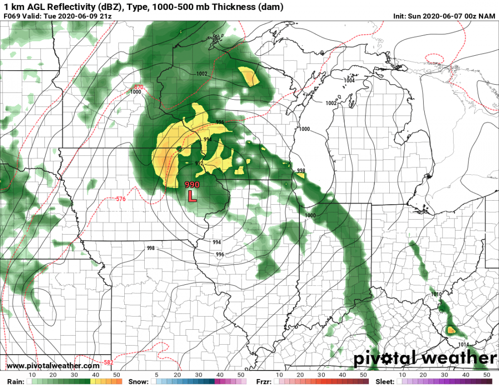
I mean look at this thing
Area Forecast Discussion
National Weather Service Chicago/Romeoville, IL
338 PM CDT Mon Jun 8 2020
.SHORT TERM...
317 PM CDT
Through Tuesday Night...
Plenty of unpack with the forecast through the next 48 hours. The
main forecast messages remain with some ability to provide more
specificity, although a couple aspects remain modestly uncertain
for this close in timing owing to subtle differences in system
track and evolution. The messages are:
- Tuesday mid-afternoon through mid-evening (~3-11 p.m.) likely
being the main window of impact for our area
- Strong winds with regular gusts of 35-45 mph, potential for
sporadic 50+ mph during this time, while Wednesday`s winds look
less impacting than they had
- Scattered severe storm threat, even some of the activity not
having much or any lightning
- Period of tropical-like rainfall rates overlapping the late day
commute
Today finds the area under a stout upper level ridge, with
suppression aloft likely being enhanced around the outer
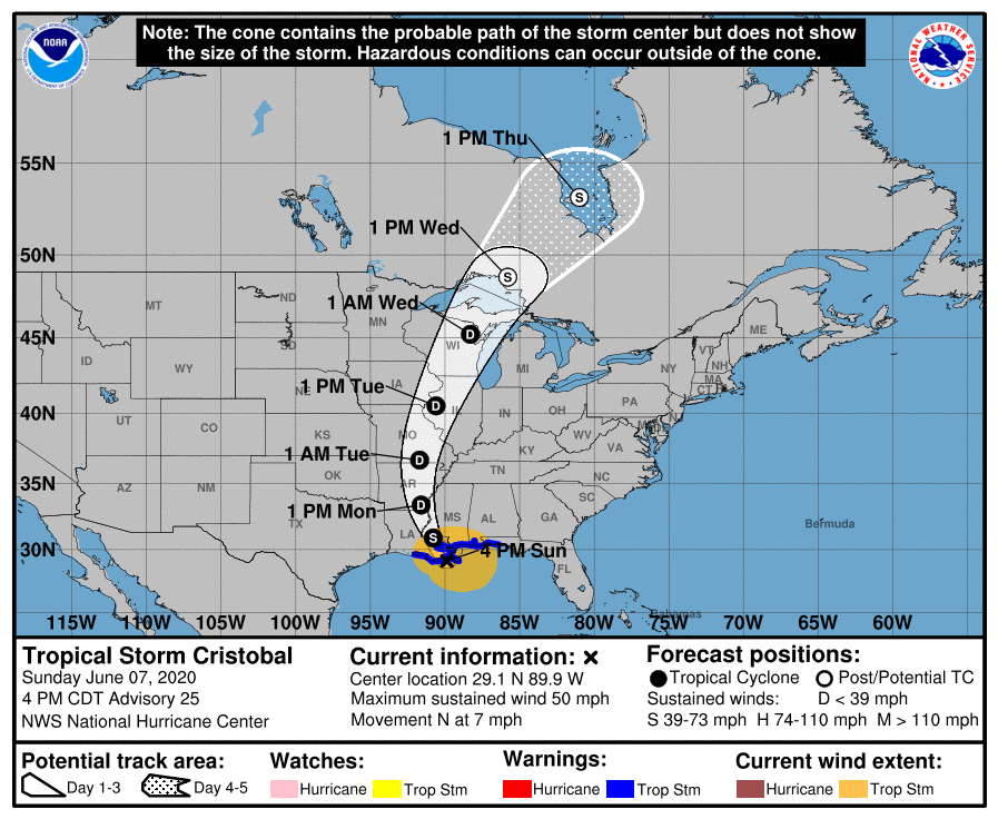
periphery of now Tropical Depression Cristobal which is near the
Arkansas/Mississippi border slowly moving north. Temperatures of
89 to 94 over dew points around 50 will be prevalent through 5
p.m. before gradual cooling. The outer spiraling cirrus edge of
Cristobal will spread northward over the area this evening and
then thicken overnight with lows of 65-70.
Guidance has gradually honed more in on the solution track of the
remnant mid-level to surface circulation of Cristobal, taking it
northward right over the Mississippi River. This is forecast by
the National Hurricane Center to be centered just north of the
Quad Cities by late day Tuesday. As a continued warm core system
it should be retaining primarily tropical-like characteristics,
though some mid-latitude / extratropical evolution may be starting
and likely will more rapidly Tuesday night as the system tracks
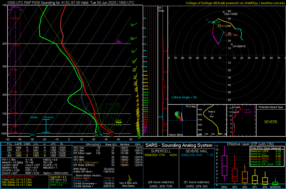
north of the area. The strongest 925 mb winds of near 50 kt over
the area are forecast to be mid-late afternoon through mid-
evening, and this is coincident with the near-record high absolute
moisture values (PWATS of 2.25 inches) and the developing
negative tilt of the mid-level circulation. A probable key to both
wind magnitude and severe potential is if any destabilization can
be achieved in that lowest km or two of the troposphere to result
in momentum transfer of stronger winds and for parcels in an
vorticity-rich low-level environment to achieve LFC heights.
.Tuesday Synoptic Winds...
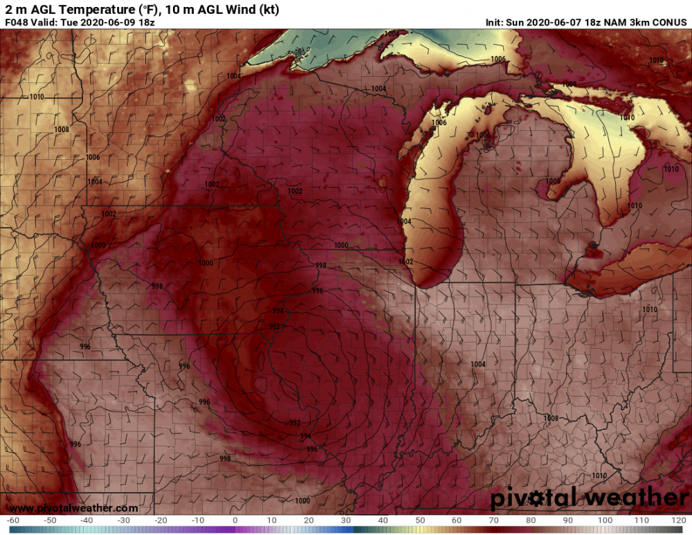
Confidence remains high on a period of strong southeast to south
winds Tuesday afternoon and Tuesday evening, but lower on the peak
wind gust magnitudes and how prevalent these will be. For this
reason, opted to hold off on any wind headlines and allow the
evening and midnight shifts to take another look at the latest
guidance trends.
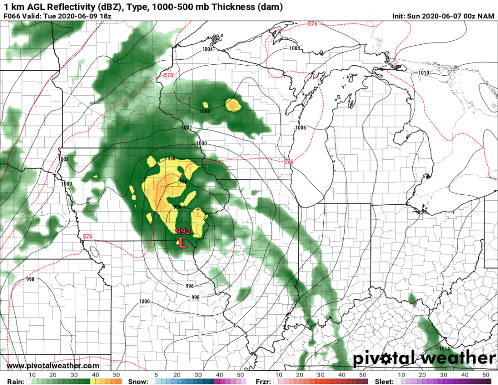
As the center of TD Cristobal lifts northward near the Mississippi
River on Tuesday afternoon, a corridor of stout pressure falls
will overspread the region as the system`s strong low level wind
fields arrive. Even at about 24 hours out, there are non trivial
differences in the model guidance with respect to the exact track
and strength of Cristobal. In addition, there is uncertainty on
mixing depths as the peak low level jet magnitude arrives Tuesday
afternoon into Tuesday evening. This is because the low level
wind core will be in tandem with the rain bands, which will lower
mixing depths. ECMWF and UKMET are most concerning from a wind
perspective, as they still deepen the low to sub 990 mb at our
latitude, with GFS not quite as deep, but forecast soundings still
suggesting 40+ kt speeds not too far above 1000 ft AGL could be
mixed down. NAM had weakest and farthest east solution of the 12z
cycle. It could be an outlier, but not confident enough to
completely discount that idea.
Think that we`re likely headed for needing a Wind Advisory for a
portion of the area, most likely the southeast 1/2 or 2/3 of the
CWA given NHC consensus low pressure track. With such strong winds
off the deck, even if diminishing mixing heights render 45+ mph
gusts somewhat less frequent, even aside from deeper convection,
showers may be able to tap into the stronger winds aloft. Given
the lingering uncertainty on exact timing, duration and areas
impacted, opted to hold off on a Wind Advisory issuance with this
forecast package in collaboration with neighboring offices. As
mentioned above, wind direction with strongest winds will start
out southeasterly and then shift to south and then south-southwest,
with speeds then gradually easing by midnight or so as direction
becomes more southwesterly. Will message gusts up to 40-45 mph,
with gusts of 50+ mph still possible, especially in heavier showers.
.Tuesday Severe Potential...
The pattern in the mid-level heights, low-level wind field,
surface winds, and just being in the right front quadrant of an
inland tropical system are concerning for rotating storms.
However, instability may be nearly nil if the rain shield is large
and steady enough during the afternoon into early evening. Any
arc-like structures or more scattered activity that develops will
be more susceptible to subtle heating and destabilizing to
support tapping into the strong wind field and providing some
depth to rotating updrafts for isolated severe wind and tornado
potential. The trend is slightly later in this timing, more later
afternoon into mid evening, which is when low-level instability
from central Illinois is likely to advect northward into at least
the southern forecast area and possibly all the way up to Chicago.
Lightning is likely to be limited especially with any activity
within the main rain area. In terms of convective wind potential,
given 50 kt flow at 2000 ft and very limited inversion, any
deeper storms would be able to maximize that and could produce
isolated damaging winds. For tornado potential, some if not
numerous rotating updrafts are likely late day into Tuesday
evening just south or into the CWA, again depending on if
activity can get into more of a mode or arcs/scattered to harness
some destabilization. The potential is there for tornadoes to be
of a short-lived nature given the shear highly outweighing the
instability, and just a rich moist environment too. It`s not
impossible some more true supercell structures could develop in
east central IL and graze into the far southeast forecast area
given trajectories of deeper instability, especially early Tuesday
evening (7-10 p.m.).
.Tuesday Heavy Rain Potential...
The longer duration heavier rainfall with Crisotbal`s remnants
observationally upstream and into Tuesday model solutions looks
to be near and just west of the center of circulation. This has
some buffer before overlapping north central Illinois, so that`s a
good sign. Given the absolute moisture values though, periodic
heavy rainfall rates within a 3-6 hour window sometime within mid-
afternoon through mid-evening are likely. This would overlap the
commute time and given tropical-like rain, this could sharply
reduce visibility and lead to localized flooding and temporary
hydroplaning concerns. But this threat does look much more
localized especially compared to a couple of the more widespread
May events. Total forecast rainfall through Tuesday night is
likely to exceed one inch in places, most favored along/north of
I-88. We are not expecting rises in rivers to be significant at
this time.
.Beach Hazards and Lakeshore Flooding...
For northeast Illinois, a period of stronger mainly onshore winds
(southeast direction) will be seen later Tuesday morning into the
evening. This will be enough to support dangerous swimming
conditions and could result in low end lakeshore flooding. This
does not look to be a significant lakeshore flooding event.
MTF/RC
&&
.LONG TERM...
328 PM CDT
Wednesday through Monday...
Forecast guidance has decent spread on Wednesday, not that much of
a surprise given phasing of a mid-latitude trough and incoming
tropical remnants. The trend today was for a slower true phase of
this and thus a longer break in the stronger winds, and the second
maximum being less in wind speed and duration.
The mid-latitude trough is forecast to move over the area during
midday into afternoon Wednesday, acquiring a slight negative tilt
as it does. There are variances in speed and degrees of drying and
suppression behind Cristobal`s remnants, but in general guidance
does show some break in shower/convective coverage later Tuesday
night through Wednesday morning. Scattered showers and possibly a
few storms would be favored to develop immediately ahead of the
trough`s center. The 12Z NAM even supported some severe threat in
northwest Indiana and especially just east of the area, but that
was somewhat of an outlier solution with its further west
indication of that occurring. Rainfall with Wednedsay`s activity
could be an additional half inch plus in some places, again
northern Illinois north of I-80 most favored.
For Wednesday winds, the tightest pressure gradient envelops the
area later Wednesday into Wednesday night in guidance, not ideal
for overlapping the diurnal maximum. Also the phased low center,
while near an impressive four standard deviations from normal for
June in this region (983 mb), is located by that time well north
of the Great Lakes. The cold advection and unidirectional wind
profile may support some gusts over 40 mph, and its still within
the window of possibilities that this period needs a short lived
Advisory if the phasing shifts a little earlier/south than
current solutions support.


