-
Posts
47,183 -
Joined
Content Type
Profiles
Blogs
Forums
American Weather
Media Demo
Store
Gallery
Everything posted by Hoosier
-

June 20th, 2021 Severe Weather Event
Hoosier replied to HillsdaleMIWeather's topic in Lakes/Ohio Valley
-
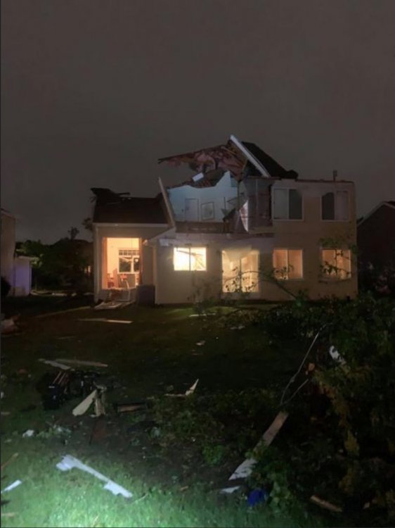
Significant tornado happened in the western suburbs (Naperville area)... likely EF2+ based on radar sigs and damage reports starting to come in.
-

June 20th, 2021 Severe Weather Event
Hoosier replied to HillsdaleMIWeather's topic in Lakes/Ohio Valley
It was undoubtedly a significant tornado in the western suburbs. Had the radar sigs and now the damage reports are trickling in to back it up. -

June 20th, 2021 Severe Weather Event
Hoosier replied to HillsdaleMIWeather's topic in Lakes/Ohio Valley
May have been something around Portage/South Haven, IN -

June 20th, 2021 Severe Weather Event
Hoosier replied to HillsdaleMIWeather's topic in Lakes/Ohio Valley
Time sensitive but Skilling is on the phone on WGN now. -

June 20th, 2021 Severe Weather Event
Hoosier replied to HillsdaleMIWeather's topic in Lakes/Ohio Valley
Chicago area TV stations are covering this. Injuries reported. -

June 20th, 2021 Severe Weather Event
Hoosier replied to HillsdaleMIWeather's topic in Lakes/Ohio Valley
Should get it good pretty soon. Can do without a tornado threat though... not a fan of these things coming in at night. -

June 20th, 2021 Severe Weather Event
Hoosier replied to HillsdaleMIWeather's topic in Lakes/Ohio Valley
Severe Weather Statement National Weather Service Chicago/Romeoville 1124 PM CDT Sun Jun 20 2021 ILC031-043-197-210445- /O.CON.KLOT.TO.W.0004.000000T0000Z-210621T0445Z/ Will IL-DuPage IL-Cook IL- 1124 PM CDT Sun Jun 20 2021 ...A TORNADO WARNING REMAINS IN EFFECT UNTIL 1145 PM CDT FOR NORTH CENTRAL WILL...SOUTHEASTERN DUPAGE AND SOUTH CENTRAL COOK COUNTIES... At 1123 PM CDT, a confirmed large and extremely dangerous tornado was located over Willow Springs, or over Justice, moving east at 50 mph. This storm has a history of producing damage across southern DuPage County, and radar has indicated debris lofted thousands of feet in the air. This is a PARTICULARLY DANGEROUS SITUATION. TAKE COVER NOW! HAZARD...Damaging tornado. SOURCE...Radar confirmed tornado. IMPACT...You are in a life-threatening situation. Flying debris may be deadly to those caught without shelter. Mobile homes will be destroyed. Considerable damage to homes, businesses, and vehicles is likely and complete destruction is possible. The tornado will be near... Oak Lawn, Midway Airport, Alsip, Midlothian and Crestwood around 1130 PM CDT. Chicago Lawn, Ashburn and Evergreen Park around 1135 PM CDT. PRECAUTIONARY/PREPAREDNESS ACTIONS... To repeat, a large, extremely dangerous and potentially deadly tornado is on the ground. To protect your life, TAKE COVER NOW! Move to a basement or an interior room on the lowest floor of a sturdy building. Avoid windows. If you are outdoors, in a mobile home, or in a vehicle, move to the closest substantial shelter and protect yourself from flying debris. && LAT...LON 4161 8805 4179 8798 4180 8769 4151 8778 TIME...MOT...LOC 0423Z 268DEG 44KT 4174 8787 TORNADO...OBSERVED TORNADO DAMAGE THREAT...CONSIDERABLE HAIL...<.75IN OEMC zones...TORNADO WARNING. 8 and 10. $$ FRIEDLEIN -

June 20th, 2021 Severe Weather Event
Hoosier replied to HillsdaleMIWeather's topic in Lakes/Ohio Valley
Reed Timmer is jelly. -

June 20th, 2021 Severe Weather Event
Hoosier replied to HillsdaleMIWeather's topic in Lakes/Ohio Valley
Needless to say we could have a real problem. It's basically a wall of suburbs and then eventually the city. -

June 20th, 2021 Severe Weather Event
Hoosier replied to HillsdaleMIWeather's topic in Lakes/Ohio Valley
-

June 20th, 2021 Severe Weather Event
Hoosier replied to HillsdaleMIWeather's topic in Lakes/Ohio Valley
Good reason the sirens are going off. -
Your boy has the lowest amount of rain in Indiana this month.
-
If the final 10 days of June just go average at ORD, the month would finish as the 4th warmest June on record. There are some below average days coming up, but this should be offset to an extent by some warmer than average days mixed in. A top 5 warmest finish looks to be achievable.
-

June 20th, 2021 Severe Weather Event
Hoosier replied to HillsdaleMIWeather's topic in Lakes/Ohio Valley
Generous to call the earlier stuff a round, don't you think? -
Gotta try a different method. After whatever falls tonight, it looks mostly dry until later in the week.
-
GFS has a tropical remnant in 15 days.
-

June 20th, 2021 Severe Weather Event
Hoosier replied to HillsdaleMIWeather's topic in Lakes/Ohio Valley
Area Forecast Discussion National Weather Service Chicago/Romeoville, IL 204 PM CDT Sun Jun 20 2021 .MESOSCALE DISCUSSION... 203 PM CDT The MCV we have been monitoring since daybreak is struggling to maintain a consistent footprint of deep convection as it enters west- central Illinois early this afternoon. Even with these radar trends, conditions continue to destabilize south of the warm front, which is now analyzed to be roughly from northern La Salle County eastward between I-80 and I-88 into extreme northwest Indiana. Deep-layer shear of 40kt+ remains present with 50-60kt of mid-level flow per KLOT VWP. The lack of increasing convection suggests low-level capping may be a little more robust that previously thought, likely owing to slower heating from the cirrus canopy filtering overhead since this morning. With this complex mesoscale set-up, CAMs unsurprisingly continue to struggle. However, the trend of hourly CAMs to quickly re-develop convection as the MCV enters the CWA is entirely plausible if the CAP is indeed taking longer to erode. We now have to focus on the prospect that the afternoon convection does not fully materialize and determine the implications as we move into this evening. With minimal convection this afternoon, the low- level air mass should quickly recover on a developing 50kt+ LLJ. So, round two of potential severe convection along the cold front mid to late evening is still in play, with pockets of damaging winds and perhaps embedded QLCS tornadoes near and south of the warm front. Kluber -
Euro advertising pretty low dews again for this time of year early in the week.
-
Half the country didn't even report yesterday. Seems like that is becoming more common on weekends.
-

June 20th, 2021 Severe Weather Event
Hoosier replied to HillsdaleMIWeather's topic in Lakes/Ohio Valley
Ha, well, don't base your decision off of my post. When I was looking at the CAM progs, I was thinking what does this appearance remind me of, and 6/30/14 was one that came to mind. There was uncertainty about what that second wave of convection would do as it moved east, and it ended up being a prolific QLCS tornado producer south of Chicago. -

June 20th, 2021 Severe Weather Event
Hoosier replied to HillsdaleMIWeather's topic in Lakes/Ohio Valley
Not predicting a repeat but I'm getting a slight 6/30/2014 vibe with the evolution today/tonight. -

June 20th, 2021 Severe Weather Event
Hoosier replied to HillsdaleMIWeather's topic in Lakes/Ohio Valley
Mesoscale Discussion 1032 NWS Storm Prediction Center Norman OK 1057 AM CDT Sun Jun 20 2021 Areas affected...far southeast IA...far northeast MO...much of central into northern IL...northwest IN Concerning...Severe potential...Watch likely Valid 201557Z - 201800Z Probability of Watch Issuance...80 percent SUMMARY...A watch will likely be needed for parts the mid MS Valley across IL and into northwest IN. Storms are expected to develop, intensify, and pose a severe risk as they move from near the IL/IA/MO border east-northeast across IL to the southern shore of Lake MI during the afternoon and early evening. Convective trends will be monitored through the late morning and into the midday hours for an eventual likely watch issuance. DISCUSSION...Radar mosaic late this morning shows a series of MCVs located from northeast IA, central IA, and northern MO moving east. Visible satellite shows a growing thunderstorm cluster across northern MO associated with the southern-most MCV. Surface analysis places an outflow boundary from northeast MO east into central IL. South of the boundary, southerly surface winds and temperatures in the lower 80s with dewpoints near 70 deg F are noted as of 10am observations. North of the boundary, cloud debris has tempered surface heating with temperatures ranging from the mid 70s from a Quincy to Peoria line and lower 70s over northern IL. Model guidance varies considerably regarding the details of potential convective evolution across central and northern IL this afternoon. As a result, there is relatively large uncertainty. However, timing of the MCV and its eastward translation would lead to the potential for storm development and a corresponding risk for severe as it progresses east across the middle MS Valley. Forecast sounding show moderate destabilization across central IL by early to mid afternoon (2000-2500 J/kg MLCAPE). Equally important, the low to mid-level flow fields strengthen and forecast hodographs enlarge during the mid to late afternoon. Consequently, it seems the risk for organized severe storms (including bows or supercells or mix thereof) and the associated severe hazards will increase coincident with this wind field response. Due to the large spread in possible solutions for this forecast, observational trends will disproportionately weigh in the decision of a potential severe-storm watch issuance. ..Smith/Hart.. 06/20/2021 -
I had read that people with certain blood cancers or organ transplant patients have a very reduced response to the vaccine... in some cases almost no response. People with RA, lupus, or other autoimmune conditions seem to have a somewhat reduced response to the vaccine, though everybody is different of course. I hadn't seen anything about the type of circumstance in my other post (going on an immunosuppressant well after vaccination) but it probably makes sense to take precautions just in case. The timeline of the person in my story is unfortunate... if you recall, we were seeing an upswing in cases back in April. Since cases have been dropping lately, perhaps they wouldn't have caught covid if we were talking about now.
-
I was at a party and there were some people there who I hadn't seen since before covid. Anyway, I was talking with someone and covid came up. She told me a story about her respiratory therapist friend. That person was vaccinated back in February and had to go on prednisone in April for a nerve issue. While on prednisone, the respiratory therapist caught covid. This was a couple months after being fully vaccinated. They are still having some lung/breathing issues. You'd think that there was enough separation between getting vaccinated and going on prednisone. The covid antibodies, etc would've already been established from the vaccine, but perhaps the immune function temporarily being held down by prednisone left that person more vulnerable. I wonder if there is any literature on something like this... going on an immune suppressant well after getting a covid vaccine. Anyway, perhaps a reason to be extra cautious while you are on a medication like that, even if you're fully vaccinated.


