-
Posts
47,183 -
Joined
Content Type
Profiles
Blogs
Forums
American Weather
Media Demo
Store
Gallery
Everything posted by Hoosier
-
I wouldn't have necessarily picked Missouri to be seeing the biggest rise right now, but here we are. Cases have risen about 75% there in a relatively short period of time, though we are still talking about numbers in the hundreds per day and not thousands.
-
Ollie Williams said it best Details/locations tbd but somebody could get slammed with a ton of rain.
-
Want some rain?
-
Minor point, but if anyone is actually interested in taking a crack at this, don't forget to account for the fact that average weekly rain over the next week is right around 1". So even though the current deficit is 7.17", you'd actually need slightly over 8" in the next week to overcome it entirely.
-
We should play a game. What will the yearly precip deficit be (or if anyone is bold enough, what will the surplus be) at ORD at the end of Tuesday, June 29? Current deficit for the year is -7.17"
-

June 20th, 2021 Severe Weather Event
Hoosier replied to HillsdaleMIWeather's topic in Lakes/Ohio Valley
LOT has a survey map up. Looks like the EF-3 and even EF-2 damage was very limited in scope along the path. It is fortunate that that type of damage didn't have a larger footprint, because it may have meant more injuries and possibly some fatalities. -

June 20th, 2021 Severe Weather Event
Hoosier replied to HillsdaleMIWeather's topic in Lakes/Ohio Valley
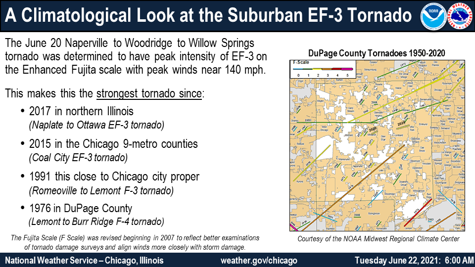
Some details on the EF-3 PRELIMINARY LOCAL STORM REPORT NATIONAL WEATHER SERVICE CHICAGO IL 347 PM CDT TUE JUN 22 2021 ..TIME... ...EVENT... ...CITY LOCATION... ...LAT.LON... ..DATE... ....MAG.... ..COUNTY LOCATION..ST.. ...SOURCE.... ..REMARKS.. 1105 PM TORNADO 2 SSW NAPERVILLE 41.74N 88.17W 06/20/2021 DUPAGE IL NWS STORM SURVEY *** 11 INJ *** AN NWS STORM SURVEY DETERMINED THAT AN EF-3 TORNADO WITH PEAK WINDS OF 140 MPH, PATH LENGTH OF 16.1 MILES, AND MAXIMUM WIDTH OF 600 YARDS IMPACTED NAPERVILLE, WOODRIDGE, DARIEN, BURR RIDGE, AND WILLOW SPRINGS DURING THE EVENING OF JUNE 20, 2021. AROUND 230 HOMES SUSTAINED DAMAGE IN NAPERVILLE AND WOODRIDGE, AND CONSIDERABLE TREE DAMAGE OCCURRED ALONG THE PATH OF THE TORNADO. THE MOST SIGNIFICANT DAMAGE WAS NOTED NEAR PRINCETON CIRCLE IN NAPERVILLE WHERE A HOUSE COMPLETELY COLLAPSED AND MULTIPLE NEARBY HOMES SUSTAINED CONSIDERABLE DAMAGE TO THEIR ROOF AND WALLS. ADDITIONAL SIGNIFICANT DAMAGE OCCURRED IN WOODRIDGE WHERE SEVERAL HOMES LOST THEIR ROOF AND WALLS. THE TORNADO WAS ON THE GROUND FOR APPROXIMATELY 20 MINUTES BEFORE LIFTING NEAR BUFFALO WOODS IN WILLOW SPRINGS, AND CROSSED INTERSTATES 355 AND 55 ALONG ITS PATH. -

June 20th, 2021 Severe Weather Event
Hoosier replied to HillsdaleMIWeather's topic in Lakes/Ohio Valley
There's a zone of enhanced damage around far eastern Gary and over the county line into Porter county. LOT has a survey team out there so will be curious as to the determination. Storm was actually fairly garden variety here... breezy but nothing extreme... so it seems like it waned as it came through before picking up again farther east. -
Euro has some enormous amounts in a stripe from east central IL to southern MI. Heavy amounts farther north too.
-
The nearly 1" of rain the other night seems to have done absolutely nothing for the grass... areas that were brown are as brown as before. This surprised me because I expected to see at least some greening.
-
There's at least the potential to really make some big progress on this in some areas in the coming days, instead of the more modest chipping away. But I go back go my slave to convection phrase. You have to see it play out in the right spots.
-
I've found that there are times that I like hiding behind the mask. People can't read your facial cues/expressions so well. I'm probably a little weird.
-
lol
-

June 20th, 2021 Severe Weather Event
Hoosier replied to HillsdaleMIWeather's topic in Lakes/Ohio Valley
-

June 20th, 2021 Severe Weather Event
Hoosier replied to HillsdaleMIWeather's topic in Lakes/Ohio Valley
Will be a lengthy clean up, and the landscape will show the effects for years. I can drive through the area of Griffith where the EF-2 hit in 2008 and still tell that something happened there. There's a zone without trees or newer trees that are smaller than others nearby. -
Getting close to having max vax protection. My intent had been to wear a mask indoors until fully vaxxed (as per CDC guidance) and then stop, but my thinking on this is evolving. I may still wear one indoors where there are a lot of people and at other times if I just want to hide my face. No, I'm not planning to rob a bank lol Let's face it, people are kinda gross (except, of course, my fine friends here at American Weather) so if a mask helps cut down on the potential of picking up non-covid illnesses, that's great. Although the amount of mask wearing is dropping, there are still more than enough people wearing them around here that you don't look like a weirdo for wearing one. I am young, not immunosuppressed and had systemic side effects from the vaccine, so there is every reason to feel confident that I am mounting a very robust immune response from it. For me, wearing a mask at times is not going to be about covid. Anybody else feel like this?
-
Tis the season for being a slave to convection. The more stratiform type of stuff can actually be quite beneficial as long as it's more than a piddly amount.
-

June 20th, 2021 Severe Weather Event
Hoosier replied to HillsdaleMIWeather's topic in Lakes/Ohio Valley
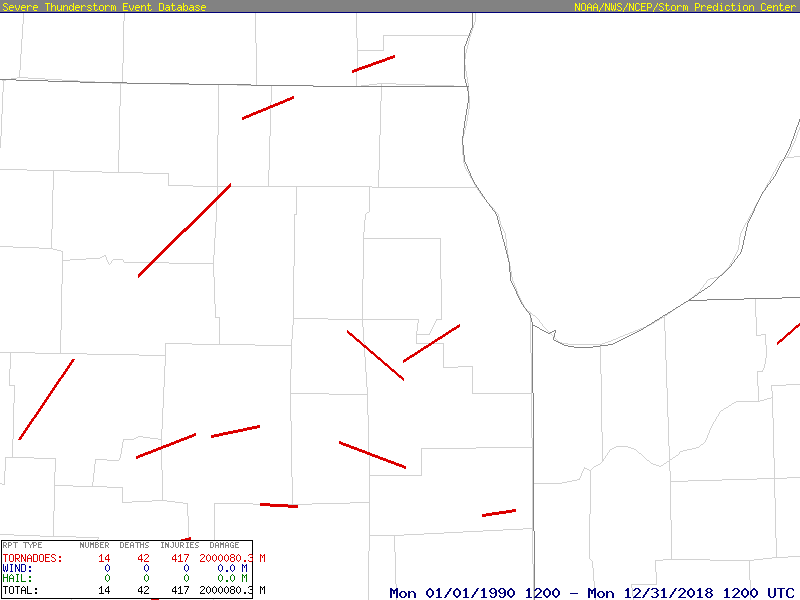
Here is a plot of F/EF3 or greater tornadoes in and surrounding the Chicago metro area since 1990 (map goes through 2018, but there was nothing in 2019-2020). The one going northeast from Will into Cook is the 3/27/1991 tornado that I mentioned earlier. For those familiar with the area, you can sort of mentally add in the Naperville area tornado. -

June 20th, 2021 Severe Weather Event
Hoosier replied to HillsdaleMIWeather's topic in Lakes/Ohio Valley
Naperville tornado is a preliminary EF-3 -

June 20th, 2021 Severe Weather Event
Hoosier replied to HillsdaleMIWeather's topic in Lakes/Ohio Valley
There is some subjectivity with what I'm saying, but in terms of something hitting more in the core of the Chicago metro area and not toward the fringes, this looks like the most significant hit in a while. If it does come in at EF3, then there isn't anything like it since the 3/27/1991 tornado that hit southwestern Cook county. I want to wait for more information though before evaluating its place in Chicago metro tornado history. Very fortunate that no fatalities have been reported. There's probably never a good time of day for something like this to go through a populated area... at night people are sleeping and more people are out and about during the day. It is a reminder of what can happen and that the area is vulnerable to significant tornado strikes... probably more vulnerable than it has appeared in recent decades which have been on the "quiet" side in that regard. This was a noteworthy event, but based on multiple past examples, we know we will see something worse one day. -

June 20th, 2021 Severe Weather Event
Hoosier replied to HillsdaleMIWeather's topic in Lakes/Ohio Valley
Some were injured enough to be taken to the hospital, but not sure what the criteria is for that. -
I know Indiana has stopped reporting on Sundays.
-
1.85" fell at ORD. That's good. What's not as good is that about 1.8" of it came in 50 minutes. You'd rather have it more drawn out than that. Ended up less than 1" here.
-

June 20th, 2021 Severe Weather Event
Hoosier replied to HillsdaleMIWeather's topic in Lakes/Ohio Valley
Dipping into scanner traffic and it sounds like there may be some serious injuries. Hopefully it's not the case.


