

Runman292
-
Posts
749 -
Joined
-
Last visited
Content Type
Profiles
Blogs
Forums
American Weather
Media Demo
Store
Gallery
Everything posted by Runman292
-
It's almost as if they saw the recent runs and were like "Yes, we have an excuse not to issue warnings!"
-
MRX AFD: Discussion: Bottom line up front: No change will be made to the Winter Storm Watch at this time, due to the lowered confidence in p-types and snow amounts. To issue a Warning beyond 24 hours, confidence must be high that Warning criteria will be met and that impacts will be significant. Model trends and differences: The NAM has thrown a wrench in the forecast with its depiction of a warm nose spreading well northward into our area, due to its strong southerly low level jet. This potential for mixed p-types adds much uncertainty to the forecast snow amounts in southern sections and in the lee of the mountains. The main difference in the NAM is that it develops a secondary surface low in northern AL on Friday afternoon, which tracks NE along the Cumberland Plateau to WV through the evening. This creates a strong pressure gradient across the TN mountains, and a 40-50 kt LLJ. However, it is noteworthy that this is not a typical mountain wave/downslope enhancement pattern, which is usually characterized by a 850 mb jet max to our NW, so perhaps the NAM is overdone with the downslope warming. Also, the NAM is an outlier in its solution, as the GFS and ECMWF do not develop this secondary low and LLJ, and keep warm advection to our south. The HRRR seems to be a compromise solution, and is not as aggressive with the warm nose and LLJ as the NAM. Precipitation types: At onset Friday morning, temperatures profiles will support all snow as top-down moistening evaporatively cools a dry low level layer. HREF p-type probs show a snow/sleet/fzra mix entering southern sections between 1 PM and 4 PM EST. The northward extent of this mix is a big uncertainty, but for this forecast, the HREF probs look reasonable, and keep the mix mainly to the south of I-40. The strength of the downslope wind will affect the p-type in the foothills north of I-40 and the Tri-Cities, and the potential for a brief period of mixed p-types may result in lowered snow amounts there. Snow amounts and confidence: The area of highest confidence in the snow amount forecast is north of I-40 and west of I-81, in the northern Cumberland Plateau area and KY border counties, where the p-type is highly likely to remain all snow. In this area, amounts are expected to be in the 4-6" range. As we go south and east from there, confidence lowers due to the above mention p-type issues. In the southern Valley and SW NC, 1- 3 inches of snow is expected, mainly during Friday morning and early afternoon before the mix takes over, with the potential for up to a tenth of an inch of ice accumulation in the mid/late afternoon and evening. Another factor in the snow amounts will be the loss of moisture in the dendritic growth zone from the dry slot Friday evening, which may shut off accumulating snowfall sooner than previously forecast. The chance of accumulating precip drops rapidly between 7 PM and midnight EST as the dry slot moves overhead. Freezing drizzle may be a concern during this period. Timing: Not much has changed from previous forecasts regarding the timing of snow onset Friday morning. Expect that the morning commute in the Chattanooga area could be impacted by snow, potentially starting as early as 7 AM EST but accumulating mainly in the 9-11 AM time frame as snowfall rates increase. In Knoxville, 10 AM to noon appears to be the likely time frame for snow to start accumulating, with Tri- Cities being in the noon to 2 PM window. Peak precip intensity appears to be during the afternoon, from around 1 PM EST to 7 PM EST. Precip will begin to end near or after 7 PM from SW to NE as the dry slot moves across the area and brings drying in the dendrite growth zone. This end time is faster than previously forecast, but the end time of the Winter Storm Watch will be kept at 7 AM EST Saturday. We transition to a NW flow pattern Friday night, which may result in some additional light snow accumulation in SW VA and the TN mountains into Saturday morning.
-
MRX is holding off on the warning upgrade. Leaning heavily towards the NAM while acknowledging that it's an outlier.
-
To be honest, WVLT has gone down the drain since Aldrich left.
-
MRX be like: "Is that the smell of lowered snow totals? Looks like NAM is back on the menu, boys!"
-
That is basically me as well. I don't sleep when a winter storm is close.
-
I know. Morristown Mets usually aren't that aggressive when talking about snow amounts, lol.
-
MRX's AFD is mentioning a potential for even higher snow amounts than the watch indicates.
-
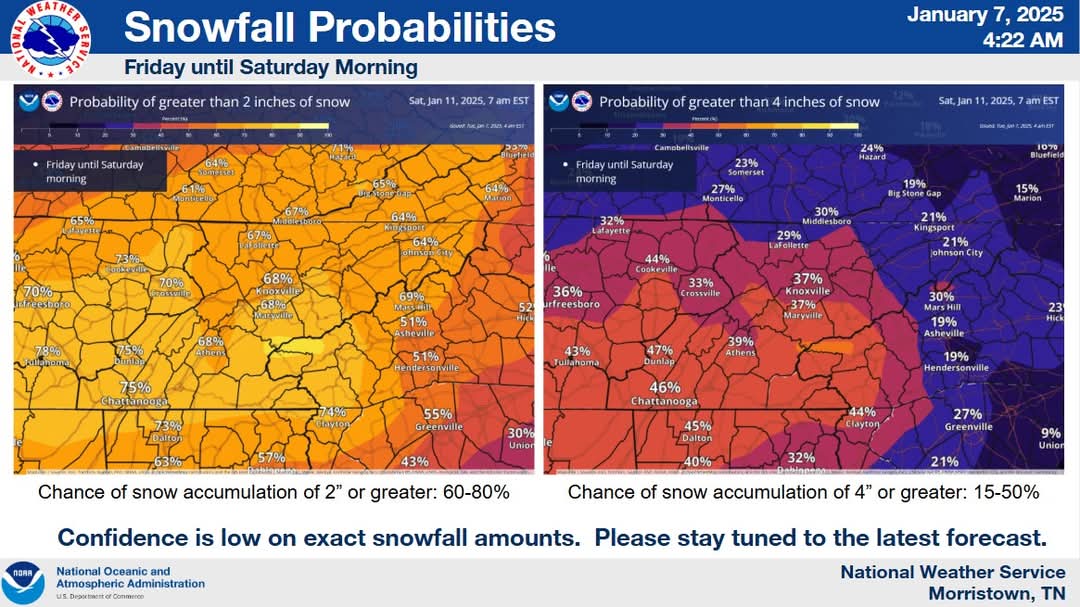
MRX has made it official. The entire state is under a Winter Storm Watch. 3-7 inches mentioned in their watch.
-
Was it that Ben guy?
-
Sleet is better than freezing rain.
-
Just woke up so I probably missed the event. No precip in Oak Ridge. My back road that is never treated isn't slick, so any ice that formed has melted.
-
Anyone in the Nashville area seeing a mix right now?
-
Areas along Interstate 40 and 81 have now been included into the Winter Weather Advisory.
-
RGEM puts a bullseye right on Anderson County. I definitely don't want to see three tenths of an inch of ice.
-
Now that we have advisories in the northern parts of TN, it's as good of a time as any for this thread. MRX: .LONG TERM... (Sunday through Friday) Issued at 340 AM EST Sat Jan 4 2025 Key Messages: 1. A winter storm will affect portions of the area Sunday into Monday. Ice accumulation is expected, mainly north of I-40 and west of I-81. 2. Potential for high winds for the mountains and foothills Sunday night into Monday. 3. Very cold air remains across the region next week. Discussion: Overall, not much has changed regarding the upcoming winter storm that will affect the area on Sunday into Monday. Winter impacts are expected across portions of our forecast area, especially in areas north of I-40 and west of I-81. Icing events are fairly uncommon in our area, unless there is a very cold air mass already in place before precipitation arrives. It appears we will have that setup for this winter event. Strengthening isentropic ascent will produce light precipitation beginning Sunday morning, mainly west of Interstate 75, with precipitation gradually beginning to increase eastward throughout the day. At the onset of precip, very cold, dry air will be in place at the surface. Initially, precip will have a difficult time making it to the surface, and this evaporative cooling will help maintain sub-freezing surface temperatures into the afternoon as precip rates intensify. Temperatures will likely be slow to rise despite warm advection aloft, creating a setup for freezing rain. Models often tend to erode the shallow cold air too quickly in these situations. QPF totals are light Sunday, but even light amounts around 0.1 inch would result in hazardous, icy travel. With the southerly flow, downslope and warming conditions across the western mountain foothills will result in a warm nose west of the mountain chain across the foothills. This means that the highest probabilities of freezing rain ice accumulation greater than 0.1 inch will be north of Interstate 40 and northwest of Interstate 81. The highest ice accumulation is still expected near the Kentucky line and into southwest Virgina, where 0.1 to 0.25 inch of ice accumulation is expected.Temperatures will gradually rise above freezing as warm advection takes over Sunday evening as the surface low move northeast across the Ohio River Valley. By Monday morning, winds shift to the WNW/NW as cold advection begins in the wake of a cold front. Scattered light snow showers are likely on Monday, especially across the higher elevations, as orographic lift enhances snowfall across the mountains. Based on the above, a Winter Weather Advisory will be issued for portions of the Cumberland Plateau and adjacent counties, where confidence is moderate that some ice accumulation will occur, beginning Sunday morning. In the SW VA counties, there will be more of a snow/freezing rain mix that complicates things, and lowers confidence that Warning criteria for ice (1/4 inch) will be met. The 06Z run of the HRRR is showing less ice and more snow for SW VA. With this lower confidence, and the timing of precip onset being mainly Sunday afternoon, the Winter Storm Watch will be maintained there. There is a potential for significant travel impacts on Sunday on I-75 and I-81 in SW VA.
-
Is it a proper time to start up a thread for Sunday?
-
Summer-Fall 2024 Weather Disco Med/Long Range
Runman292 replied to John1122's topic in Tennessee Valley
Apparently, even though we could see Helene as a tropical storm when it moves into TN, the NWS can't issue Tropical products for Tennessee according to MRX.- 689 replies
-
- 1
-

-
- heat
- thunderstorms
- (and 7 more)
-
Tornado Warning for Claiborne and Hancock counties.
-
I wonder how bad the squall line will be overnight with all of these storms moving through right now.
-
In addition, the 10% hatched tornado risk has expanded as far east as Knox County.
-
The rotation stayed just to the south of my house.
-
With the initial storms missing the eastern valley and staying in the northern plateau and Kentucky, will that lead to increased chances for worse storms later in the valley?


.gif.f872b58d96633aed8e46e26a59283155.gif)