Runman292
-
Posts
749 -
Joined
-
Last visited
Content Type
Profiles
Blogs
Forums
American Weather
Media Demo
Store
Gallery
Everything posted by Runman292
-
Do you think that morning rain and storms will lessen the risk in the central valley?
-
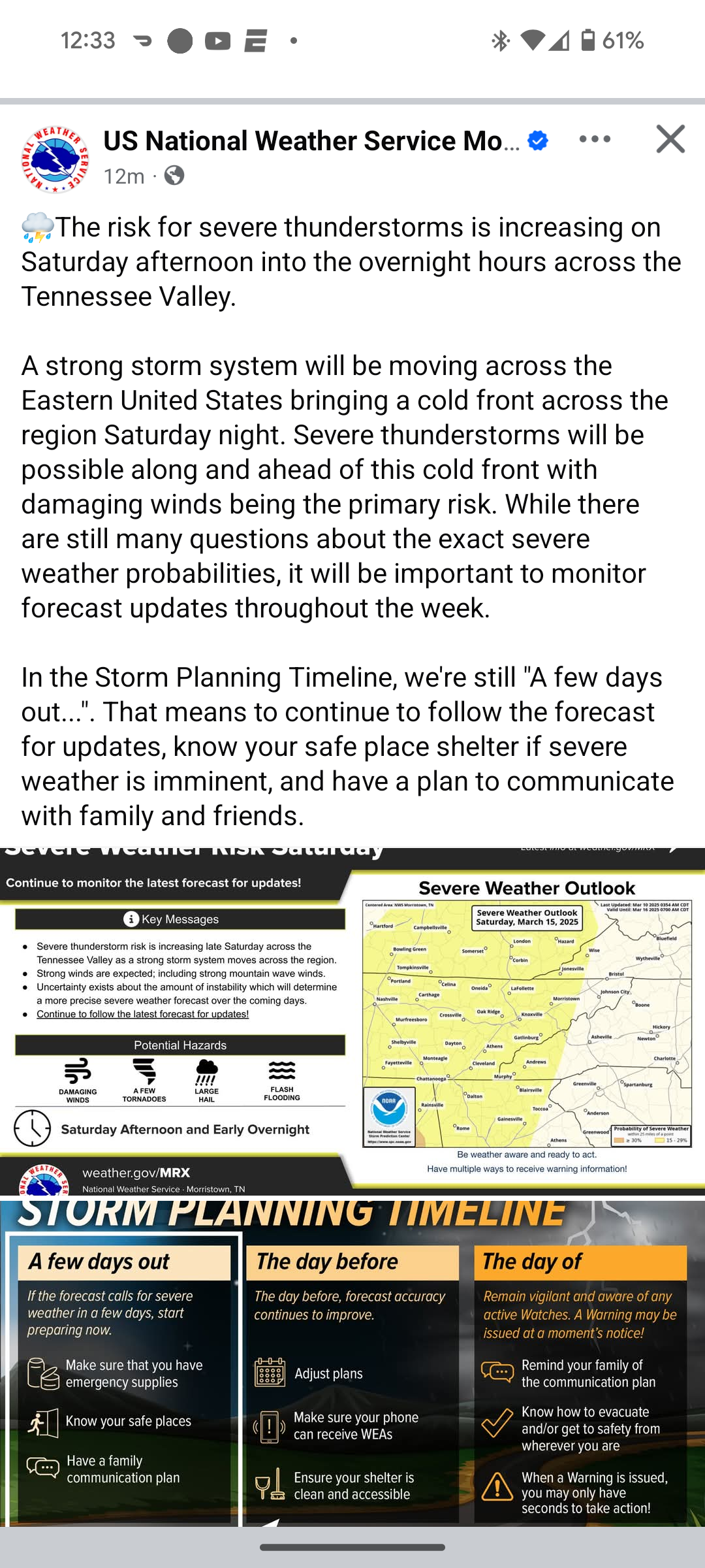
Here's the AFD from MRX: 2. Severe Weather The original surface low is expected to track into Canada with another area of low pressure developing west of the Mississippi River Valley. During this time, focus will also turn towards impressive upper divergence due to a coupled jet structure Saturday afternoon. At the time of this update, the latest HREF data ends Friday evening with the FV3 and high-res NAM only reaching until 12Z Saturday. There are indications of decaying convection moving into the area Saturday morning but likely with only elevated instability. The main focus will be anytime from Saturday afternoon through Saturday night. The timing and some details will still need to be resolved with higher resolution model data, but the latest indications raise significant concerns for what will unfold. Very curved hodographs and MLCAPE over 500 J/kg are indicated during the day on Saturday with effective shear of well above 50 kts and low-level SRH of 300 to 500 m2/s2. The latest models indicate convection to be in the area Saturday afternoon, which would likely be in the form of robust supercells. This is noted even more notably to our south and west with this convection likely forming into a line and moving towards the area by the evening hours. With the environment being indicated from the NAM and other models, a severe weather outbreak with all hazards is likely in store across the region. There are still questions as to how the local environment will evolve in our area, in addition to the initiation, evolution, and coverage of convection. These details will be better resolved once more high-res model guidance is available through the event. Ahead of this potential line, most sources increase 850mb winds to in excess of 70 kts, which would present a significant damaging wind risk if these winds are brought to the surface.
-
I know it's way too far to determine this with any sense of absolute certainty, but if the instability is sufficient, could we see something similar to April 27th?
-
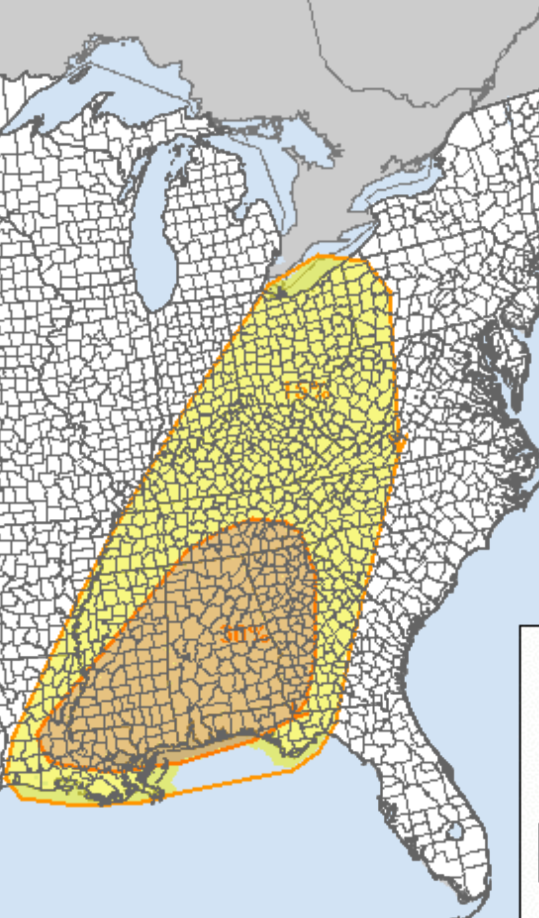
Day 4 Outlook from the SPC: ...SEVERE WEATHER OUTBREAK POSSIBLE ON D4/SAT... ...DISCUSSION... ...Day 4/Sat - Central Gulf Coast States to the Ohio Valley... A strong large-scale upper trough is forecast to quickly move across the Plains to the MS Valley on Saturday. An intense jet streak will move across the Deep South into the OH Valley as this occurs. At the surface, a low secondary to the 980 mb low over the Upper Midwest is forecast to develop during the late morning/early afternoon across the mid-South. This will aid in further northward transport of rich Gulf moisture into portions of the Lower MS Valley and TN Valleys. Atop this moisture-primed boundary layer, cold 500 mb temperatures are forecast. This may support fairly steep lapse rates, which would foster moderate instability across portions of MS/AL amid supercell wind profiles. However, some uncertainty remains tied to the evolution of convection in the Day 3/Fri period into the morning hours of Saturday. Some forecast guidance suggests a relatively pristine warm sector will be maintained, or if only isolated convection develops overnight/early Saturday, recovery could occur. If this scenario unfolds, a concerning severe weather setup supporting all-hazard severe could unfold across portions of LA/MS/AL through the day and into evening, and eventually spreading east into GA overnight. Trends will be monitored closely over the coming days and further adjustments to the 30 percent/Enhanced risk area may be needed in future outlooks. With northward extent, instability will become more limited. Nevertheless, sufficient moisture amid intense deep-layer flow will support swaths of strong/damaging winds into the Ohio Valley and portions of the central Appalachians Saturday and Saturday night. Higher outlook probabilities may be needed in subsequent outlooks if confidence increases.

-
As someone who is a novice to severe weather models, which ones do I need to look at?
-
Excerpt from the MRX AFD in regards to severe weather on Saturday. Severe Weather: The SPC has already included most of the region within a 15% risk area for severe thunderstorms on Saturday afternoon through the overnight hours with a 30% risk area delineated to our south and west. There are several factors influencing the severe weather risk.We will be warm sectored across the region, but the surface low will be far to our north into Ontario. As a vort maxima rotates through the upper-level trough axis, a secondary surface low feature is expected to develop across the Mid-South and move northeast into the Central or Southern Appalachians. This will enhance low-level and effective bulk shear in the vicinity of this surface low feature, and this is visualized in model sounding data showing long hodographs with strong curvature near the surface low feature. The wind fields are expected to be very strong across the region, but the limiting factor to higher severe weather probabilities at this time is questions about instability. Depending on the exact upper-level trough amplification and track of the secondary surface low, instability could vary significantly. If the surface low takes a slightly westward track, we will be in a favorable thermodynamic for supercell convection on Saturday afternoon that grows into a QLCS with wind damage and tornado potential Saturday night. If this surface low features tracks more eastward, we will likely see more of a flash flooding risk with the primary severe hazards remaining to our south and east. NWP guidance (GFS,ECMWF, ensembles) continue to indicate near 1000 J/Kg of MLCAPE and EBShear above 50 kt which would support an all-hazards severe weather event. ECMWF EFI is also near 0.9 with a SOT of 1 across the region which presents at least a weak to moderate signal for significant CAPE/Shear combination. Wind damage would be the primary risk, but tornadoes, flash flooding, and large hail would also be risks to monitor - especially with any supercells. This severe weather forecast will be important to monitor over the next several days.
-
Interesting to see local TV mets in East TN talk about severe potential 1 week in advance. That is definitely something they don't usually do.
-
Fall/Winter Banter - Football, Basketball, Snowball?
Runman292 replied to John1122's topic in Tennessee Valley
After February 14th, David Aldrich will no longer be doing Captain Accurate Weather in East Tennessee. He's going to Southeast VA to be the meteorologist for WTKR. -
I'm at the Dollar general in the West side of Oak Ridge and I can confirm. A good dusting on the grass
- 207 replies
-
- 3
-

-
- obs
- light snow
- (and 2 more)
-
A moving truck tried to go up my hill and got stuck on the hill. It took him 30 minutes of going backwards and forwards to realize that he wasn't going to get up the hill. He finally backed down the hill and went back into the turnpike.
-
The freezing rain has turned back into snow in Oak Ridge.
-
I thought I would see snow when I went out, but it's the dreaded freezing rain right now. I'm hoping it will turn back to snow soon. I thought we would have been north enough to see all snow.
-
It has changed from snow to freezing rain in Oak Ridge. The roads are snow and ice covered.
-
I have just a touch under 2 in my location in Oak Ridge.
-
Definitely coming down good in Oak Ridge.
-
I pray that everything will go well. I'm hoping that you get to enjoy the snow.
-
I'm in Oak Ridge, so I should be in the same boat. I'm rooting for the mix to stay more south into GA.
-
Looks like MRX is going all in on the western half of the Central valley, northern plateau, and Southwest Virginia getting hammered with snow.
-
Ladies and Gentlemen, MRX has finally joined the chat: All watches have been upgraded to warnings.
-
It's pretty cool to stay up all night and talk weather with everyone. I really enjoy learning a lot with these conversations.
-
WVLT Mets:

-
Could you post a map?
-
If you just read the bottom line, you would think that the storm is more of an inconvenience than a hazardous event.
-
Maybe I've missed it, but it seems like MRX never mentions models like the ICON. Why is that?