eyewall
-
Posts
13,328 -
Joined
-
Last visited
Content Type
Profiles
Blogs
Forums
American Weather
Media Demo
Store
Gallery
Everything posted by eyewall
-
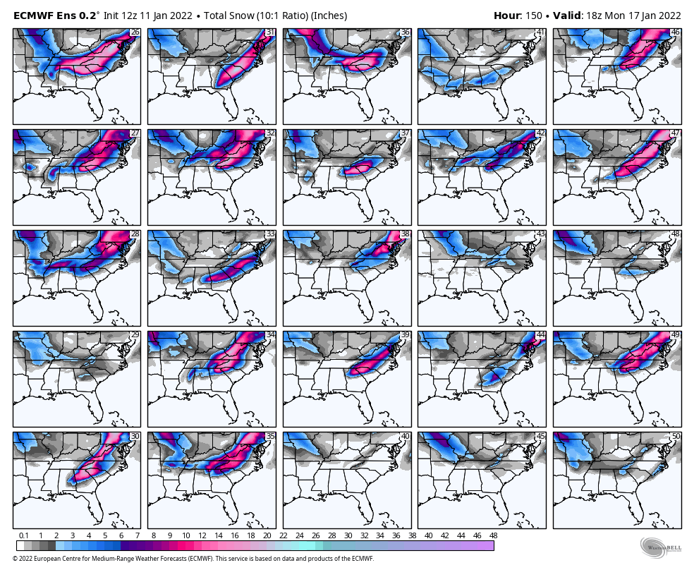
Nope, not going to get it where we need it on this run:
-
I have no idea. Would have to find maps from that time. I think it was in 94 but can't be 100% sure. As for the Burlington event that was in 2013 I believe. It was 55F at 4,000ft.
-
Yeah I saw it in the 90's on Long Island once. The best was witnessing 12F and freezing rain in Burlington VT.
-
Lake Tahoe
-
The screw line is somewhere in the vicinity of I-77 for now. The sad thing about losing this one is the ground was getting good and primed to maintain a snow cover.
-
We may have to start talking about tors in the Coastal Plain if this keeps up
-
If you are in our area there is every reason to be upset. Nobody likes a front ender to rain scenario with mainly a mix at the start to boot.
-
Current status: Boone: We're still good but have the munchies Charlotte: So you're saying there's a chance, yes! Winston-Salem: Checking the fuel supply in the generator Greensboro: Will it be cold enough to keep the beer cold outside? Raleigh-Durham: Tanking Old Tuffy Fayetteville: When does the ABC store open? Wilmington: Sleeping it off
-
Doom and gloom is justified for us in the RDU screw zone on this one.
-
Looking at the continued trends this morning I am inclined to say it won't work out for Central NC and the RDU region. That is unless you like a mix to rain scenario. I am almost ready to write this one off given the trends.
-
It stops at 90 hours so don't really get much out of it.
-
Yeah this is looking more and more like an I-77 special I hate to say.
-
As of now I am inclined to suggest this will be more of a mix event than a snow event in central NC, especially with it moving toward the Miller B side of things.
-
-
Current status: Boone: We're good Charlotte: This could be the one! Winston-Salem: Feeling good Greensboro: Feeling pretty good Raleigh-Durham: Tanking Maalox and downing Tums Fayetteville: Day drinking Wilmington: Hitting the ABC store to re-stock
-
Yeah that looks about right.
-
For anyone east of the Triad, see you in the Sanitarium. This obviously isn't looking good for us right now. The screw line on the Euro is just west of US-1.
-
This is make or break for the winter so hopefully everyone can get a little something.
-
I am reserving a spot here now after those 12z runs.
-
For the Triangle eastward you are saying "well that was fun while it lasted". This is not a good run at all for us. It would be snow to mix to rain followed by frozen puddles after. Even the Triad sees a sleet fest in this scenario. This would be an I-77 and west scenario in reality.
-
Yeah nobody wants to say it, but we could still lose this to VA. Once the trend north is established it usually doesn't come back.
-
Got to wait for February on that one.
-
In case anyone is worrying about soil temps, they are now in the 30's and 40's.
-
Agreed, the inland scenario is bad news to be honest. It would be a snow chase to the Triad