eyewall
-
Posts
12,466 -
Joined
-
Last visited
Content Type
Profiles
Blogs
Forums
American Weather
Media Demo
Store
Gallery
Everything posted by eyewall
-
The hard truth from RAH: A few showers may develop across the western Piedmont Saturday evening, then widespread precipitation will spread across the region Saturday night through early Sunday night. Models are coming into better agreement with the details, and confidence is increasing that this will be less of a snow event and more of a freezing rain/rain event. All areas will be below zero when precipitation begins to fall Saturday night, and most areas north of the Sandhills and southern Piedmont will likely see snow where it develops, while southern areas have a rain/snow mix. Then by early Sunday morning, a warm nose develops as the the possibility of freezing rain/sleet spreads north to just south of the Triangle by noon. By late Sunday afternoon, areas away from the Triad will likely have rain, while freezing rain becomes the dominant precipitation type across the northwest. This warm nose will lower snowfall amounts across most areas, even the Triad. Accumulating ice will become the greater hazard in the afternoon, and with wind gusts around 25 mph, could easily break weak icy tree branches. A dry slot will likely cut off moisture and end precipitation quickly late Sunday evening into early Sunday night. A Winter Storm Watch may be issued for portions of central NC either tonight or Friday morning. Highs Sunday will range from near 30 far NW to near 50 far SE.
-
Thanks for the trolling effort there. We are well aware.
-
Probably a fairly even split between Ice and Rain.
-
For Raleigh that will be Brief snow/sleet-->Ice-->Rain-->Dryslot-->Missed by the wrap around deform band to the NW
-
Which will all be wiped clean when we go to 40 and rain. I am not sure we will see 3-5 inches either before the mix.
-
Yep its looking like a done deal for Raleigh. Maybe next year we can reel in a 6+ event.
-
Yeah the writing is on the wall. It isn't our storm. Maybe next year.
-
Awful run for us in Raleigh. Any wintry precip definitely goes to rain in that scenario. I think the fat lady is warming up.
-
After that disaster strikes and it tracks right to Raleigh:
-
Coastal takes hold somewhere just inland in SC:
-
-
The GEFS won't save Raleigh on this run but here are the members:
-
Ahahah yeah for sure. Wish we could push the big totals farther east but I will settle for glazed tree shots I guess LOL. (I am in the bargaining phase of the grief cycle here).
-
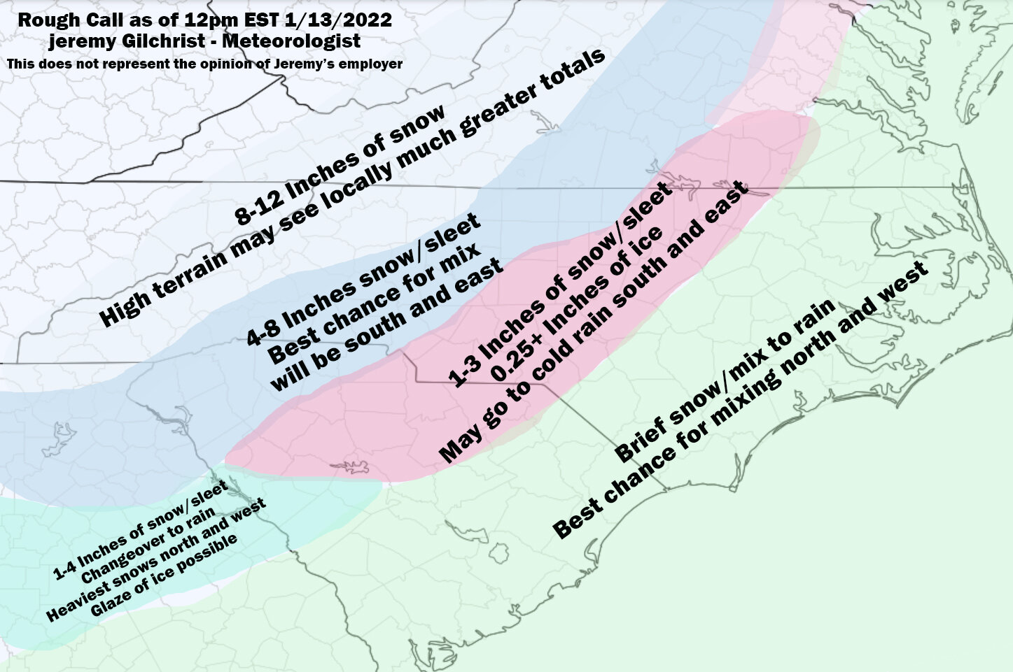
A rough go at a call map for now:
-
For RDU the dry slot cuts off the ice after a solid hit but the backside deform band misses to the NW. Another few ticks east and we could get into that.
-
It is a little better this run. Puts the ice corridor right up US-1:
-
The coastal crosses over the Sounds rather than up 95. This would mean a front end thump to mix, perhaps a dry slot and maybe catching a little on the back end:
-
It is the ICON but it transfers to a coastal low in the deep south with the new primary taking hold off Savannah/Charleston. The old low weakens south of Columbus, GA
-
NAM puts the baroclinic zone right where you want it and where it makes the most sense normally:
-
I am also a photographer so cold rain doesn't exactly make for great weather shots lol. ZR can if there is a enough on the trees though.
-
That is the problem is we go over to 38F and rain ultimately. Also the warm nose almost always overperforms compared to the models so it will mostly be sleet/ZR then rain.
-
It definitely is looking more and more like it will be shite for the RDU area. I think it is time to check out of this one. Enjoy to those that get it.
-
I think my last post was deleted but the 18z GFS was a glimmer of hope. It will take a lot to pull this from the grave at RDU but we shall see. I hate seeing the Euro stop at 90 hours for 18z.