eyewall
-
Posts
12,466 -
Joined
-
Last visited
Content Type
Profiles
Blogs
Forums
American Weather
Media Demo
Store
Gallery
Everything posted by eyewall
-
January 20-22 “bring the mojo” winter storm threat
eyewall replied to lilj4425's topic in Southeastern States
I think for central NC freezing drizzle will be a problem overnight and black ice. Radar returns look paltry. -
I would call it snizzle here for now.
-
January 20-22 “bring the mojo” winter storm threat
eyewall replied to lilj4425's topic in Southeastern States
I agree, the steady shield is almost through already. -
I haven't seen that but also I was not looking either so I will keep an eye out.
-
January 20-22 “bring the mojo” winter storm threat
eyewall replied to lilj4425's topic in Southeastern States
Yeah it will be interesting to see how much frozen sneaks in tonight before the main round. -
January 20-22 “bring the mojo” winter storm threat
eyewall replied to lilj4425's topic in Southeastern States
3+ is warning criteria for Raleigh. I'll take it. -
January 20-22 “bring the mojo” winter storm threat
eyewall replied to lilj4425's topic in Southeastern States
It was only a 1/2 inch on average lower than the 12z run. The overall coverage area was fairly consistent. It essentially held serve for this region. It increased a bit just NE. -
January 20-22 “bring the mojo” winter storm threat
eyewall replied to lilj4425's topic in Southeastern States
-
January 20-22 “bring the mojo” winter storm threat
eyewall replied to lilj4425's topic in Southeastern States
They haven't been to the school of NC weather with cold chasing the moisture. -
January 20-22 “bring the mojo” winter storm threat
eyewall replied to lilj4425's topic in Southeastern States
Paywalled. Can you give the general idea? -
January 20-22 “bring the mojo” winter storm threat
eyewall replied to lilj4425's topic in Southeastern States
Euro is not as good with phasing the vortmaxes compared to the 12z GFS run but it is close. Again that is the real key to this whole thing. -
January 20-22 “bring the mojo” winter storm threat
eyewall replied to lilj4425's topic in Southeastern States
Still in good shape there. -
January 20-22 “bring the mojo” winter storm threat
eyewall replied to lilj4425's topic in Southeastern States
yep much better interaction of our vortmaxes -
January 20-22 “bring the mojo” winter storm threat
eyewall replied to lilj4425's topic in Southeastern States
It is banking on two rounds with this area on the southern edge of the first and back in the main round as well. -
January 20-22 “bring the mojo” winter storm threat
eyewall replied to lilj4425's topic in Southeastern States
Here is to hoping as we anxiously await the 12z suite. -
The moose says you're closed. I say you're open!
-
Raleigh salvaging a good winter is on life support at this point that is for sure. It has been tough to be constantly shafted in a solid pattern.
-
January 20-22 “bring the mojo” winter storm threat
eyewall replied to lilj4425's topic in Southeastern States
-
January 20-22 “bring the mojo” winter storm threat
eyewall replied to lilj4425's topic in Southeastern States
Note the small differences in the vort max over TN along with the southern piece of energy. These subtle differences are going to make or break this event IMO. -
January 20-22 “bring the mojo” winter storm threat
eyewall replied to lilj4425's topic in Southeastern States
Interestingly, the GFS brings the main round of snow late Friday night/early Sat morning on the 6z run. Honestly I still don't think there is a good handle on all these little shortwaves and how they will interact with the front. I don't think any forecast an be one of high confidence and bust potential is high everywhere in either direction. -
January 20-22 “bring the mojo” winter storm threat
eyewall replied to lilj4425's topic in Southeastern States
6z GFS: -
January 20-22 “bring the mojo” winter storm threat
eyewall replied to lilj4425's topic in Southeastern States
Right now this is a distinct possibility yes. -
January 20-22 “bring the mojo” winter storm threat
eyewall replied to lilj4425's topic in Southeastern States
That is my real name -
January 20-22 “bring the mojo” winter storm threat
eyewall replied to lilj4425's topic in Southeastern States
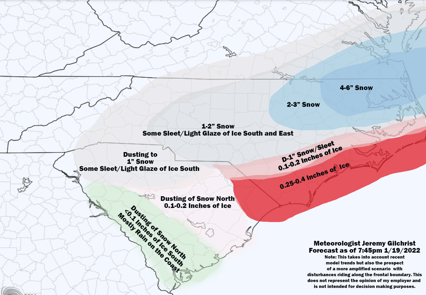
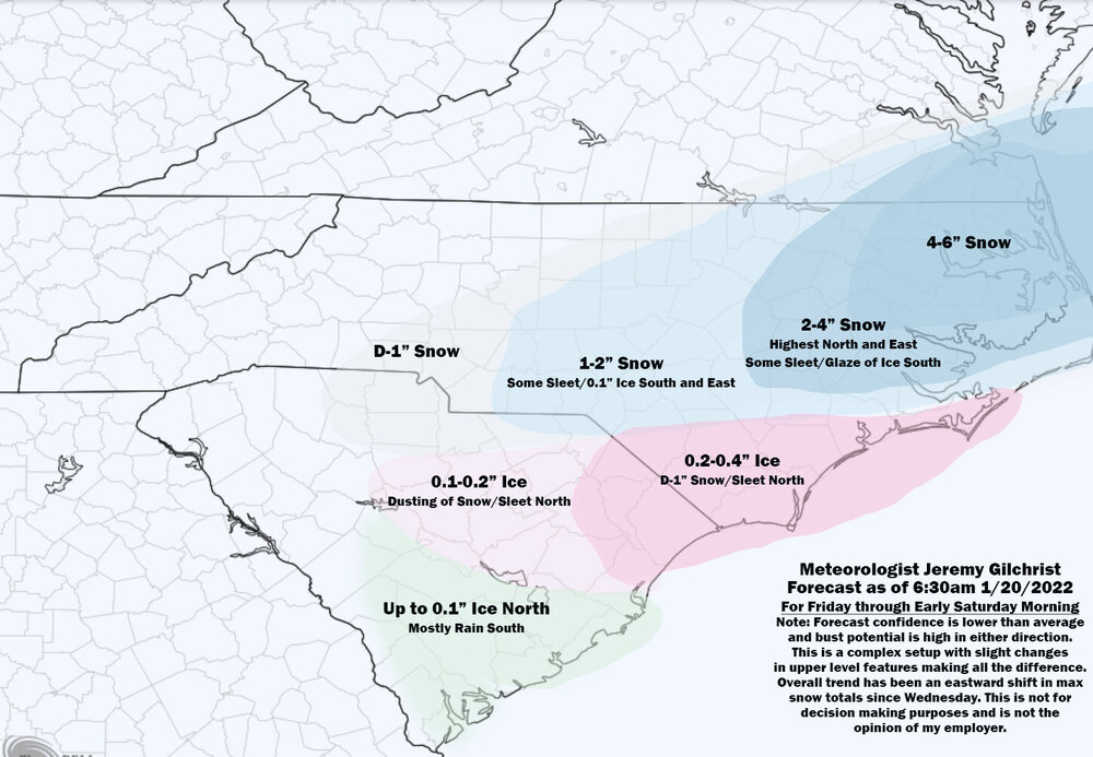
Call Map as of 7:45pm
-
January 20-22 “bring the mojo” winter storm threat
eyewall replied to lilj4425's topic in Southeastern States