eyewall
-
Posts
13,328 -
Joined
-
Last visited
Content Type
Profiles
Blogs
Forums
American Weather
Media Demo
Store
Gallery
Everything posted by eyewall
-
That was one of the worst heartbreakers for sure.
-
Southeast Sanitarium - Winter 23/24 Edition
eyewall replied to eyewall's topic in Southeastern States
You are spot on with that! -
Southeast Sanitarium - Winter 23/24 Edition
eyewall replied to eyewall's topic in Southeastern States
I believe being blanked two winters in a row would be a first for Raleigh. -
Yeah that storm had an inland track. I was on Long Island and we had 8 inches of snow followed by heavy rain. There was a flash freeze behind it which turned any remaining snow into a block of ice. Birmingham Alabama had twice the amount of snow we did from that one.
-
Southeast Sanitarium - Winter 23/24 Edition
eyewall replied to eyewall's topic in Southeastern States
Raleigh is on pace to join the 1000 day club in October 2024 since the last snowfall. -
Getting blanked 2 years in a row is just freaking awful. Raleigh will reach the 1000 day mark sometime in October and I believe 1044 days by the time the next meteorological winter begins.
-
Yeah at this point Raleigh has the climate of far southern Georgia so who knows.
-
Remember the advertised pattern shift? Well this is where we are at instead: Thursday Sunny, with a high near 65. Light and variable wind becoming southwest 9 to 14 mph in the morning. Winds could gust as high as 24 mph. Thursday Night Mostly clear, with a low around 44. Southwest wind 6 to 14 mph, with gusts as high as 21 mph. Friday Partly sunny, with a high near 62. Northwest wind 5 to 7 mph becoming south in the afternoon. Friday Night A slight chance of rain after 1am. Mostly cloudy, with a low around 44. Southeast wind 5 to 13 mph becoming southwest after midnight. Winds could gust as high as 20 mph. Chance of precipitation is 20%. Saturday Partly sunny, with a high near 55.
-
I would do that on the 50 yard line right now if it would work.
-
Considering NWS RAH is more concerned with fire weather during this time I am not impressed. It seems like this may end up more of a Virginia event.
-
Yep the advertised change has all but evaporated. Don't worry we'll get in time for weeks of cold rain in April.
-
Hopefully you will luck out. No way to know for sure now of course.
-
Yeah it is close in that 2/18 timeframe. We shall see.
-
Not 100% sure but based purely on climo.
-
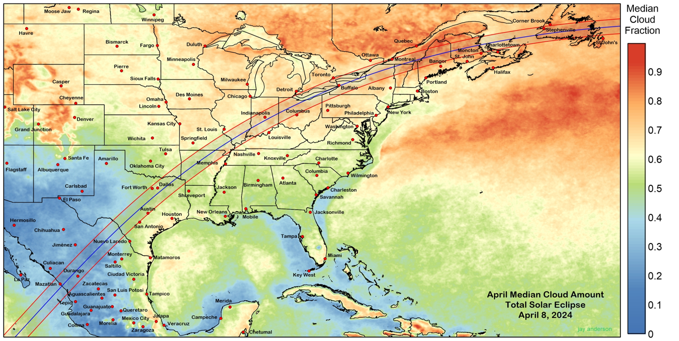
Basically these are percentages on the right so 0.9 equates to 90% (ie cloudy) and 0.1 would be 10% (mostly clear).

-
Southeast Sanitarium - Winter 23/24 Edition
eyewall replied to eyewall's topic in Southeastern States
ugh I am sorry. -
Too much risk of cloud cover in New England
-
I can tell you don't settle for 90% or even 99%! Get into totality as it is a different world! I will be in Texas for this one. In 2017 I was on the centerline in South Carolina.
-
Ski on ball bearings?
-
Southeast Sanitarium - Winter 23/24 Edition
eyewall replied to eyewall's topic in Southeastern States
All I can say is I am glad I took that trip to the mountains a few weeks ago when they had back to back snowfalls. -
I have to admit as pessimistic as I can be, getting blanked 2 years in a row was not what I expected.
-
Southeast Sanitarium - Winter 23/24 Edition
eyewall replied to eyewall's topic in Southeastern States
Count on it! -
This really has to be taken into account despite not wanting to talk about the elephant in the room around here.
-
Neutral would be good, but yeah it would make 4 out 5 winters La Nina years.
-
Southeast Sanitarium - Winter 23/24 Edition
eyewall replied to eyewall's topic in Southeastern States
Yep we could cross that 1000 day mark for sure.