eyewall
-
Posts
12,466 -
Joined
-
Last visited
Content Type
Profiles
Blogs
Forums
American Weather
Media Demo
Store
Gallery
Everything posted by eyewall
-
Yeah that is warm. wet bulb essentially right at freezing.
-
Ice storm for the US-1 corridor:
-
That run was better for sure. It weakened the Great Lakes low a lot more and after the 1st high retreats a second high is able to build in a little quicker. There is another little impulse for Tuesday as that occurs.
-
No I am saying it isn't looking great for this weekend's system to work out so that would take us to mid Feb in terms of chances after that. The parent high retreats quickly and the wedge won't hold nearly as long with that setup. ZR is self limiting as it is without a strong cold air feed maintaining itself.
-
Yep we are into mid Feb at this point. The setup just isn't enough here.
-
The problem remains the parent high is retreating as the storm hits. You won't maintain a good wedge when that happens and ZR will be self limiting. The next high doesn't build in until the system passes. This run looked even closer to in situ CAD.
-
The parent high is exiting as this occurs on the GFS which means shorter duration CAD. It is more of a Hybrid CAD event as opposed to classical. It is better than In-situ though.
-
I guess I am still looking for that makeup snow but at least ice does make for some good shots if there is a good amount of it.
-
I am not sure why everyone excited about ice lol.
-
Now this is some impressive video:
-
The GEFS Mean has ice:
-
The first wave goes north on the 12z GFS and then the CAD kicks in but the 2nd impulse dries out and goes a bit north after that. Fantasy range hasn't come in yet. It does not have a winter storm for next weekend in this neck of the woods.
-
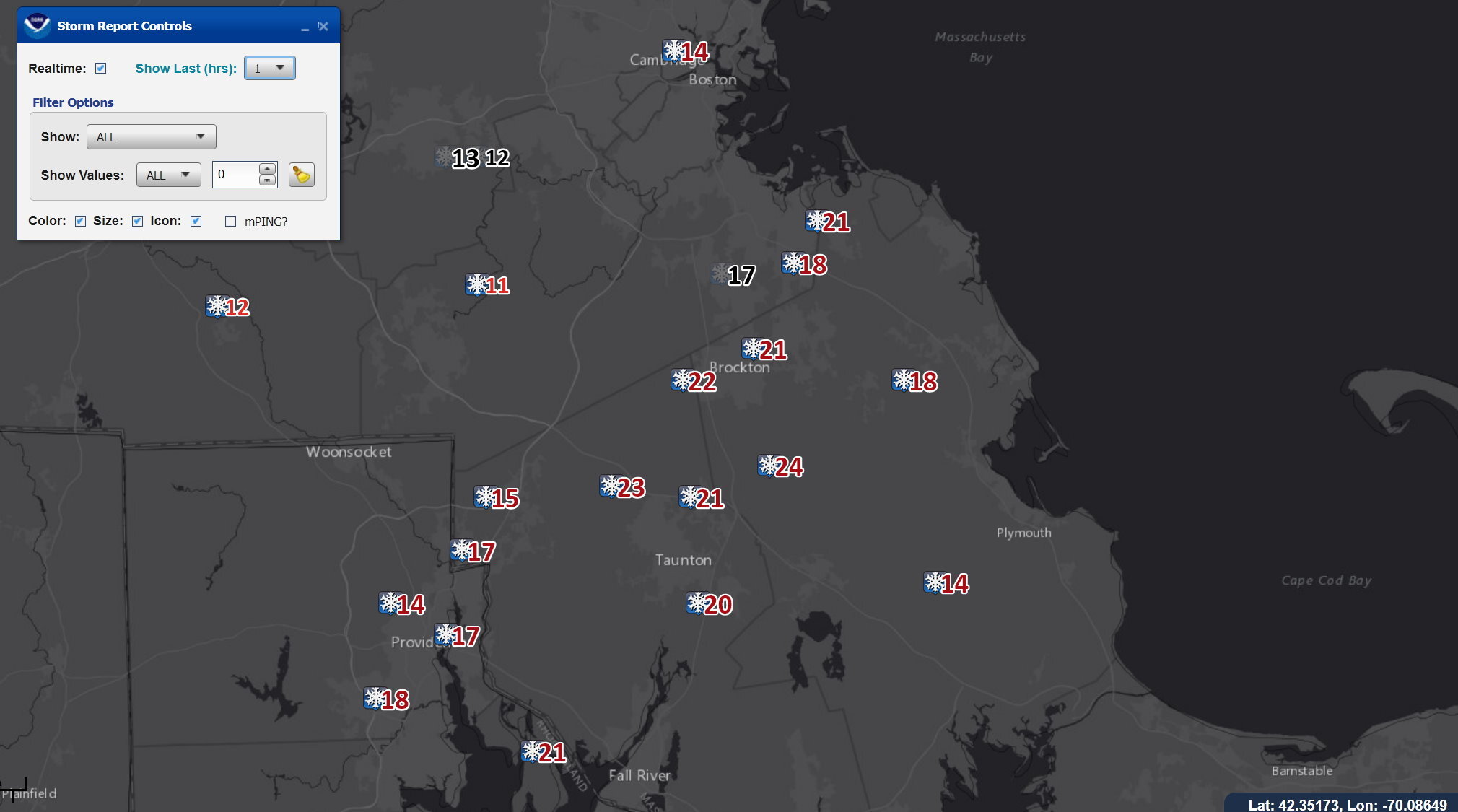
So did anyone make 30?
-
Congratulations to those in the bonus band east of Worcester.
-
The Taunton area will likely see totals in 28-32 range I think.
-
These just popped up on EDD. The 20's are from around 3pm or just after:

-
They have not that is correct. We have not had a classic Miller A pound the state this year.
-
yes they certainly can for sure.
-
Yeah I see what you're saying. We will see if that can battle the SE ridging enough to get the job done. Of course that would most likely be more in the way of mixed-p/ice if it does materialize, but that is certainly more of the norm when it comes to winter weather out here.
-
I am watching to see if that band centered to the east over Wareham takes over as the dominant. It certainly looks like it could.
-
Mostly a whiff for now but otherwise before that it is ridging and systems riding that to our north.
-
Somewhere roughly in that marked area has the best chance at 24-30 I think: Jackpot.mp4
-
The jackpot should be between Weymouth and Taunton in the end.
-
Neither the Euro or GFS shows anything promising in the foreseeable future. It appears the SE ridge is going to strengthen and kill us. The clock is ticking so hopefully that trends weaker as we go on.
-
Some spots should be over 20 now in that band as EDD reports show lots of 16-18's from an hour or more ago.