

eyewall
-
Posts
12,448 -
Joined
-
Last visited
Content Type
Profiles
Blogs
Forums
American Weather
Media Demo
Store
Gallery
Everything posted by eyewall
-
As I recall May 10th started in the middle of the day and lasted many hours after dark. All hope is definitely not lost. SWPC expects the high Kp numbers to persist after sunset. There will likely be a number of substorms as well.
-
Could add to the main one though. We shall see! May 10th was all M flares stacked up.
-
https://x.com/forecaster25/status/1844030900490895485 Buckle up! Even here in NC we may get something closer to the May 10th event.
-
They would get an initial surge but then a blowout tide as the center approached and winds turn offshore.
-
Ok definitely aiming for a rebound to Cat 5 for a bit.
-
Well I will eat my words. I expected additional weakening at 11am.
-
Right now I would bet the under on the expected landfall intensity which would be better news if that does happen. We shall see what adjustments are made shortly.
-
This storm is definitely feeling some decent shear now and I am not sure it will intensify again for the moment. Looks cloud tops have warmed in the northern half as well.
-
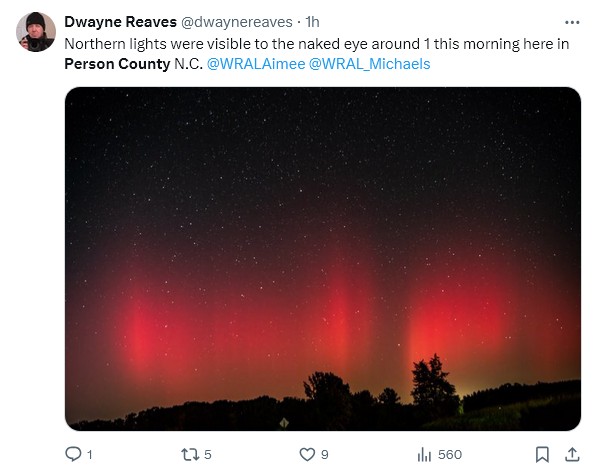
Apparently the aurora appeared in NC around 1am:
-
929mb and 145mph on the intermediate advisory. In my experience, the storm almost always weakens more than the official forecast during an EWRC. We will see how it rebuilds now that it has completed.
-
Again tonight I am seeing shots from New England of Aurora.
-
I could see it maxing out at 180 or 185 with perhaps an 890's pressure before degradation begins.
-
looks like it is trying to turn back eastward there for sure.
-
The question is will it run into the Yucatan at this point?
-
Aurora is out now in NNE.
-
Yeah I think the more determinant factor for Tampa is north or south of the bay more than anything.
-
A lot will also depend on eyewall replacement cycles.
-
I do not like that GFS run at all for Tampa and of course it will start making people nervous who were hit by Helene.
-
yes because hurricanes never happen in Florida
-
If this ends up south of Tampa it will be a blowout tide in the bay. Over and just north would be a record surge most likely.
-
There apparently was a request for a few hundred body bags now for western NC.
-
Just had a squarely Earth facing X9 flare. If it produced a solid CME buckle up!
-
Yesterday I helped load pallets of supplies for western NC to be taken out there by aircraft via operation airdrop. They are also going to portions of SC/TN as well. It became pretty clear this was going to end up being the real story of this hurricane. I am seeing stories of body recovery happening in riverbeds, homes, mudslides/debris flows, and even in trees where the water was that high. I also saw a story of horrific conditions in a long term care facility. That death toll is unfortunately going to climb even more.
-
Got this shot of a transient supercell passing through the North Hills region just after 2pm:
-
and 1000 missing.


