

sbnwx85
-
Posts
1,358 -
Joined
-
Last visited
Content Type
Profiles
Blogs
Forums
American Weather
Media Demo
Store
Gallery
Everything posted by sbnwx85
-
Freezing drizzle did a number on the overpasses and bridges around here this evening. Lots of crashes reported. Flurries mixing in.
-
Tack on another degree for the record books RECORD EVENT REPORT NATIONAL WEATHER SERVICE NORTHERN INDIANA 0421 PM EST THU DEC 26 2019 ...RECORD HIGH TEMPERATURE SET AT SOUTH BEND... A RECORD HIGH TEMPERATURE OF 63 DEGREES WAS SET AT SOUTH BEND TODAY. THIS BREAKS THE OLD RECORD OF 55 SET IN 1959.
-
I always say "if it ain't gonna snow in the winter it might as well be 60." SBN at 62 right now. I opened the back door to my apartment. Feels great!
-
Maybe our first ever “Snow Squall Warnings” could be issued in our neck of the woods?
-
Lock it in!
-
Record cold high set in South Bend...among many other locations I assume. RECORD EVENT REPORT NATIONAL WEATHER SERVICE NORTHERN INDIANA 440 PM EST TUE NOV 12 2019 ...RECORD COLD HIGH TEMPERATURE SET AT SOUTH BEND... A RECORD COLD HIGH TEMPERATURE OF 24 WAS SET AT SOUTH BEND TODAY. THIS BREAKS THE OLD RECORD OF 27 SET IN 1920.
-
Dunlap (between Goshen and Elkhart) had a report of 18 inches. I think that's the jackpot for Indiana for the event. I don't know of a time a lake effect event crushed Elkhart County like this. I ended with 6.4".
-
Sitting between bands now. The secondary band in Western St. Joseph County is very intense. I wonder if that will become the dominant band and move East. Dynamics must be incredible for lake effect snows right now. Sitting at 6.3” overall. Hoping the next band swings through overnight for another couple inches.
-
The band really getting its act together now. Probably some 2-3 inch per hour rates in there. My backyard went from 3 inches with the system to a total of 5.7” now. Still snowing but band is drifting East.
-
Some impressive totals for a Veterans Day storm. 287 NOUS43 KIWX 120129 PNSIWX INZ003>009-012>018-020-022>027-032>034-MIZ077>081-OHZ001-002-004-005-015- 016-024-025-121329- Public Information Statement National Weather Service Northern Indiana 829 PM EST Mon Nov 11 2019 ...SNOWFALL REPORTS THROUGH 8PM EST 11 NOVEMBER... Location Amount Time/Date Lat/Lon ...Indiana... ...De Kalb County... Auburn 3.1 in 0439 PM 11/11 41.37N/85.06W ...Elkhart County... 3 N Southwest 6.8 in 0445 PM 11/11 41.58N/85.93W 2 NW Goshen 6.0 in 0636 PM 11/11 41.60N/85.87W 1 WSW Goshen 6.0 in 0400 PM 11/11 41.58N/85.85W 3 ESE Elkhart 5.0 in 0445 PM 11/11 41.68N/85.92W 1 NNE Waterford Mills 5.0 in 0315 PM 11/11 41.55N/85.83W Goshen 5.0 in 0110 PM 11/11 41.58N/85.83W 3 WNW Goshen 4.5 in 0600 PM 11/11 41.59N/85.89W ...Fulton County... Akron 3.0 in 0308 PM 11/11 41.04N/86.03W ...Grant County... 4 WNW Hanfield 3.3 in 0640 PM 11/11 40.62N/85.66W Marion 1.0 in 0530 PM 11/11 40.55N/85.67W ...Huntington County... 1 ENE Huntington 3.0 in 0803 PM 11/11 40.88N/85.50W ...Jay County... 4 WNW Bryant 4.8 in 0803 PM 11/11 40.55N/85.03W ...Kosciusko County... 3 N North Webster 5.2 in 0702 PM 11/11 41.36N/85.70W ...La Porte County... 1 SSE Fish Lake 2.0 in 0521 PM 11/11 41.56N/86.54W ...Lagrange County... 2 NE Lagrange 6.5 in 0343 PM 11/11 41.67N/85.39W Shipshewana 5.8 in 0315 PM 11/11 41.68N/85.58W ...St. Joseph County... 2 ESE South Bend 4.0 in 0530 PM 11/11 41.67N/86.22W South Bend 3.5 in 1240 PM 11/11 41.68N/86.26W South Bend International Ap 3.1 in 0654 PM 11/11 41.70N/86.32W 3 SSE Mishawaka 3.0 in 1256 PM 11/11 41.63N/86.16W ...Steuben County... Orland 6.0 in 0404 PM 11/11 41.74N/85.17W 1 E Angola 4.8 in 0542 PM 11/11 41.64N/84.99W Angola 3.5 in 0311 PM 11/11 41.65N/85.00W 2 ENE Salem Center 2.7 in 0437 PM 11/11 41.59N/85.11W Fremont 2.5 in 1210 PM 11/11 41.73N/84.93W ...White County... Burnettsville 9.9 NNW 0.3 in 0100 PM 11/11 40.90N/86.65W ...Michigan... ...Berrien County... Stevensville 3.8 in 1200 PM 11/11 42.02N/86.53W 1 NNW Niles 3.3 in 0405 PM 11/11 41.85N/86.25W Benton Harbor 3.0 in 1253 PM 11/11 42.12N/86.45W ...Hillsdale County... 1 NE Moscow 9.0 in 0545 PM 11/11 42.06N/84.50W Hillsdale 7.0 in 0440 PM 11/11 41.93N/84.64W Jerome 6.0 in 0244 PM 11/11 42.03N/84.47W 1 NE Hillsdale 6.0 in 0237 PM 11/11 41.93N/84.63W ...St. Joseph County... 2 E Constantine 7.0 in 0500 PM 11/11 41.84N/85.63W Sturgis 3.7 in 1210 PM 11/11 41.81N/85.42W ...Ohio... ...Allen County... 1 WNW Lima 3.1 in 0816 PM 11/11 40.75N/84.13W ...Henry County... 1 NNE Napoleon 2.5 in 0802 PM 11/11 41.41N/84.12W ...Putnam County... 1 N Ottawa 4.8 in 0735 PM 11/11 41.04N/84.04W Columbus Grove 2.5 in 0628 PM 11/11 40.92N/84.06W Ottawa 0.5 in 0337 PM 11/11 41.03N/84.04W Observations are collected from a variety of sources with varying equipment and exposures. We thank all volunteer weather observers for their dedication. Not all data listed are considered official.
-
Moderate snow at the moment. Hoping the band stops its eastward progression and becomes stationary.
-
Lake effect band has come ashore in St. Joseph, MI.
-
Latest AFD from IWX: Current expectations are for decent inland penetration of banding tonight given strong northerly flow connected in with long axis of Lake Michigan and Lake Superior. With that said, hard to say if/where banding will hold in for a decent time for counties just south and east of the Winter Storm Warning (Elkhart/Kosciusko/Marshall/Fulton IN/Starke). Reduced visibilities, cold sfc temps, and additional accums will likely allow at least advisory level impacts to persist beyond the current 05z expiration in these counties. An upgrade to warning cannot be ruled out in Marshall/Starke/Elkhart counties if the southern end of more dominant band settles in for a time. Much higher confidence for additional 6" plus snow amounts and intense 1-2" snowfall rates in areas currently under a Winter Storm Warning. Latest guidance continues to suggest Berrien, far western Cass MI and St Joseph IN in line for longest duration in intense lake plume where localized totals will likely exceed a foot. Winds will also pick up on the western fringe which could create some blowing/drifting.
-
About 3" here. Now for the lake effect to set up. Expecting another 4 to 6 IMBY tonight. Possibly more if the band becomes stationary overhead. I'll post those updates and pictures in the lake effect thread. Absolutely fantastic for mid-November.
-
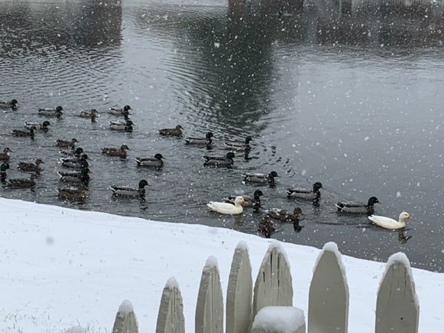
Best snows coming down now here. About 1.3 inches so far. The ducks aren’t thrilled.
-
HRRR showing poundtown for Berrien Co, MI and St. Joseph County, IN overnight. Single band that wobbles for about 12 hours.
-
Gimme gimme gimme!
-
A fun graphical interpretation of the event early next week from the TV station I work at.
-
In light of what appears to be a potentially impressive lake effect event in parts of the Great Lakes early next week I figured now is a good time to start up the region's lake effect thread for the winter. IWX hinting at the event beginning Monday.
-

Here comes winter -- October 28-November 1 Snowstorm Potential
sbnwx85 replied to Hoosier's topic in Lakes/Ohio Valley
Normally I love lake enhancement on this side of the lake in Indiana, but, as modeled, the wind off the "warm" lake keeps precip as rain here in South Bend. Oof. Oh well, it is October after all. I'll enjoy my rain/snow mix. -
Here comes winter -- October 28-November 1 Snowstorm Potential
sbnwx85 replied to Hoosier's topic in Lakes/Ohio Valley
Obligatory "It's nice to have something to track" comment. -
First MD of the event is out: https://www.spc.noaa.gov/products/md/md1717.html
-
I haven't ever started a new thread before so a mod can feel free to change something if needed. This has been discussed in the short/medium range severe thread but it's not everyday we get a 10% hatched TOR threat from SPC in this region...especially in August. There's a chance this becomes an impressive, if not small, regional outbreak so let's get the party started. Discussion also mentions possible upgrade to moderate risk.


