sbnwx85
-
Posts
1,316 -
Joined
-
Last visited
Content Type
Profiles
Blogs
Forums
American Weather
Media Demo
Store
Gallery
Everything posted by sbnwx85
-
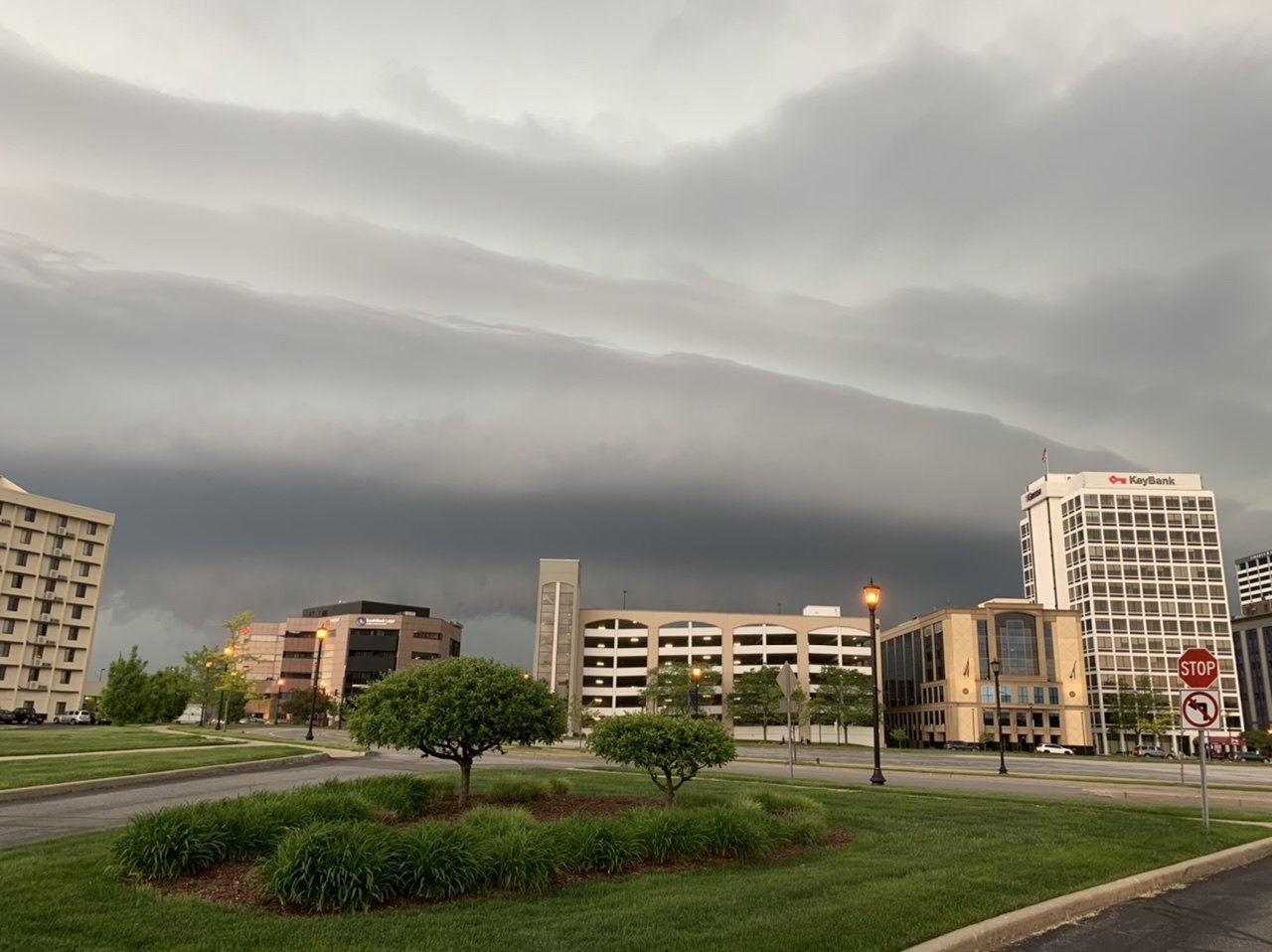
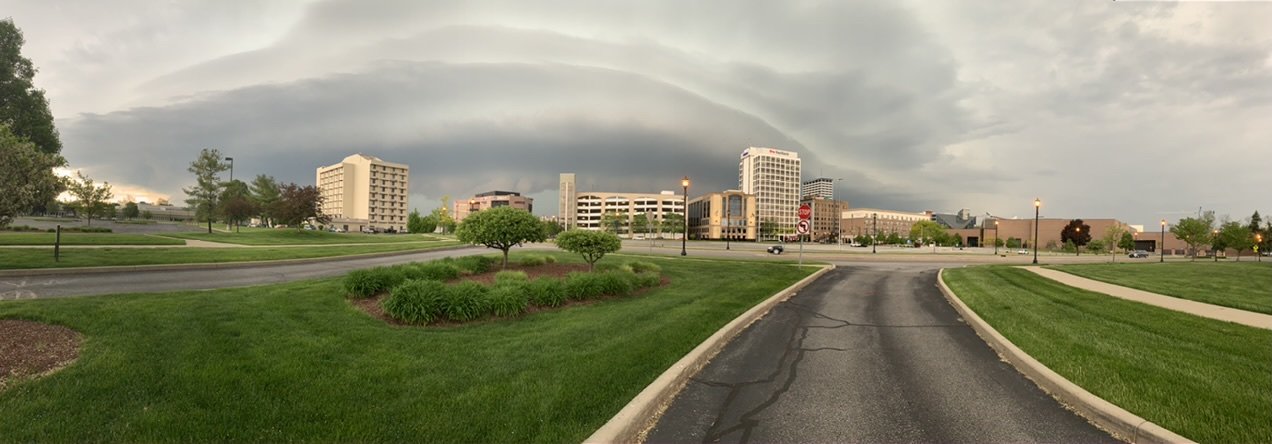
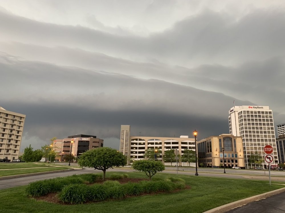
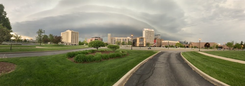
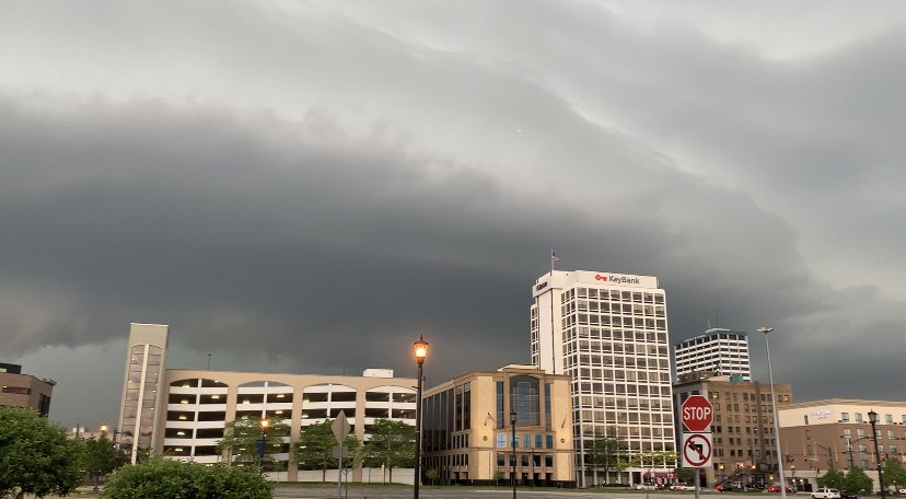
The wind was really howling as the shelf cloud moved overhead! I hung out in my car in an empty lot away from trees and power lines just in case.
-
Just had a nice cell move through South Bend about 40 minutes ago. Pretty shelf cloud followed by gusty winds, small hail and torrential rains.
-

May 13-19 Severe/Heavy Rain threats
sbnwx85 replied to Tim from Springfield (IL)'s topic in Lakes/Ohio Valley
Mesoscale Precipitation Discussion 0190 NWS Weather Prediction Center College Park MD 522 PM EDT Thu May 14 2020 Areas affected...Southern IA...far northern MO Concerning...Heavy rainfall...Flash flooding possible Valid 142120Z - 150200Z SUMMARY...Storms training over areas that received heavy rainfall earlier today could pose a flash flood threat through late this afternoon into early this evening. DISCUSSION...The GOES-16 visible loop showed a line of towering cumulus forming along and just north of a stationary boundary across portions of southern IA. The formation zone lies on the northern edge of the instability gradient, with SBCAPE over 3000 J/KG over northernmost MO into far southern IA. The storms are developing on the northern edge of the better moisture source, and the combination of moisture and instability allowed storms over Atlantic and Guthrie Center counties to produce hourly rainfall rates in excess of 2.25 inches (though the DMX HCA product does indicate the potential for hail contamination) within the last 90 minutes. The 850/300 mb mean wind is generally aligned with the propagation vectors across southern and central IA, which could foster an environment conducive to continued training. However, without a clear source of lift over the boundary, it is not clear just how extensive the convection becomes along and south of the boundary through 15/00z. Both the latest HRRR/parallel HRRR solutions do have a handle on the initial convective placement, but do not necessarily have a handle on the intensity of the rainfall with the storms themselves. Each model shows a general increase in coverage as higher instability is slowly advected along the front into southern IA. The best coverage (based on the simulated radar imagery from the HRRR/parallel HRRR is expected across southwest IA, where an area of 1.00/2.00 inches of rainfall occurred in earlier convection. Storms training over this area could produce an additional 1.00/2.00 inches or train, which pose a flash flood threat through late afternoon and early evening. Since the coverage of storms in the area that received heavy rainfall earlier today is still unclear, flash flooding is considered possible. -
May 13-19 Severe/Heavy Rain threats
sbnwx85 replied to Tim from Springfield (IL)'s topic in Lakes/Ohio Valley
Pretty good bounded weak echo region now. -
May 13-19 Severe/Heavy Rain threats
sbnwx85 replied to Tim from Springfield (IL)'s topic in Lakes/Ohio Valley
WPC expanded the excessive rainfall moderate risk into southeast Iowa and basically the northern half of IL. Good write-up below. Excessive Rainfall Discussion NWS Weather Prediction Center College Park MD 1223 PM EDT Thu May 14 2020 Day 1 Valid 12Z Thu May 14 2020 - 12Z Fri May 15 2020 ...THERE IS A MODERATE RISK OF EXCESSIVE RAINFALL FROM CHICAGOLAND TO NORTHERN MISSOURI... ...Moderate Risk Area... A northern stream system skirting across the Midwest, with a developing upper level jet streak during convective maximum, 21-06Z, will interact moderate instability along a slow moving frontal zone, to produce a multi-hour heavy rain event this afternoon/evening. Synoptic deep layer forcing becomes maximized along a zone from northern Missouri and southern Iowa toward northern Illinois and southwest lower Michigan. Many model QPFs align here, such as the NAM, NAM Nest, WRF-NMMB, and recent HRRR runs. The WRF-ARW is a bit of an outlier in how much southward propagation it produces, ending up considerably south of the rest... but the WRF-ARW2 perhaps represents a more resonable southward adjustment that may occur as a result of outflow from early-morning convection. Thus, there are still some placement challenges, especially toward Chicago where the lake breeze may also act to inhibit the northward rebound of instability later on today. Northern Illinois is, however, more hydrologically vulnerable - having received 0.50 to 1.50 inches of rain this morning. Parts of the Davenport area also received some local amounts up to two inches. Aside from the early-day event, much of the region has been running below normal on precipitation recently, with fairly dry soils. Thus a second challenge is whether the evening event is likely to produce impacts consistent with the Moderate Risk category. But there do appear to be enough overlapping factors to support Moderate Risk. Inflow of unstable low level air near and atop the effective surface front and other outflow boundaries will increase to 30-40 knots late this afternoon, with deep layer flow becoming quite parallel to the boundaries. We could see a several hour period of training, causing what is otherwise an average combination of PW and CAPE to produce a few spots of higher-end rainfall totals. The NMMB even signals a small 3-inch / 1-hour amount in Illinois, and the NAM Nest signals local 3 to 4 inch in 3 hour totals, indicative of what could occur. This may lead to numerous flash floods and isolated higher-end impacts. Thanks to the WFOs and RFCs for helping shape the updated Moderate Risk contour. -
2.5” of cement so far. Absolutely gorgeous January morning. Nice fat flakes coming down.
-
I had 6 inches here on Veterans Day and would be happy to book end the season with another six incher on April 17. Would be my two biggest snows this "winter".
-
IWX just expanded the Winter Wx Advisory to include its Michigan counties. Calling for 2-5 in Michigan counties. 3-6 south of there and 4-7 further south of that.
-
Winter doesn't start until around mid-April anymore. In all seriousness, if trends continue it wouldn't be a surprise to see a relatively narrow swath pick up 6 to 8 inches of snow out of this. Should be plenty of moisture to work with. The snow falling at night/morning will help with accumulations, too.
-
What's the record for most Winter Weather Advisories in a season?
-
I let out a very Ron Swanson giggle when I saw the GFS.
-
Storms to my west being warned for quarter size hail and 60 mph winds.
-
Yup. And already seeing some development just east of the lake shore. Amazing what a cold Lake Michigan does
-
It'll be interesting to see what happens when the best forcing comes onshore from Lake Michigan into SW MI and N IN. Will the line fill in quickly or will it be a swing and a miss?
-
I'm wondering if the gap over southern Lake Michigan will fill in before the line moves through my area. I'd be okay not dealing with severe weather tonight (never thought I'd say that. I think I'm getting old).
-
New Severe Tstorm Watch for N IL, NW IN and extreme E IA. URGENT - IMMEDIATE BROADCAST REQUESTED Severe Thunderstorm Watch Number 82 NWS Storm Prediction Center Norman OK 525 PM CDT Tue Apr 7 2020 The NWS Storm Prediction Center has issued a * Severe Thunderstorm Watch for portions of Far east-central Iowa Northern Illinois Far northwest Indiana Lake Michigan * Effective this Tuesday afternoon and evening from 525 PM until 1100 PM CDT. * Primary threats include... Scattered large hail and isolated very large hail events to 2.5 inches in diameter possible Isolated damaging wind gusts to 65 mph possible A tornado or two possible SUMMARY...A couple supercells may evolve into an east-southeast progressing cluster along a cold front from far eastern Iowa through northern Illinois this evening. Large hail should be the primary hazard. The severe thunderstorm watch area is approximately along and 35 statute miles north and south of a line from 75 miles west of Rockford IL to 15 miles north of Valparaiso IN. For a complete depiction of the watch see the associated watch outline update (WOUS64 KWNS WOU2). PRECAUTIONARY/PREPAREDNESS ACTIONS... REMEMBER...A Severe Thunderstorm Watch means conditions are favorable for severe thunderstorms in and close to the watch area. Persons in these areas should be on the lookout for threatening weather conditions and listen for later statements and possible warnings. Severe thunderstorms can and occasionally do produce tornadoes. && OTHER WATCH INFORMATION...CONTINUE...WW 81... AVIATION...A few severe thunderstorms with hail surface and aloft to 2.5 inches. Extreme turbulence and surface wind gusts to 55 knots. A few cumulonimbi with maximum tops to 500. Mean storm motion vector 28035. ...Grams
-
Biggest hail I've ever seen was golf ball size. Quite frankly, that's big enough.
-
Mid-week potential of something somewhere
sbnwx85 replied to Chicago Storm's topic in Lakes/Ohio Valley
Lake effect overnight and this morning “saved” this event for me. Ended with 5.3”. Bring on Spring! -
Mid-week potential of something somewhere
sbnwx85 replied to Chicago Storm's topic in Lakes/Ohio Valley
2.3 inches so far. Woo. It’s getting to the point where I don’t believe the atmosphere is capable of producing a snow of more than 3 inches. -
Mid-week potential of something somewhere
sbnwx85 replied to Chicago Storm's topic in Lakes/Ohio Valley
Enjoy. -
Mid-week potential of something somewhere
sbnwx85 replied to Chicago Storm's topic in Lakes/Ohio Valley
Ripping. -
Mid-week potential of something somewhere
sbnwx85 replied to Chicago Storm's topic in Lakes/Ohio Valley
Heavy, wet snow. Dusting on the grass and cars. Radar looks good for my area. -
Mid-week potential of something somewhere
sbnwx85 replied to Chicago Storm's topic in Lakes/Ohio Valley
The year of Winter Weather Advisories continues. -
Mid-week potential of something somewhere
sbnwx85 replied to Chicago Storm's topic in Lakes/Ohio Valley
Holding my breath at this point. -
Mid-week potential of something somewhere
sbnwx85 replied to Chicago Storm's topic in Lakes/Ohio Valley
It's not lost on me that the loss most are experiencing from this storm is my gain...and for that I'm sorry. Please accept my condolences.