sbnwx85
-
Posts
1,318 -
Joined
-
Last visited
Content Type
Profiles
Blogs
Forums
American Weather
Media Demo
Store
Gallery
Everything posted by sbnwx85
-
I'm certainly mentally prepared for a cold rain here...hopefully followed by some lake-effect.
-
Monster run on the GFS. Lake response looks good, too.
-

Winter 2021-22 Short/Medium Range Discussion
sbnwx85 replied to Chicago Storm's topic in Lakes/Ohio Valley
We'll get a big dog in April. -
December 15th-16th Warmth, Wind, and Severe Threat
sbnwx85 replied to Geoboy645's topic in Lakes/Ohio Valley
What a lovely Maycember we are having. -
Impressive couplet on the storm crossing the Illinois River into Naples.
-
TOR Warning all the way up in Iowa north of the Watch. Impressive!
-
Meteorologist Andrew Whitmyer in South Bend posted this interesting fact.
-
Thought I was seeing lightning but it’s transformers blowing. Leaves on trees and heavy snow don’t mix.
-
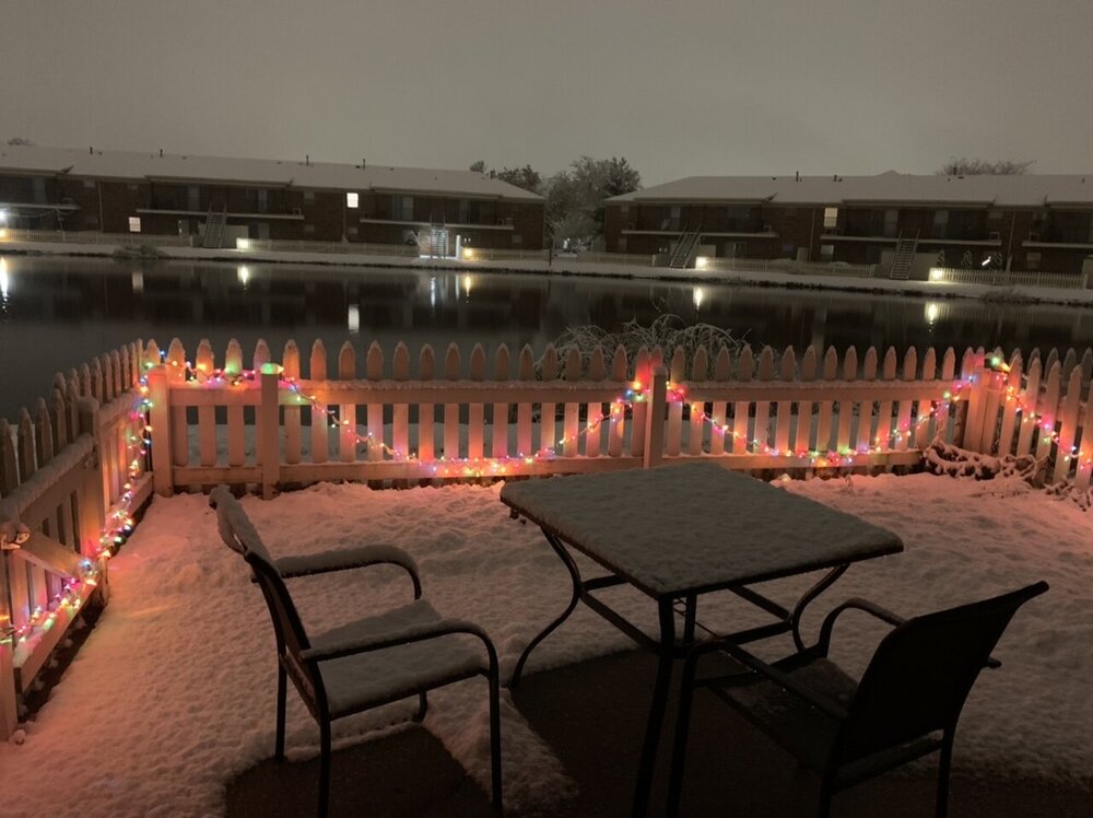
Had dustings the last couple of mornings but that lake effect band has dropped a quick inch or so. Heavy wet stuff sticking to everything. We picked a good night to put up the Xmas lights!
-
I was going to ask if storms could develop if the cap can erode after sunset. Latest SPC discussion answers that with a "maybe?" Mesoscale Discussion 1492 NWS Storm Prediction Center Norman OK 0735 PM CDT Wed Aug 11 2021 Areas affected...Eastern IA...Northern IL...Far Southern WI...Northwest IN...Southwest Lower MI Concerning...Severe potential...Watch possible Valid 120035Z - 120200Z Probability of Watch Issuance...40 percent SUMMARY...Storm coverage is expected to increase this evening, with at least an isolated severe threat into late tonight. New watch issuance is possible by 01-02Z. DISCUSSION...Earlier supercells over eastern IA, southwest WI, and northwest IL have weakened over the last hour, likely due to generally weak large-scale ascent and modest capping noted in 00Z DVN sounding. However, regional soundings and VWPs also depict a rather strong southwesterly low-level jet across the area, which is generally forecast to intensify further tonight as it veers to a more westerly direction. Storm coverage is expected to increase with time later this evening within this warm advection regime, as airmass recovery continues across northern IL/IN and a surface boundary moves southeastward across the region. Even if storms remain somewhat elevated tonight, steep midlevel lapse rates and rich low-level moisture will still support large MUCAPE, with sufficient deep-layer shear for some organized storm structures. A mix of cells and clusters will be possible, posing a threat of at least isolated hail and damaging wind. A conditional tornado threat will also be present with any storm that can become rooted in the boundary layer, which would be most likely for a few hours this evening before MLCINH becomes increasingly prohibitive late tonight. While some uncertainty remains regarding the convective evolution and coverage of the severe threat later tonight, watch issuance is possible by 01-02Z, in advance of the expected increase in storm coverage. ..Dean/Goss.. 08/12/2021
-
Whatever happens here’s your reminder to charge the phone/iPad tonight just in case.
-
SPC pushes moderate risk into Western Michigan/extreme N. Indiana. Zoomed in view.
-
Skilling mentions the D-word...https://www.facebook.com/photo?fbid=380591763425773&set=pcb.380591860092430 DERECHO THREAT IN CHICAGO AND THE MIDWEST WEDNESDAY NIGHT The transition to a cooler pattern may get underway with an atmospheric bang Wednesday night. While a few scattered/isolated, low coverage t-storms are possible during the day Wednesday---IT'S WED NIGHT WHEN A MORE SIGNIFICANT SEVERE WEATHER THREAT APPEARS TO BE TAKING SHAPE. A classic"northwest flow" situation is taking shape. That's an atmospheric setting which threatens several bowed lines of severe t-storms--even the potential for a "derecho"--a fast, moving damaging line of t-storms which races southeastward beneath a powerful "northwesterly jet stream" and infuses the fast moving storms with wind energy that can produce an extended path of damage. While many details remain to be firmed up, it would appear the period from midnight Wed night to 4 am Thursday morning appears to be the current focus of concern. That's when a fast moving squall line could sweep out of Wisconsin into northern Illinois and northwest Indiana. The latest NWS STORM PREDICTION CENTER severe weather risk forecasts for the Wed/Wed night period are posted--as are a series of RPM model hourly panels which track the potential squall line from the North Woods of Wisconsin southward into the Chicago area. Stay tuned! More to come here and on our WGN weather programs tonight (Tuesday night) and Wednesday. This is an early "head up".
-
I haven't started a thread since lake-effect season, so maybe this will bring some luck? I love a good night time squall line. Best severe chances probably wane as the MCS approaches my neck of the woods due to timing, but I'm going to stay up to find out. I don't go to bed until 2 AM most nights anyway. KIWX Timing is also a point of uncertainty as it will depend on the speed of the MCS. At this point timing on when the MCS could enter the far NW/N corner of the CWA range from 03z to 09Z. Convective parameters across the area during that timeframe will remain conducive to severe weather despite the overnight timing. MLCAPE is forecast to range 2000-2500 J/kg while 0-6km shear starts out near 30kt before ramping into the 40-50kt range. While damaging wind gusts will be the greatest threat from this MCS, hail and an isolated tornado can`t entirely be ruled out. Given PWAT values increasing into the +2SD of climatology and a window of MBE Velocities in the 10-15kt range also keeps the risk of heavy rain leading to flooding in the mix. Timing on when the MCS will exit the area ranges from 12Z to 15Z Thursday. Day 2 Convective Outlook NWS Storm Prediction Center Norman OK 1228 PM CDT Tue Jul 27 2021 Valid 281200Z - 291200Z ...THERE IS AN ENHANCED RISK OF SEVERE THUNDERSTORMS EAST-CENTRAL MINNESOTA INTO CENTRAL AND SOUTHERN WISCONSIN... ...SUMMARY... Thunderstorms associated with severe wind gusts, large hail to very large hail, and a couple tornadoes will be possible Wednesday afternoon into Wednesday night across parts of the Upper Midwest and extending into the southern Great Lakes region. ...Upper Midwest into the southern Great Lakes... A cluster or two of showers/thunderstorms may be ongoing Wednesday morning from northern MN southward into perhaps the IA/WI border vicinity within a warm advection regime. This activity will likely dissipate by the late morning. A subtle mid-level disturbance, cresting the mid-level ridge centered over the central Great Plains, will move eastward into western MN by late afternoon. A warm frontal zone will become draped from the southwest Great Lakes northwestward through WI into northern MN. Strong heating and a very moist boundary layer will lead to a very unstable airmass developing by mid afternoon over the Upper Midwest (2500-4000 J/kg MLCAPE, locally higher). Suite of convection-allowing models show an initial cluster of supercells will probably develop during the late afternoon into the early evening. Large to very large hail, severe gusts, and a couple of tornadoes are possible. Enlarged hodographs near the warm front will favor strong mesocyclones but it is unclear how much of a tornado risk will ultimately develop due to storm-scale interactions. Nonetheless, an initial cluster of storms will likely grow upscale into a forward-propagating severe MCS over the western Great Lakes during the evening with localized intense gusts (75+ mph) possible with HP supercell to QLCS transitions or with the more pronounced bowing segments. It seems plausible this MCS will move across southern Lake Michigan into the southern Great Lakes during the overnight. The coverage/intensity of gusts will probably lessen with time as the squall line encounters weaker buoyancy during the pre-dawn hours. ..Smith.. 07/27/2021
-
June 20th, 2021 Severe Weather Event
sbnwx85 replied to HillsdaleMIWeather's topic in Lakes/Ohio Valley
It’s the Chicago TV market so that’s something? Anyway, probably need that Tornado Watch soon. -
June 20th, 2021 Severe Weather Event
sbnwx85 replied to HillsdaleMIWeather's topic in Lakes/Ohio Valley
Update from IWX. A couple hours old now but shows they’re confident storms will develop as the MCV approaches. It’s been warm and muggy with sunshine all day. The webinar indicates US 30 as the most likely area for tornadoes, but the location of the warm front depicted in the SPC MD would make me think the state line might be a better option? -
June 20th, 2021 Severe Weather Event
sbnwx85 replied to HillsdaleMIWeather's topic in Lakes/Ohio Valley
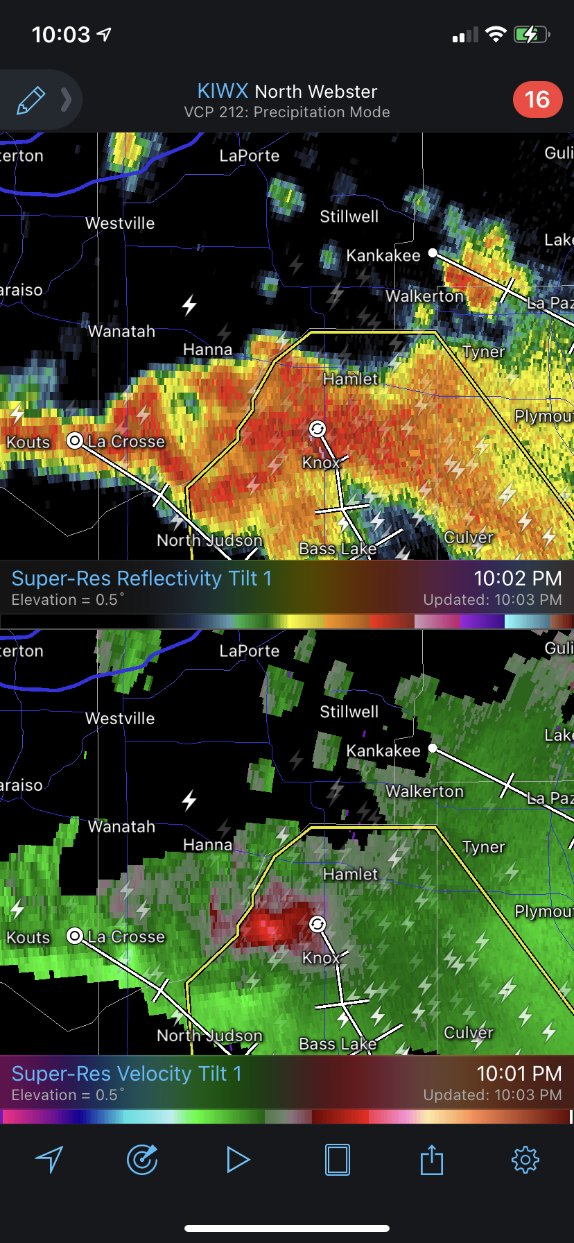
Nice downburst signature near Knox, IN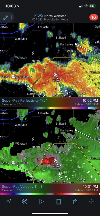
-
June 20th, 2021 Severe Weather Event
sbnwx85 replied to HillsdaleMIWeather's topic in Lakes/Ohio Valley
Yeah, that looks nasty. Not chasing it because it is terrible terrain. Way too many trees for me. -
I'm guessing this is it...
-
Just commemorating the first IWX SVR Warning of 2021...on June 18th. We did it. Congrats, everyone.
-
Ready to stay up late...or get up early...for the decaying MCS coming through Friday morning.
-
Might the IWX warning-less streak come to an end tonight?
-
There was a lake-breeze-induced funnel cloud that formed out of a small thunderstorm in LaPorte County around 2:30 PM CDT today. Edit: Not my photo. It was sent to my TV station by a viewer.
-
Raining pretty good here today. Amazing how the IN/MI state line is basically the mark between drought and no drought.
-
IWX also had its first spring with zero warnings. Brutal.