

sbnwx85
-
Posts
1,317 -
Joined
-
Last visited
Content Type
Profiles
Blogs
Forums
American Weather
Media Demo
Store
Gallery
Everything posted by sbnwx85
-
First and final call: 14.5". Gets us near our average for the season so far.
-
Slight bump northwest with overall total on GFS.
-
IWX round 1: Round 2:
-
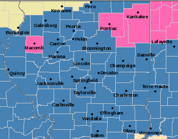
Posting for posterity's sake seeing McDonough County highlighted in pink around a sea of blue. It's just fun.
-
Not gonna lie...a little nervous being on the northern edge of a foot of snow. Anymore southeast shifts and I'm in "low-end warning criteria". Hoping to stop the bleeding with the 00z runs tonight.
-
Settling on the fact it’s most likely the heaviest snows with this entire event will be just to my south. Still can’t be upset with over a foot though.
-
Mine has definitely already been impacted. Getting to and from work could be interesting this week. Thankful it’s only a 5 minute drive but I can’t call off.
-
Yeah, I was wondering what the deal was because Kuchera still puts SBN at 30 inches this run. I’m still trying to pick up my jaw off the floor.
-
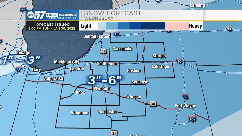
Unless something changes drastically Wednesday alone should put down 6+ locally.
-
For the record I work at one of the tv stations in South Bend (in the news department…not a met) and I’m happy to say it’s not this station.
-
They may consider an advisory. Jackpot zone on both GFS and Euro about two counties south of me. Not that I would complain about a foot and a half of snow over two days. I think my all time personal record is 21ish inches New Years Blizzard of ‘99.
-
Just a slight wobble back north overall on the snow map compared to 6z on the latest GFS run.
-
GFS trending south the last couple of runs. Still monster totals.
-
In all my amateur winter storm tracking days I can’t recall seeing a solution like the GFS is showing. Euro seems more plausible just based on what my unskilled eye has seen before but someone with more knowledge can weigh in. Hoping the GFS is onto something because I’d love to see a 30 burger next week.
-
Classic GFS vs Euro. Who will win this round?
-
Keeping with the theme.
-
Yeah it won’t be a very productive weekend with all the model watching.
-
The 00z GFS run would be a dream come true for me and many other snow lovers. Snow starts at about 2 am Wednesday here and doesn’t stop until Noon on Thursday. Lock it in.
-
Maybe I've been oblivious until now...but College of DuPage is now offering some Euro data for free including Kuchera snow rates. The 12z is just now running on the site, but it's resource for those that want to see those maps and don't want to pay for them. https://weather.cod.edu/forecast/
-

Winter 2021-22 Short/Medium Range Discussion
sbnwx85 replied to Chicago Storm's topic in Lakes/Ohio Valley
Taking a page from the SBN book. -
Got a couple inches of fresh snow this morning. Hopeful for about another 4 inches from the lake tonight thru Tuesday night. That could bring total since Saturday night to 10 inches, but now I'm dependent on lake-effect which is like depending on one-ply toilet paper. You hope it holds together.
-
I’d eyeball about 3.5 inches around Mt. Prospect. Looks like about the same or maybe a touch more back home in Mishawaka. Next clipper and lake effect look promising on the HRRR and RAP.


