sbnwx85
-
Posts
1,954 -
Joined
-
Last visited
Content Type
Profiles
Blogs
Forums
American Weather
Media Demo
Store
Gallery
Everything posted by sbnwx85
-
It’s raining pretty hard here. Kinda neat…
-
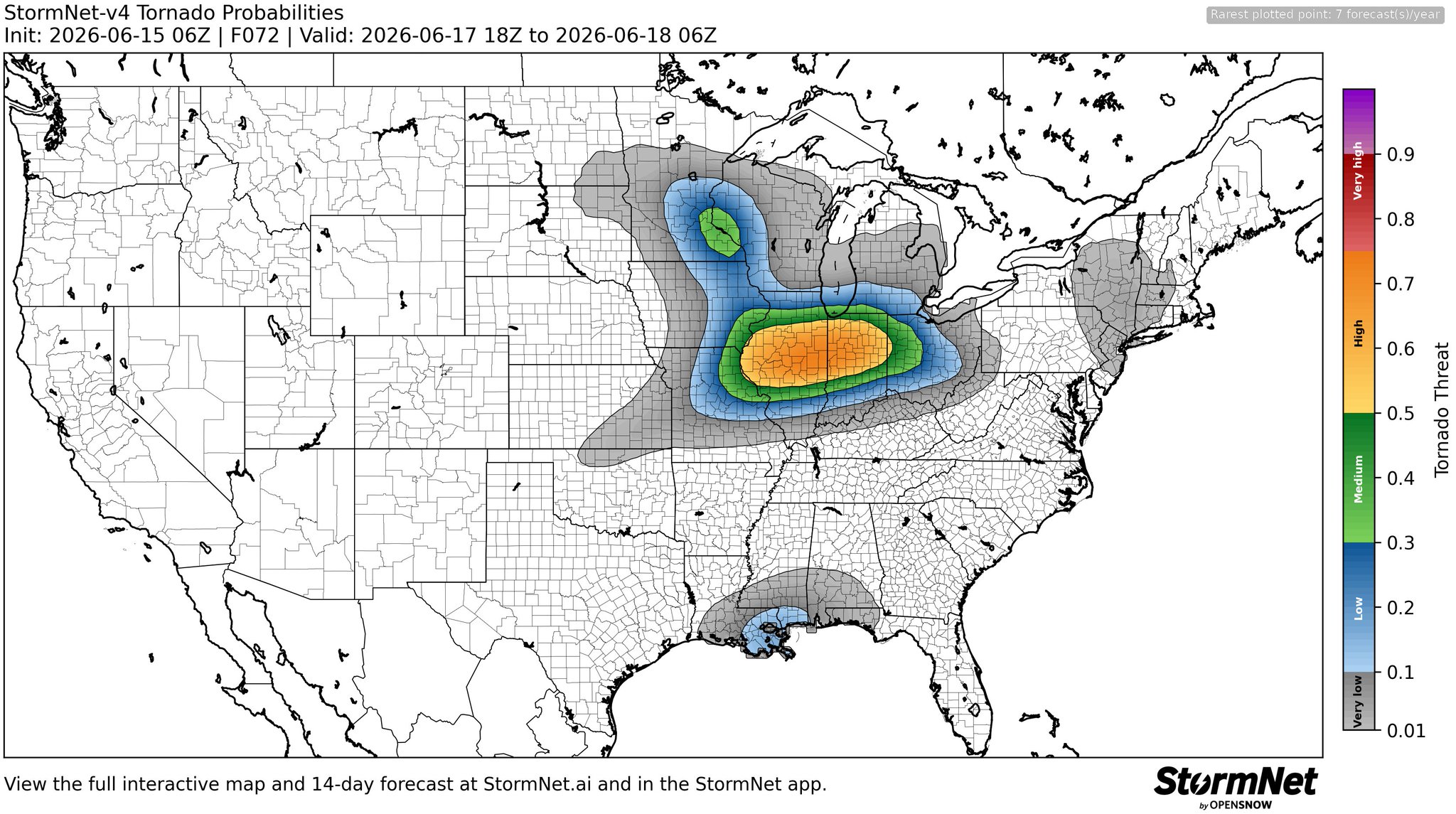
From 10 percent double-hatched to two percent.
-
Re: IWX's forecast area... I think along and south of IN State Road 14 has a shot at a strong tornado. Maybe a spin-up along and south of U.S. 30. My biggest concern in South Bend is whether my basement gets water.
-
It’s over for us up here.
-
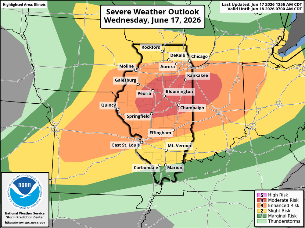
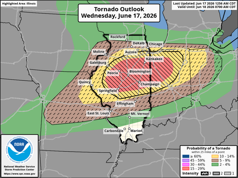
SPC not making many changes to the Day 1 forecast except extending the 10% tornado risk and CIG 2 north. There maybe more small changes but it’s too late to dig into it. A great read below. Day 1 Convective Outlook NWS Storm Prediction Center Norman OK 1256 AM CDT Wed Jun 17 2026 Valid 171200Z - 181200Z ...THERE IS A MODERATE RISK OF SEVERE THUNDERSTORMS OVER ILLINOIS AND INDIANA... ...SUMMARY... An outbreak of severe thunderstorms is expected today, with primary threat centered over Illinois and Indiana. Several intense tornadoes, swaths of damaging gusts over 75 mph and damaging wind-driven hail will all be possible. ...IL...IN...MO...OH... An intense mid and upper level jet will nose southeastward across the Midwest today, with a prominent leading disturbance moving out of IA and into IL through midday. Severe storms are likely to be associated with this early wave as a southwesterly low-level jet increases to 60 kt and rapidly bring instability into the area. This initial activity will bring damaging winds to eastern IA and northern/central IL. This system is expected to weaken later in the afternoon, but some remnants will move across IN. Ahead of this early activity, a warm front will push north across IN and OH. New severe storm development, perhaps transitioning out of the remnant activity and/or forming near the warm front, is possible across northern IN into northwest OH. Shear profiles will be excessive, with tornado risk only conditional on minimal instability being present. The result may be a isolated tornadic supercells. To the west, the air mass across northern MO, IL, and into central IN will easily recover and rapidly destabilize due to strong southwest winds. A 60+ kt low-level jet is forecast, with notably strong winds around 700 mb as well (surface to 3 km shear values may exceed 60 kt). A plume of 65-70 F dewpoints will likely extend from central MO into IL and western IN in the 21-00Z time frame, contributing to 2000-3000 J/kg MLCAPE. A broken line of supercells is likely to develop and mature roughly from northern IN into central IL and MO around 21Z and spreading east/southeast through early evening. Given the clearly supercellular shear profiles, linear storm mode is unlikely for most of the event. Long-tracked supercells producing tornadoes and damaging hail are likely. Finally, the warm frontal position will need to be monitored near the IN/MI border. Even if instability is elevated into MI, extreme shear and lift may still yield damaging winds and even a tornado risk. As such, probabilities have been increased into far southern Lower MI. ...Upper TX Coast into the northern Gulf Coast... The NHC forecast shows Potential TC One moving into southwest LA by 00Z. Wind fields associated with this system will strengthen out of the south ahead of it, resulting in areas of strong low-level shear from TX into southern LA, and possibly into MS. Mid to upper 70 F dewpoints will contribute to modest CAPE values, supporting embedded stronger cells with tornado potential. ..Jewell/Weinman.. 06/17/2026
-
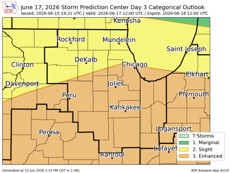
LOT’s AFD goes crazy Wednesday: An unusually powerful shortwave trough is progged to race east-southeastward into the upper Midwest and western Great Lakes Wednesday into Wednesday evening. Model guidance is in good agreement on the synoptic scale with 500 mb heights progged to be 3-4 standard deviations below normal for mid June. At the sfc, an associated low pressure that could threat all- time monthly record for June is expected to develop across Wisconsin and eventually move into lower Michigan. Unsurprisingly, the kinematic fields with such an anomalously strong system are also nearing the upper echelons of what we see this time of year in the Midwest. All of this to say that synoptically, the ingredients are coming together for a potentially dangerous outbreak of severe thunderstorms and potentially long-tracked, intense tornadoes. On the mesoscale, there are naturally greater uncertainties regarding precisely where (and to a lesser extent, if) the overlap of exceptionally strong deep and low level shear and moderately strong instability will take place. SPC`s latest SWODY2 highlights areas south of I-80 in our CWA with a rare day 2 moderate risk (level 4 of 5) for Wednesday. The potential ceiling for bad this severe weather event could get is quite high, but it is also important to note there are obviously still failure modes that could materialize on the mesoscale and prevent the reasonable worst case scenario from unfolding. The general expectation as it looks now is that a strong low level jet (increasing to 60kt+ at 850 mb by 12z Wed) will result in very strong low level theta-e advection and eventually the development of strong to severe thunderstorms late tonight. Initially development is expected over eastern IA, but as the low level jet translates eastward into IL, it should support this convection developing/moving into northern IL near/after sunrise Wednesday morning. While this convection will be elevated, strong effective shear and a reservoir of 1000-2000 J/kg of MUCAPE should allow for elevated supercells. The greatest severe risk Wednesday morning looks to be over our western and eventually southern CWA. In addition to the threat large hail, strong shearing instability near a sharpening frontal inversion would point to at least some threat for the development of gravity wave associated convection. Should this occur, a damaging wind threat could also develop, despite little or no sfc based instability. In fact, there could even be pockets of locally significant severe wind gusts (>75 mph) near or just west/south of our CWA Wednesday morning. This convection will probably evolve into an MCS as it tracks east across northern IL and into northwest Indiana Wednesday morning. The morning convection will likely augment the warm frontal position and at least initially slow the northward progression of the composite warm front/outflow boundary, delaying destabilization north into our CWA. This seems to be the most obvious potential failure mode: morning convection retarding the northward surge of the warm front and subsequently the stronger instability, keeping the extreme wind shear profiles and strong synoptic forcing somewhat divorced from the more favorable instability. While that is one potential obvious failure mode, at this point, it seems unlikely to fully succeed in completely disrupting the otherwise exceptionally favorable synoptic set-up from resulting in a high end severe threat. Though the precise location of the most likely area(s) to see a high end event, could change some on the mesoscale as the event nears. The reason that this morning convection is unlikely to completely stunt the northward surging warm front is the extremely strong mass response expected as a result of the near record deep low pressure system. With a far less intense low last Thursday, an impressively large footprint of a cold pool left behind from an MCS that lingered well into the afternoon was able to be completely overcome in just a matter of a couple of hours late in the day. Something similar seems plausible again tomorrow afternoon where a dissipating outflow boundary from early convection could separate an extremely volatile air mass from a still sufficiently unstable air mass north of the boundary could support severe thunderstorms with damaging winds and isolated tornadoes. There is variance in guidance with just how far north the effective boundary will get, but somewhere generally in the vicinity of I-80 is where a majority of the models show it reaching its peak latitude in our CWA. To the south of this boundary, the environment looks similar to what`s often seen in the cool season major tornado outbreak in the southeastern United States. Forecast hodographs are literally off the chart, with 0-1 environmental SRH >500 m^2/s^2. This sort of extreme low level shear, coupled with low LCLs and resultant strong 0-3km CAPE, fast storm motion, and favorable downstream environment is the classic type of set-up long tracked strong- violent tornadoes. It`s important stress that while the synoptic set-up is classic for a tornado outbreak, we are dealing with convection that often alters the mesoscale environment in ways that cannot be anticipated 12-24+ hours in advance. As noted above, there are certainly scenarios where an alteration of the mesoscale environment could dramatically reduce or shift the area of the greatest tornado risk. For this reason, it is important to monitor later forecasts closely. Finally, in addition to the supercell tornado threat, a fast moving line of severe thunderstorms/possible derecho may also accompany the front producing widespread, potentially significant, wind damage as well as line embedded tornadoes, some possibly strong. Not to be overlooked, precipitable water values are progged to get to near or just above 2", meaning that convection will likely be extremely efficient rain producers. The stronger convection could easily produce 2"+ of rain in just an hour or so. Given the antecedent very moist ground and generally above average streamflow, there is a threat of flash flooding Wednesday. The greatest threat may be with the first round of convection, since it will likely be a bit slower moving and offer a better chance of some training cells than the second round. When the area most at risk can be better refined, we will need a flood watch for portions of the area for Wednesday as well.
-
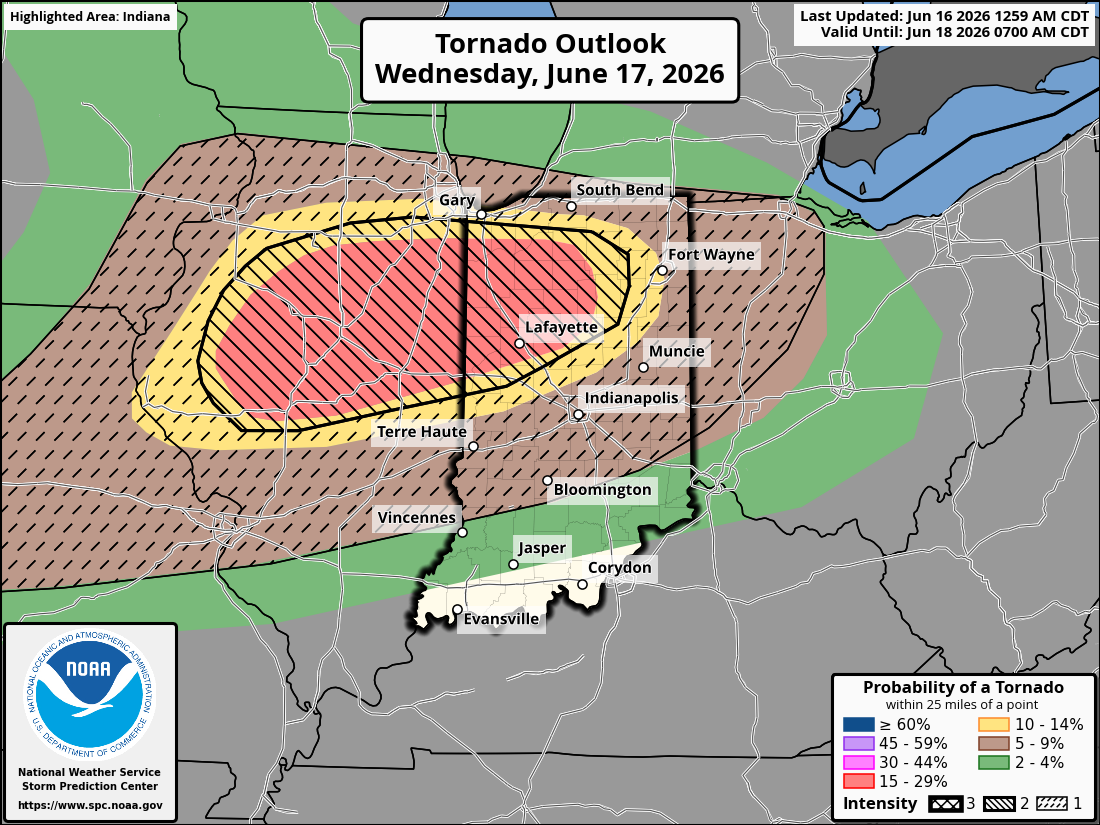
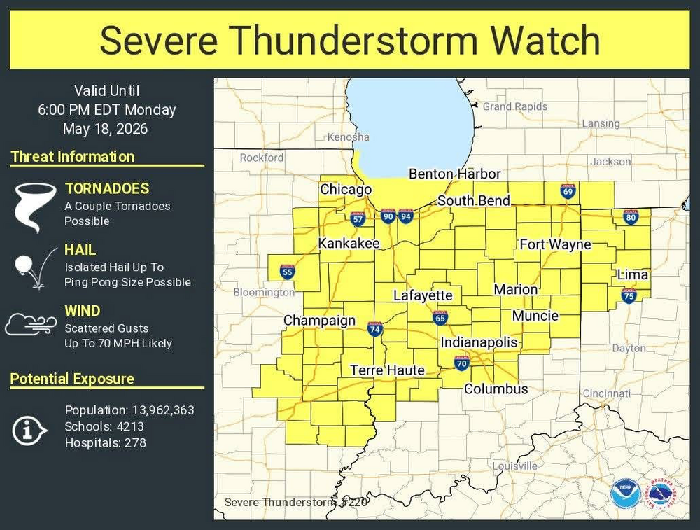
Tomorrow’s tornado probs… for posterity sake. 5% hatched imby, but 15% double hatched is just 30 minutes south.

-
An appetizer, if you will.
-
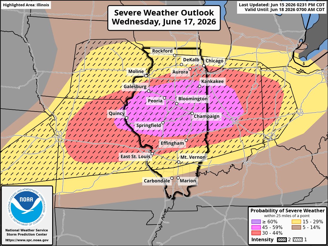
Also a large 45%

-
Zoomed in view
-
Sorry for the late post. I had to decompress after an exhausting two days at work covering the tornadoes and storm damage. It was another wildly memorable event for our area in an exceptionally busy Spring. I faired well in my backyard. Kept power and no damage. Obviously many nearby weren’t as lucky. We had so many amazing videos and photos to share at my tv station. It was like something out of the Great Plains. Looks like another round may be lurking next week.
-
Yesterday's line of storm was officially a derecho. Congrats to all who participated: NWS - Northern Indiana Good afternoon partners... Just as an FYI, we just received word from SPC that they confirmed yesterday's system was classified as a Derecho as it moved from Eastern Iowa through Lower Michigan. The wind swath had a track length over 400 miles, with a footprint just under 100,000 square miles. The strongest known gust was measured at 94 mph.
-
Gm bros
-
Storms crapped out just before they got this far east which was expected. Gusts to 40 mph. Big show will be tomorrow.
-
Getting excited for this one. I wish I didn't have to work because I'll be stuck in the newsroom/producer booth, but I'll be watching the storms on radar and through weather cameras. There are worse ways to make a living.
-
Hmmm... Meteorologist Ahmad Bajjey ordeonsSptl35ca7fc4lh6f7106413028f4t6g5u9a984m79fai3faif4l2m · This is going to be a bit of a read, but I want to draw your attention to something I've covered before. A little over a year ago, sweeping cuts to NOAA caused a large number of NWS locations to trim weather balloon launches either to 1 per day instead of the normal 2, or to remove launches completely. Upper-air data, the information collected by these, is the primary and overwhelming input factor into computer models. These go to everything from our forecasts, to NWS, to your app, to AI, etc. Model data fuels it all. Now, models are only as good as the data it ingests, and the more often or better the data, the more likely we can target a more accurate forecast. Notice I said more accurate, not perfect. We're not, but we do pretty darn well. Moving on. We started seeing data in models showing issues from a lack of input months ago, but I don't believe I've seen a NOAA office actually say it out loud until now. The Storm Prediction Center, the ones who are the best of the best when it comes to severe and destructive weather, creates all the daily severe weather outlooks, specifically stating they could not confirm an important part of the forecast because there was no measurement. No balloons over the Rockies or the plains this morning. Balloons launch at 0Z and 12Z each day, or they used to, and that lack of information not only affects the models but also the ability to create accurate forecasts. Kansas saw this exact issue to devastating effect this spring. We saw this issue when the northern MI ice storm showed horrible amounts of ice, and the amount was still more than any worst-case scenario model showed, as we lacked good input data from no launches in Green Bay and a single launch from Gaylord. Now, today, they all launched special 18Z balloons. Those happen on expected severe weather days. But these don't help morning or midday models, forecasts, or even aid in updating, as that is the usual window where storms may begin. Think of it like looking at a forecast, wherever that may be, and it saying to expect bad weather while it's already begun to hit. I say all of this because these are the facts. They're not pleasant, but the numbers don't lie; there is a measurable decline in model input and accuracy output. This affects every single forecaster, streamer, and app in the country. We all use the same info. And now a large agency has mentioned it directly. That's rather large weather news.
-
Best climo
-
Time to pay the pied piper after an incredible March and April. Snoozefest incoming.
-
HRRR and NAM bring 1-2” of rain to my backyard Sunday morning. Would be much appreciated if it happens.
-
Got nailed by a bowing segment at the workplace. Probably around 60 mph gusts. Power went out, generator has kicked in.
-
Seeing most reports between 55 mph and 65 mph as that line moves through NE IL/NW IN.
-
#ready2bgusted
-
And it’s gone. Realistic hope is to get some action as the boundary reignites just to my west in the early afternoon.
-
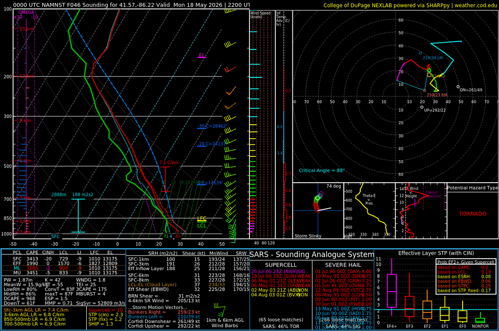
00z 3k NAM has a very impressive area of ingredients coming together in Northern Indiana and immediately surrounding areas for Monday afternoon. Nice sounding in South Bend. The HRRR much less impressive therefore I’m not showing it