

sbnwx85
-
Posts
1,316 -
Joined
-
Last visited
Content Type
Profiles
Blogs
Forums
American Weather
Media Demo
Store
Gallery
Everything posted by sbnwx85
-
Big crash on the Toll Road between South Bend and LaPorte. Snow hasn’t been super heavy but it’s enough. And it’s too cold for the road salt to work efficiently. Perfect recipe for crashes.
-

Winter 2024-25 Medium/Long Range Discussion
sbnwx85 replied to michsnowfreak's topic in Lakes/Ohio Valley
Dear sweet baby snow Jesus, I see what you have done for others and I pray you do this for me.
-
Woke up to about an inch of new snow. Thermometer says 3.
-
Not quite as bad as the 2024 White Sox season but it’s had its moments.
-
Winter 2024-25 Medium/Long Range Discussion
sbnwx85 replied to michsnowfreak's topic in Lakes/Ohio Valley
Starting to hold my breath. IWX is paying attention to it. Seems like more could go right than wrong for once this winter. “Somewhat greater concern for a more pronounced lake effect band setting up Wed night into Thursday with 925 mb streamlines and 850 mb omega fields all suggesting strong convergence down the long (major) axis of Lake MI as well as a connection to Lake Superior. These bands can be prolific snow producers and extend well inland. A lot of details to sort out in the coming days with final track of upper level and sfc features all key to the final alignment of the band. Also, unlike the current LES setup, the DGZ will climb to a more typical level and may reside near the top of or just above the best lift. Also, quality/depth of the moisture may be somewhat limited. Pops and potential snow amounts remain very conservative at this point, but something to monitor.” -
On the bright side I get to watch it snow all day without having to shovel.
-
Posted an update in the wrong thread earlier but the lake effect has at least produced continuous snowfall for about three hours now… although very little accumulation. Maybe an inch?
-
Winter 2024-25 Medium/Long Range Discussion
sbnwx85 replied to michsnowfreak's topic in Lakes/Ohio Valley
The low producing a nice snow storm to our south next week might also produce a decent lake response Wednesday night but I’m not going to hold my breath at this point. -
The lake effect portion of this sucks too. It’s barely sticking. About 0.5” from this system as a whole. It’s about this time of year I’m ready for Spring and storms.
-
Classic lake effect squall in LaPorte County slowly moving east. It should get here around 2:00 or 3:00. Otherwise sunny skies on either side of the squall. 2”-3” is my expectation once it gets here.
-
Solid DAB so far.
-
Thinking the defo band misses to my southeast. Lake effect should be decent tomorrow unless the wind tears apart the flakes. Current IWX forecast of 2”-4” looks solid.
-
Yea if nothing else the wind potential with this still looks impressive for everyone. Add 4”-10” between here, Fort Wayne and up to Detroit and it’ll be a fun storm.
-
12z updates your viewing pleasure or displeasure:
-
IWX mentioning potential ground blizzard conditions on Sunday especially in rural areas.
-
2.2” tonight. Snowpack up to 5”. Might be the highest it’s been all winter.
-
I think IWX goes with Winter Storm Watch(es?) overnight to cover the system and lake effect/wind. GRR may well do the same. Areas that don’t hit warning criteria from the system should get there thanks to the lake and the winds will be enough of an impact to justify it anyway. Both the HRRR and NAM have gusts over 30 knots on Sunday.
-
IWX only went with one to cover the potential ice impact. “If it was just snow, headlines would not likely be issued, but with the threat of freezing precip, it was decided to err on the side of caution and issue a Winter Weather Advisory from 4Z to 18Z Sat.”
-
Ripping here now. Might squeeze 2” out of this tonight.
-
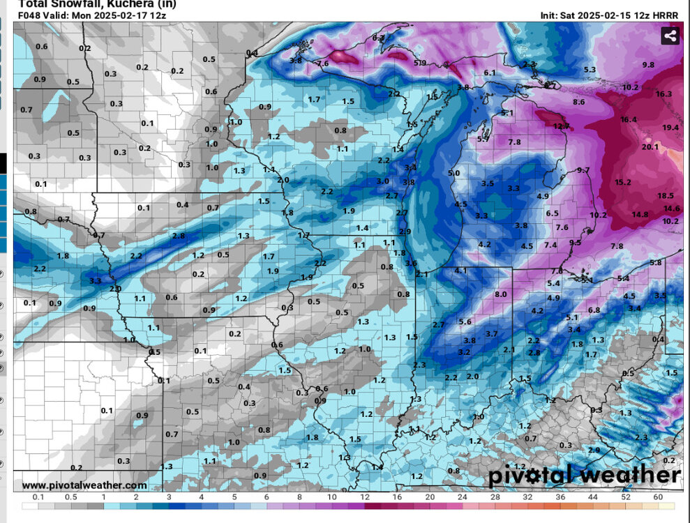
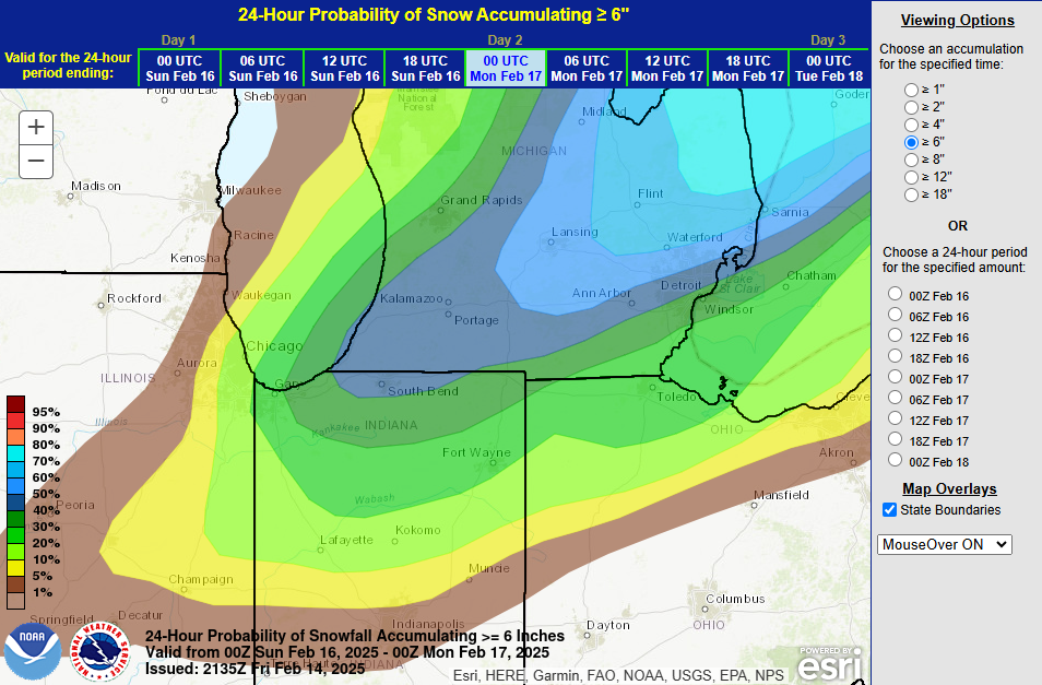
Might be slightly dated but I can get behind this. Edit: actually if I learned how to read I can see it was issued at 2135z today so not dated.
-
Hoping to get the goods from the system but truly am taking solace in the lake effect behind it. An inch tonight is a good bet. Then another 6" one way or the other Saturday night into Sunday.
-
I love seeing massive amounts of snow too, but there's nothing quite like a blizzard. Blinding heavy snow with roaring winds... ooo weee. It just hits different. It's a special and rare occurrence for most of us.
-
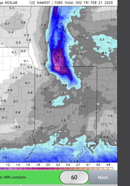
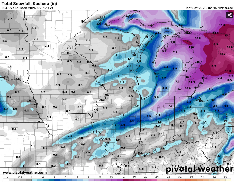
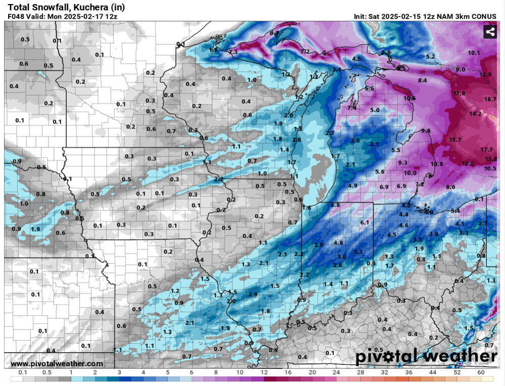
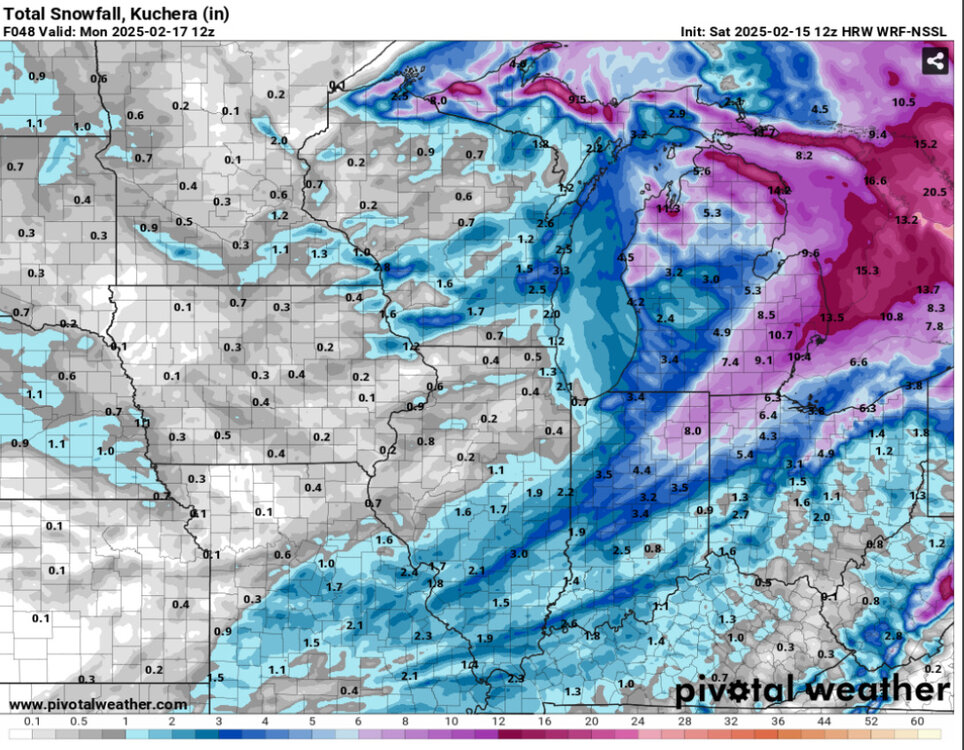
12k and 3k 18z NAM are still phenom for the northern third of Indiana, NW Ohio and epic for most of Michigan.
-
-
I know. I should know better than to doomcast. I got my hopes for a big dog from last storm and am still a little bitter.


