sbnwx85
-
Posts
1,317 -
Joined
-
Last visited
Content Type
Profiles
Blogs
Forums
American Weather
Media Demo
Store
Gallery
Everything posted by sbnwx85
-
Sign me up for this storm track in January.
-
Should be able to get to 25 straight days without any rain. Historic times we live in.
-
Honestly, if the weather is going to be boring and dry I'd rather have it during a month like September when it's normally boring.
-
Maybe some flurries. Just to get a taste. Save the rest for DJF.
-
Lake effect machine still works.
-

2024 Short/Medium Range Severe Weather Discussion
sbnwx85 replied to Chicago Storm's topic in Lakes/Ohio Valley
Very loud boomers around 4:30. Hearing some wind damage reports around town. Maybe round two later? -
You stole my thunder lol I had something typed up and was about to hit submit. All good!
- 231 replies
-
- 1
-

-
- absolute trainwreck?
- abandon all hope?
- (and 1 more)
-
The South Bend Airport hit 93.9 today. The HRRR and GFS have South Bend getting at or above 100 degrees tomorrow. South Bend has only seen triple-digit hit on 63 days in recorded history. The last time was July 6th, 2012 when the mercury hit 102. (4,434 days ago!) I'm not totally convinced we'll hit the century mark tomorrow... but it'll be worth watching!
- 231 replies
-
- 1
-

-
- absolute trainwreck?
- abandon all hope?
- (and 1 more)
-
Hit 90 here today too. Also an interesting tidbit from longtime South Bend meteorologist Bob Werner: We’ve had only 0.85", less than 20% of normal rain since July 17th. That has produced a rainfall deficit of more than 4" during that time. That's the 4th driest time we've ever recorded for those 39 days, and the driest since 1920! No significant chance of rain for at least several more days....
-
It's been nice not mowing the lawn so frequently.
-
We had some great house-shaking thunder this morning. Heavy rain but little wind. The frequent and nearby CG’s really made it a good storm though.
- 231 replies
-
- 2
-
-
- absolute trainwreck?
- abandon all hope?
- (and 1 more)
-
2024 Short/Medium Range Severe Weather Discussion
sbnwx85 replied to Chicago Storm's topic in Lakes/Ohio Valley
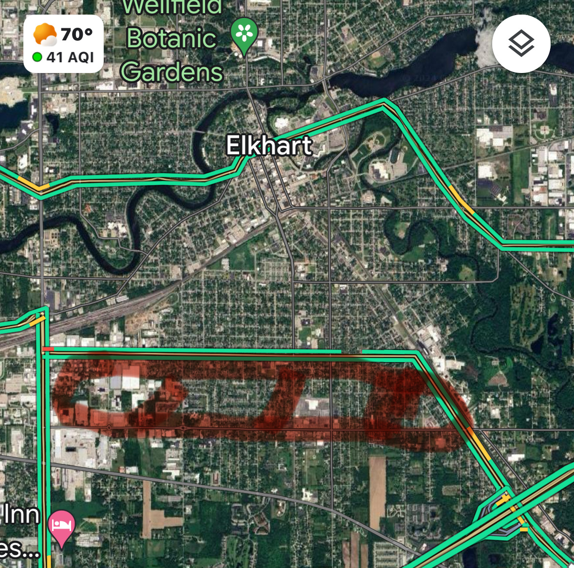
Confirmed tornado from earlier this week in Elkhart. Lots of trees toppled onto homes. No injuries or fatalities. This is only about a mile from where I grew up. Amazing to see virtually no damage outside of the tornado path... and tons of tree damage within this neigborhood. -
2024 Short/Medium Range Severe Weather Discussion
sbnwx85 replied to Chicago Storm's topic in Lakes/Ohio Valley
Even though the line was losing some of its punch we still managed 40-50 mph winds IMBY. Damage across the area was pretty typical for a summer time MCS. Although there is a pretty large swath in Elkhart, IN that probably got hit by a down burst and/or small tornado. Lots of tree damage.
-
2024 Short/Medium Range Severe Weather Discussion
sbnwx85 replied to Chicago Storm's topic in Lakes/Ohio Valley
Radar losing that look though. -
2024 Short/Medium Range Severe Weather Discussion
sbnwx85 replied to Chicago Storm's topic in Lakes/Ohio Valley
Tornado Warning in South Bend. Has that feel. -
2024 Short/Medium Range Severe Weather Discussion
sbnwx85 replied to Chicago Storm's topic in Lakes/Ohio Valley
CBS2 says likely tornado near OHare, one confirmed near Frankfort. Absolutely wild. Perhaps 10 tornadoes at the same time. Blanket warning was the right call. -
2024 Short/Medium Range Severe Weather Discussion
sbnwx85 replied to Chicago Storm's topic in Lakes/Ohio Valley
Getting lots of lightning from the warm front (?) swinging through ahead of the main line. -
2024 Short/Medium Range Severe Weather Discussion
sbnwx85 replied to Chicago Storm's topic in Lakes/Ohio Valley
They just said yall get TOR Warnings. -
2024 Short/Medium Range Severe Weather Discussion
sbnwx85 replied to Chicago Storm's topic in Lakes/Ohio Valley
Wa wa wee wa! -
2024 Short/Medium Range Severe Weather Discussion
sbnwx85 replied to Chicago Storm's topic in Lakes/Ohio Valley
Feeling better about tonight's potential out here. I'll plan to stay awake for it. -
2024 Short/Medium Range Severe Weather Discussion
sbnwx85 replied to Chicago Storm's topic in Lakes/Ohio Valley
I slept through most of last night’s storms. I woke up to some rumbles, looked at radar and the line was decaying. I guess I didn’t miss much. -
Added 0.90” of rain last night. 24-hour total at 2.67”.
-
2024 Short/Medium Range Severe Weather Discussion
sbnwx85 replied to Chicago Storm's topic in Lakes/Ohio Valley
Law enforcement reported funnel cloud in Elburn. Coming right into Geneva now. -
2024 Short/Medium Range Severe Weather Discussion
sbnwx85 replied to Chicago Storm's topic in Lakes/Ohio Valley
Hoping the line holds together enough to pack a decent punch this far east. It’ll be a close call. Should still get some thunder and heavy rain. -
2024 Short/Medium Range Severe Weather Discussion
sbnwx85 replied to Chicago Storm's topic in Lakes/Ohio Valley
The big one, two punch beginning soon. Mesoscale Discussion 1615 NWS Storm Prediction Center Norman OK 0315 PM CDT Sun Jul 14 2024 Areas affected...Parts of IA...northern IL...southern WI Concerning...Severe potential...Watch likely Valid 142015Z - 142145Z Probability of Watch Issuance...80 percent SUMMARY...Strong to severe storm development is expected later this afternoon into the evening. Eventual watch issuance is likely. DISCUSSION...Rather strong heating/destabilization is underway across much of IA this afternoon, while recovery in the wake of morning convection/outflow is ongoing across northern IL. Meanwhile, the remnant MCV from last night's severe MCS over the Dakotas is currently moving across northern IA. As MLCINH continues to erode across northern/eastern IA and MLCAPE increases above 3000 J/kg, the MCV may aid in scattered thunderstorm development later this afternoon. Midlevel flow is not particularly strong across the region, but sufficient to support effective shear of 25-35 kt and potential for some storm organization. Initial discrete development could evolve into a supercell or two, with a threat of hail, locally damaging wind, and possibly a tornado. In conjunction with the MCV, a persistent 20-30 kt southwesterly low-level jet could encourage relatively quick clustering and upscale growth, with some potential for an MCS to develop and move eastward across northern IL and southern WI this evening, with a continued severe-wind threat. Farther northwest, in the wake of the MCV, cumulus is deepening along a weak surface boundary across northwest IA. While this area is in the immediate wake of the MCV, strong buoyancy and sufficient deep-layer shear would support severe-thunderstorm potential in this area as well, if storms can mature. While favored timing and area remain somewhat uncertain, watch issuance will become increasingly likely if storm initiation appears imminent across the region. ..Dean/Hart.. 07/14/2024 ...Please see www.spc.noaa.gov for graphic product...