sbnwx85
-
Posts
1,358 -
Joined
-
Last visited
Content Type
Profiles
Blogs
Forums
American Weather
Media Demo
Store
Gallery
Everything posted by sbnwx85
-
You might squeeze a couple inches out this if it all goes right.
-
Snowing big wet flakes here. I miss the tornadoes.
-

4/2-4/3 Potential Major Severe WX Outbreak
sbnwx85 replied to Geoboy645's topic in Lakes/Ohio Valley
That's usually how it goes up here this time of year save 1920 and 1965. -
4/2-4/3 Potential Major Severe WX Outbreak
sbnwx85 replied to Geoboy645's topic in Lakes/Ohio Valley
Small town of Bourbon, IN took a hit from a likely tornado tonight. Several homes damaged. The high school is serving as a shelter. It's about 45 minutes south of South Bend. -
4/2-4/3 Potential Major Severe WX Outbreak
sbnwx85 replied to Geoboy645's topic in Lakes/Ohio Valley
Ope. Tornado Warning for Jasper County. Won’t take much tonight. -
4/2-4/3 Potential Major Severe WX Outbreak
sbnwx85 replied to Geoboy645's topic in Lakes/Ohio Valley
Mesoscale discussion is intriguing but the convection in Indiana right now looks like dog poopoo. -
4/2-4/3 Potential Major Severe WX Outbreak
sbnwx85 replied to Geoboy645's topic in Lakes/Ohio Valley
-
4/2-4/3 Potential Major Severe WX Outbreak
sbnwx85 replied to Geoboy645's topic in Lakes/Ohio Valley
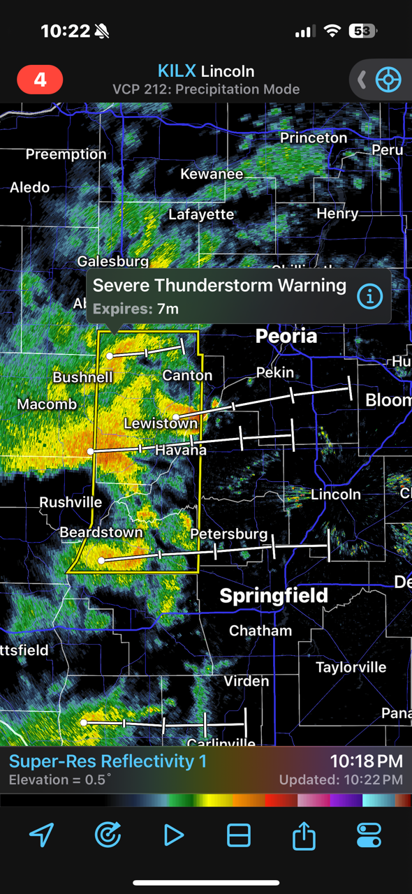
TOR Warned now. Radar indicated. -
4/2-4/3 Potential Major Severe WX Outbreak
sbnwx85 replied to Geoboy645's topic in Lakes/Ohio Valley
Enhanced pushed back north. We're so back. -
4/2-4/3 Potential Major Severe WX Outbreak
sbnwx85 replied to Geoboy645's topic in Lakes/Ohio Valley
HRRR making every effort to keep the dream alive here. -
4/2-4/3 Potential Major Severe WX Outbreak
sbnwx85 replied to Geoboy645's topic in Lakes/Ohio Valley
Looking like a nothing burger locally. South of a Fort Wayne to Lafayette line look like winners in Indiana. -
4/2-4/3 Potential Major Severe WX Outbreak
sbnwx85 replied to Geoboy645's topic in Lakes/Ohio Valley
Initiates storms a little further southwest giving my area a better chance at seeing some action. -
4/2-4/3 Potential Major Severe WX Outbreak
sbnwx85 replied to Geoboy645's topic in Lakes/Ohio Valley
It appears clearing should happen in the Michiana area, but still not totally convinced we'll get a big hit here based on convective initiation issues mentioned by Izzi seen on the HRRR. NAM would be a good hit, though. Just to my south and east looks better. -
4/2-4/3 Potential Major Severe WX Outbreak
sbnwx85 replied to Geoboy645's topic in Lakes/Ohio Valley
Yikes.
-
Snowflakes flying here.
-
4/2-4/3 Potential Major Severe WX Outbreak
sbnwx85 replied to Geoboy645's topic in Lakes/Ohio Valley
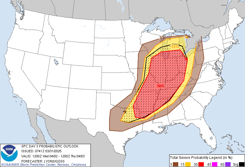
Large Day 3 Enhanced Risk. Fairly strong wording from SPC. Day 3 Convective Outlook NWS Storm Prediction Center Norman OK 0241 AM CDT Mon Mar 31 2025 Valid 021200Z - 031200Z ...THERE IS AN ENHANCED RISK OF SEVERE THUNDERSTORMS FROM THE LOWER GREAT LAKES THROUGH THE MID MISSISSIPPI VALLEY AND THE ARKLATEX... ...SUMMARY... An outbreak of severe storms is possible Wednesday and Wednesday night from the Lower Great Lakes, the Mid MS Valley and the ArkLaTex. Severe wind gusts, very large hail, and significant tornadoes are expected. ...Synopsis... A powerful, negative tilt, upper trough will move out of the Plains, over the Midwest and into the Great Lakes Wednesday. Accompanied by a 100+ kt jet streak, very strong forcing for ascent will overspread a large unstable warm sector from the Great Lakes, OH Valley and MS Valley. A strong cold front will sweep eastward with widespread to numerous thunderstorms expected. An outbreak of widespread severe storms including: significant tornadoes, severe wind gusts and very large hail is possible Wednesday and Wednesday night. ...Midwest to the lower Great Lakes and OH Valley... Early in the forecast period, one or more clusters of thunderstorms are likely to be ongoing across portions of KS/MO into the upper MS Valley. Very strong synoptic ascent at the exit region of the H5 jet may allow these storms to persist through the morning as the air mass downstream slowly destabilizes. Re-intensification is possible as storms move farther northeast into the lower Great Lakes by early to mid afternoon. Depending on the timing, these storms may also outrun the warm sector. This could limit the severe potential to points farther south if the airmass is unable to recover. Regardless, very strong effective shear (60-80 kt) and large hodographs would support organized storms capable of significant damaging winds, and a tornado risk. ...Mid MS Valley... Immediately southeast of the primary upper low track, more subtle forcing for ascent will overspread a rapidly moistening air mass across the Ozarks, eastern OK and the Mid MS Valley. The air mass will rapidly destabilize and become uncapped with MLCAPE of 1500-2500 J/kg likely by mid to late morning. Storms are likely to form by midday as ascent overspreads a pre-frontal trough/diffuse dryline. Some boundary parallel flow is likely suggesting a mixed mode of cellular and bowing segments. However, the very strong troposphereic shear profiles, courtesy of a 50+ kt low-level jet, favor significant supercells as the primary storm mode. A secondary surface low will serve to further back low-level flow and expand very large hodographs from the late afternoon into the evening hours. Very large hail, significant tornadoes and damaging winds all appear likely. The severe threat will continue overnight with some upscale growth across the Mid MS/TN Valley within the broadly unstable air mass. Consideration was given to higher severe probabilities across parts of the Mid MS Valley for the potential for multiple long-lived significant supercells. However, confidence in the exact storm mode and location of maximum threat remains unclear given some potential for morning convection and model timing variance.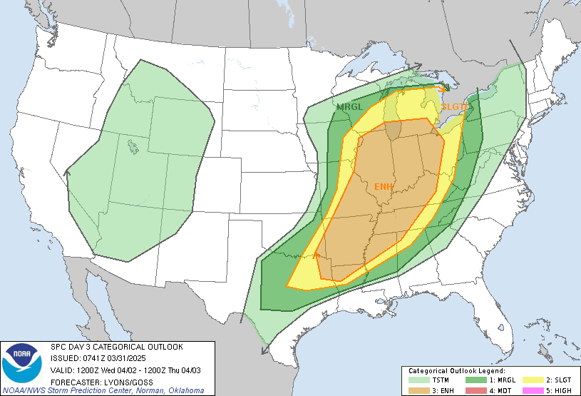
-
Top 5 storm for me. You could hear the wind and hail coming. Something I’ve never personally experienced. You hear about hearing a tornado coming… this was a wall of wind and pea-size hail. Winds maxed at about 60 mph. Power stayed but there are tree damage and power outage reports all over South Bend metro. I’ll upload a video to YouTube shortly.
-
I actually have a rare day off to enjoy severe weather. Usually I’m stuck in the newsroom. About 20 minutes from go-time. Severe Thunderstorm Warning upgraded to 70 mph winds and a tornado possible tag.
-
Day 3 enhanced and a large Day 6 slight risk. Times are good, friends.
-
Just had great CG and pea-sized hail come through. Great storm.
-
Looks stormy overnight. Hoping for some good rumbles.
-
Spring 2025 Medium/Long Range Discussion
sbnwx85 replied to Chicago Storm's topic in Lakes/Ohio Valley
I've seen a lot of social media posts already about the giant day 7 outlook. I agree that it seems premature to include such a large area at this point. The CSU forecast agrees with you, too.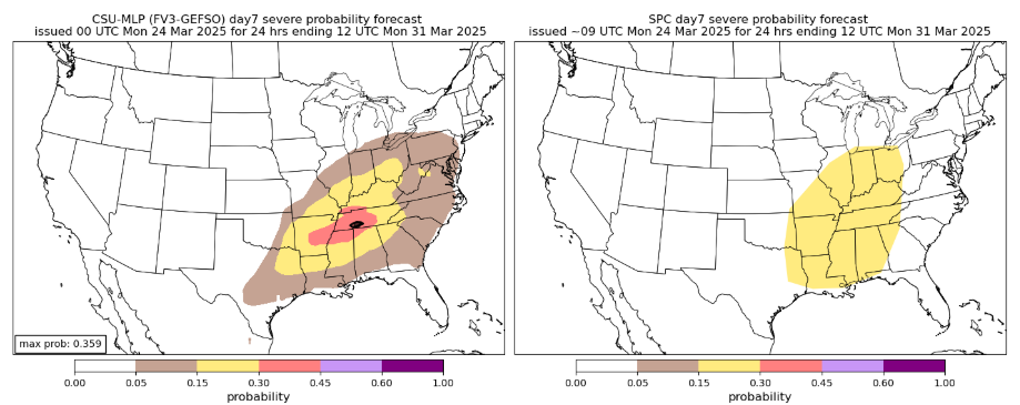
-
Severe Shower Warningz

-
Tornado confirmed in Fulton/Miami County, IN. Straight line winds in Cass County, IN Statement from the NWS: ...Preliminary Damage Survey Results of Damage from March 19, 2025 Severe Storms... Surveys have been completed from damage in 2 general locations, with initial details shared below. Additional details will follow this evening including any track maps as appropriate. .Logansport, IN (Cass County) NWS and EMA officials completed a survey of damage near and northeast of the Cass County Airport in Logansport, IN. Video footage of a funnel was received from EMA southwest of Logansport, but the damage found in the area was inconclusive regarding whether a tornado touched down and will thus be ruled as straight line winds. Additional details on maximum wind speeds and locations will come this evening. .Macy to south of Akron, IN (Miami into Fulton County) NWS and EMA officials completed a survey of damage of the above noted area and confirmed a tornado of EF0 intensity occurred, with maximum wind speeds of 80 to 85 mph. This started near Macy and ended south of Akron. Additional track and timing details will be released this evening. We would like to thank all emergency management, Indiana Department of Homeland Security, spotter and media for all the reports that were passed on.