sbnwx85
-
Posts
1,342 -
Joined
-
Last visited
1 Follower

About sbnwx85

- Birthday 10/04/1985
Recent Profile Visitors
6,169 profile views


-
Top 5 storm for me. You could hear the wind and hail coming. Something I’ve never personally experienced. You hear about hearing a tornado coming… this was a wall of wind and pea-size hail. Winds maxed at about 60 mph. Power stayed but there are tree damage and power outage reports all over South Bend metro. I’ll upload a video to YouTube shortly.
-
I actually have a rare day off to enjoy severe weather. Usually I’m stuck in the newsroom. About 20 minutes from go-time. Severe Thunderstorm Warning upgraded to 70 mph winds and a tornado possible tag.
-
Day 3 enhanced and a large Day 6 slight risk. Times are good, friends.
-
Just had great CG and pea-sized hail come through. Great storm.
-
Looks stormy overnight. Hoping for some good rumbles.
-

Spring 2025 Medium/Long Range Discussion
sbnwx85 replied to Chicago Storm's topic in Lakes/Ohio Valley
I've seen a lot of social media posts already about the giant day 7 outlook. I agree that it seems premature to include such a large area at this point. The CSU forecast agrees with you, too.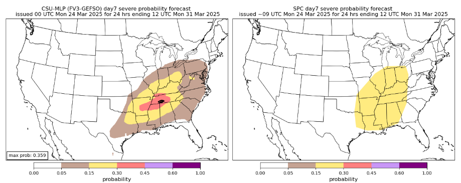
-
Severe Shower Warningz

-
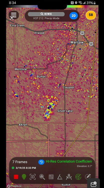
Tornado confirmed in Fulton/Miami County, IN. Straight line winds in Cass County, IN Statement from the NWS: ...Preliminary Damage Survey Results of Damage from March 19, 2025 Severe Storms... Surveys have been completed from damage in 2 general locations, with initial details shared below. Additional details will follow this evening including any track maps as appropriate. .Logansport, IN (Cass County) NWS and EMA officials completed a survey of damage near and northeast of the Cass County Airport in Logansport, IN. Video footage of a funnel was received from EMA southwest of Logansport, but the damage found in the area was inconclusive regarding whether a tornado touched down and will thus be ruled as straight line winds. Additional details on maximum wind speeds and locations will come this evening. .Macy to south of Akron, IN (Miami into Fulton County) NWS and EMA officials completed a survey of damage of the above noted area and confirmed a tornado of EF0 intensity occurred, with maximum wind speeds of 80 to 85 mph. This started near Macy and ended south of Akron. Additional track and timing details will be released this evening. We would like to thank all emergency management, Indiana Department of Homeland Security, spotter and media for all the reports that were passed on.
-
Reports of large trees down, house and barn damaged in the same area and time of this CC drop in Fulton and Kosciusko County, IN. No Tornado Warning.
-
Four Tornado Warnings in Indiana.

-
Gee, I wonder if it’s hailing?
-
I have to wonder if the dust being mixed in is helping make good lightning. Just a hypothesis.
-
2025 Short Range Severe Weather Discussion
sbnwx85 replied to Chicago Storm's topic in Lakes/Ohio Valley
I'd be excited for this one in LOT. Threat probably wanes pretty quickly this far east. -
March 14-15 Severe Weather Outbreak
sbnwx85 replied to HillsdaleMIWeather's topic in Lakes/Ohio Valley
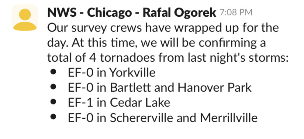
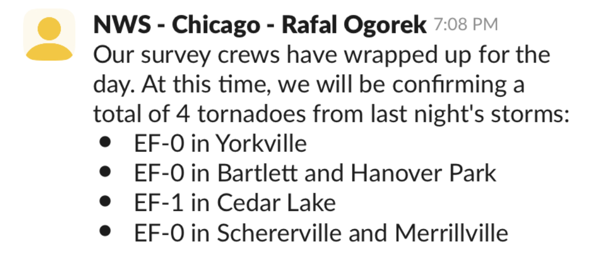
Four tornadoes surveyed in LOT.