Eskimo Joe
-
Posts
24,698 -
Joined
-
Last visited
Content Type
Profiles
Blogs
Forums
American Weather
Media Demo
Store
Gallery
Everything posted by Eskimo Joe
-

3/12 Event: Winters Last Hurrah at Least East of Mountains
Eskimo Joe replied to Weather Will's topic in Mid Atlantic
Snow is really cranking now. Easily the heaviest of the day and the winds are getting up there as well, just gusted to 21 mph on the home weather station. Temp down the 26°....amazing cold air advection for midday in March. -
3/12 Event: Winters Last Hurrah at Least East of Mountains
Eskimo Joe replied to Weather Will's topic in Mid Atlantic
Looks like Round #2 inbound. -
3/12 Event: Winters Last Hurrah at Least East of Mountains
Eskimo Joe replied to Weather Will's topic in Mid Atlantic
Down to 30 in Finksburg. @Mrs.Jmy wife is getting her first horse lesson in a snowstorm. -
3/12 Event: Winters Last Hurrah at Least East of Mountains
Eskimo Joe replied to Weather Will's topic in Mid Atlantic
Heard a big boom behind my.house and power pulsed. Trees starting to sag. Temp down to 31. -
3/12 Event: Winters Last Hurrah at Least East of Mountains
Eskimo Joe replied to Weather Will's topic in Mid Atlantic
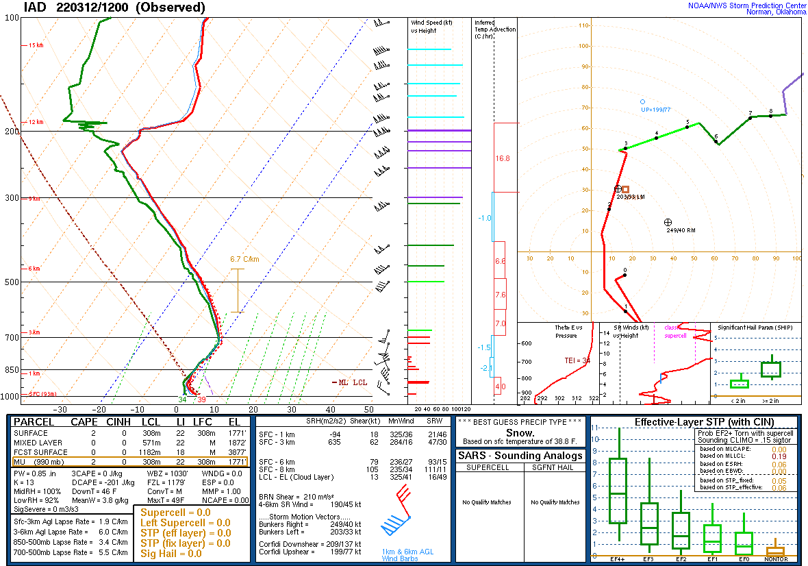
Delayed, but the 12z RAOB from IAD is a thing of beauty. No pesky warm layer, hence the "clean" transition.
-
3/12 Event: Winters Last Hurrah at Least East of Mountains
Eskimo Joe replied to Weather Will's topic in Mid Atlantic
-
3/12 Event: Winters Last Hurrah at Least East of Mountains
Eskimo Joe replied to Weather Will's topic in Mid Atlantic
I-70 starting to become a mess: -
3/12 Event: Winters Last Hurrah at Least East of Mountains
Eskimo Joe replied to Weather Will's topic in Mid Atlantic
DOT cams show even I-270 in Germantown is starting to cave. -
3/12 Event: Winters Last Hurrah at Least East of Mountains
Eskimo Joe replied to Weather Will's topic in Mid Atlantic
Now at 32° on the nose. Everything becoming snow covered. -
3/12 Event: Winters Last Hurrah at Least East of Mountains
Eskimo Joe replied to Weather Will's topic in Mid Atlantic
Looks like deep winter outside. 32.2° -
3/12 Event: Winters Last Hurrah at Least East of Mountains
Eskimo Joe replied to Weather Will's topic in Mid Atlantic
We went from rain to mix to sleet/snow in 20 min. -
3/12 Event: Winters Last Hurrah at Least East of Mountains
Eskimo Joe replied to Weather Will's topic in Mid Atlantic
Cul de sac and sidewalk caving. Temp now at 32°. 12z RAOB from IAD never posted on SPC -
3/12 Event: Winters Last Hurrah at Least East of Mountains
Eskimo Joe replied to Weather Will's topic in Mid Atlantic
Temp down to 32.5° -
3/12 Event: Winters Last Hurrah at Least East of Mountains
Eskimo Joe replied to Weather Will's topic in Mid Atlantic
Northern Baltimore and Harford added to the warning. -
3/12 Event: Winters Last Hurrah at Least East of Mountains
Eskimo Joe replied to Weather Will's topic in Mid Atlantic
I live by the PBS station in Reisterstown. All frozen. It's coming. -
3/12 Event: Winters Last Hurrah at Least East of Mountains
Eskimo Joe replied to Weather Will's topic in Mid Atlantic
Mulch and cars caving. -
3/12 Event: Winters Last Hurrah at Least East of Mountains
Eskimo Joe replied to Weather Will's topic in Mid Atlantic
Flipped to all sleet/snow. Temp down to 35 degrees. What a transition! -
3/12 Event: Winters Last Hurrah at Least East of Mountains
Eskimo Joe replied to Weather Will's topic in Mid Atlantic
Mixing with sleet in Reisterstown. Temp down 10 degrees in an hour to 36°. -
3/12 Event: Winters Last Hurrah at Least East of Mountains
Eskimo Joe replied to Weather Will's topic in Mid Atlantic
@psuhoffman speaking about this now in the zoom call. ICON (SUCKS) but better along I-95 and west. -
3/12 Event: Winters Last Hurrah at Least East of Mountains
Eskimo Joe replied to Weather Will's topic in Mid Atlantic
They were upgraded by CTP this afternoon. -
3/12 Event: Winters Last Hurrah at Least East of Mountains
Eskimo Joe replied to Weather Will's topic in Mid Atlantic
The last time the Blue Ridge (and DC/Baltimore for that matter) was under a Blizzard Warning was 6 years ago. -
3/12 Event: Winters Last Hurrah at Least East of Mountains
Eskimo Joe replied to Weather Will's topic in Mid Atlantic
SPC meso analysis starting to pick up on the good frontogenetic forcing developing over the TN River Valley. There are reports from some mets on Twitter that rates are upwards of 1" - 1.5" under the band in SW TN. A good sign. -
3/12 Event: Winters Last Hurrah at Least East of Mountains
Eskimo Joe replied to Weather Will's topic in Mid Atlantic
He's out west skiing. -
3/12 Event: Winters Last Hurrah at Least East of Mountains
Eskimo Joe replied to Weather Will's topic in Mid Atlantic
I don't blame LWX at all for holding with advisories. Too many last minute things can go wrong...always easier to up the ante. 12z RAOB from IAD, RNK, and PBZ will be telling tomorrow am. -
3/12 Event: Winters Last Hurrah at Least East of Mountains
Eskimo Joe replied to Weather Will's topic in Mid Atlantic
00z NAM appears to remove and potential warm layer at 800mb. Would promote a "clean" transition from rain to snow.