

Eskimo Joe
-
Posts
24,640 -
Joined
-
Last visited
Content Type
Profiles
Blogs
Forums
American Weather
Media Demo
Store
Gallery
Everything posted by Eskimo Joe
-

2022 Mid-Atlantic Severe Wx Thread (General Discussion Etc)
Eskimo Joe replied to Kmlwx's topic in Mid Atlantic
Decent mamatus in Reisterstown from that DC cell. -
2022 Mid-Atlantic Severe Wx Thread (General Discussion Etc)
Eskimo Joe replied to Kmlwx's topic in Mid Atlantic
The one good thing we still have going for us is that we have a decent bit of shear and low level lapse rates. My temp has rebounded to 75 degrees so it's possible we could see a few beefy cells, but yea this morning's activity really capped any potential for a high end event in these parts. -
2022 Mid-Atlantic Severe Wx Thread (General Discussion Etc)
Eskimo Joe replied to Kmlwx's topic in Mid Atlantic
zzzz...next -
2022 Mid-Atlantic Severe Wx Thread (General Discussion Etc)
Eskimo Joe replied to Kmlwx's topic in Mid Atlantic
That crapvection entering DC and Baltimore metro might be the kiss of death for this afternoon if we don't get some respectable sunshine behind it. -
2022 Mid-Atlantic Severe Wx Thread (General Discussion Etc)
Eskimo Joe replied to Kmlwx's topic in Mid Atlantic
Saturday is the day for our western folks -
2022 Mid-Atlantic Severe Wx Thread (General Discussion Etc)
Eskimo Joe replied to Kmlwx's topic in Mid Atlantic
-
2022 Mid-Atlantic Severe Wx Thread (General Discussion Etc)
Eskimo Joe replied to Kmlwx's topic in Mid Atlantic
Naw the SWODY MOD is our curse. Going to wait until midday tomorrow before I decide where I'm in or out. -
2022 Mid-Atlantic Severe Wx Thread (General Discussion Etc)
Eskimo Joe replied to Kmlwx's topic in Mid Atlantic
Yea. I'm with you. Expect to be underwhelmed and you won't be disappointed in these parts. -
2022 Mid-Atlantic Severe Wx Thread (General Discussion Etc)
Eskimo Joe replied to Kmlwx's topic in Mid Atlantic
Stop living and dying by sim reflectivity. -
2022 Mid-Atlantic Severe Wx Thread (General Discussion Etc)
Eskimo Joe replied to Kmlwx's topic in Mid Atlantic
If we manage good sun tomorrow, I could see a low end MOD Risk for wind. The potential is definitely there. -
2022 Mid-Atlantic Severe Wx Thread (General Discussion Etc)
Eskimo Joe replied to Kmlwx's topic in Mid Atlantic

-
Summer max contest -- final results posted
Eskimo Joe replied to Roger Smith's topic in Mid Atlantic
DCA: 99IAD: 100BWI: 101RIC: 100 -
I'll be fishing Rocky Gap State Park next Friday, Saturday, and Sunday. Hoping it's warm and gets the fish into the shallows.
-
2022 Mid-Atlantic Garden, Lawn, and Other Green Stuff Thread
Eskimo Joe replied to mattie g's topic in Mid Atlantic
@GramaxRefugee our fig tree is leafing out too! We opted for a Chicago Black, what kind is yours? -
2022 Mid-Atlantic Severe Wx Thread (General Discussion Etc)
Eskimo Joe replied to Kmlwx's topic in Mid Atlantic
Y'all: -
2022 Mid-Atlantic Severe Wx Thread (General Discussion Etc)
Eskimo Joe replied to Kmlwx's topic in Mid Atlantic
The PDS Blue Box in the midwest is insane. 2012 Derecho on steroids. For @yoda yea that's the only thing I can think of...storms bubbling up along the edge of a high...IIRC the 2012 Derecho was an impulse riding the edge of a pretty big high pressure system and since it wasn't an airmass change it kept temps from cooling off post event. -
2022 Mid-Atlantic Severe Wx Thread (General Discussion Etc)
Eskimo Joe replied to Kmlwx's topic in Mid Atlantic
Looks like a broken SW -> NE line of reports trickling in from the Stuarts Draft tornado warning. Definitely possible something went through there. -
2022 Mid-Atlantic Severe Wx Thread (General Discussion Etc)
Eskimo Joe replied to Kmlwx's topic in Mid Atlantic
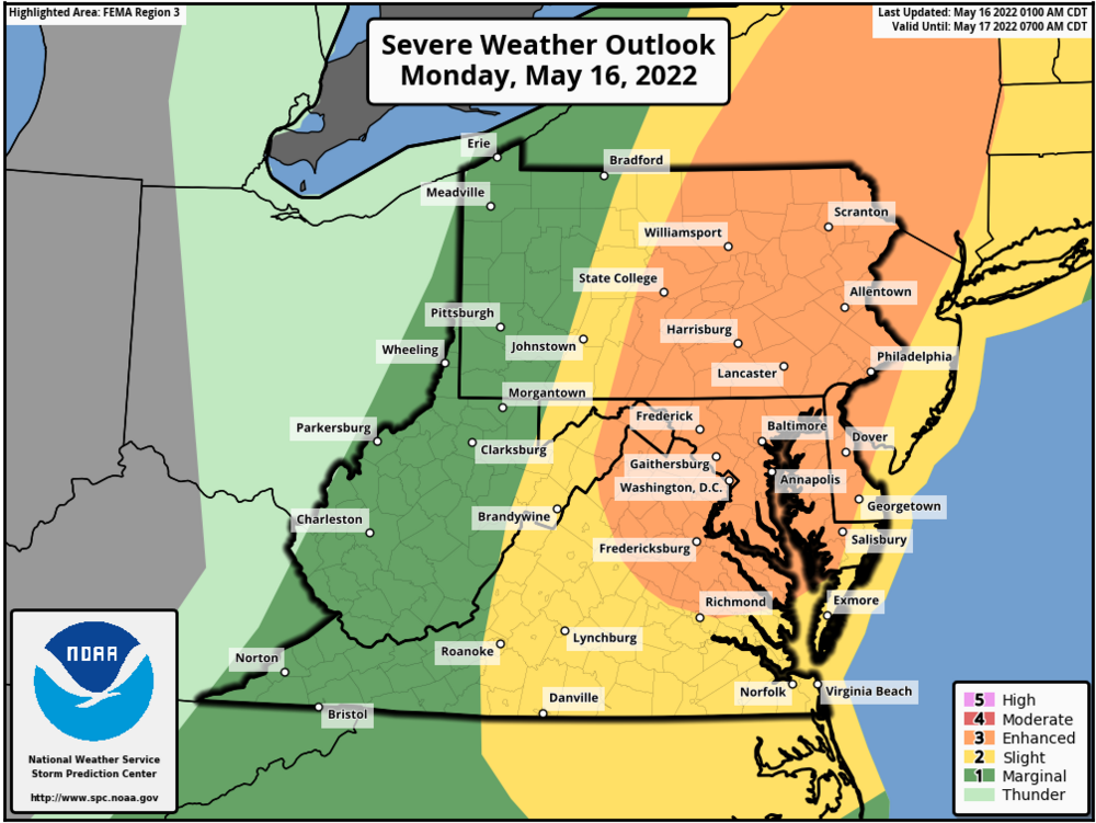
Oooo...spicy. Maybe something went through here? -
2022 Mid-Atlantic Severe Wx Thread (General Discussion Etc)
Eskimo Joe replied to Kmlwx's topic in Mid Atlantic
That cluster of tornado warned storms might make a run at far southern Maryland tonight. Even if they lose their tornadic potential, they would probably bring some gully washers. -
Yes. You can see the line segment starting to develop out west towards Cumberland. Even some lightning with it.
-
HRRR throws a decent number of discrete cells and even a few UHI tracks near RIC this afternoon. Couple of beefy looking line segments event up through the NW suburbs of DC.
-
Woodbine doesn't flood too much. Sams Creek Rd @ Oak Orchard Rd towards New Windsor is more of an issue. Skyesville has issues in the historic district.
-
Oh look, more clouds.
-
Stupid cold nights have set the bass ponds back. Tons of nests but everything went deep again.


.gif.c62bab3b3771688c604a8a5cb8002d23.gif)
