

Eskimo Joe
-
Posts
21,918 -
Joined
-
Last visited
Content Type
Profiles
Blogs
Forums
American Weather
Media Demo
Store
Gallery
Everything posted by Eskimo Joe
-
Hell, if we manage like back-to-back-to-back 5" - 10" event in the course of like 2 weeks that would be 100%+ of climo for everyone.
-
I'm not expecting consistent double digit snowfalls, but this should at least get almost everyone to climo if the pattern holds. Hell, after the past two winters climo will feel great.
-
The signal from mid January on is hawt. I haven't been this excited since 2010.
-
Yea the evolution really is nice.
-
^there's definitely been a trend to nudge everything over to NA instead of the other side of the hemisphere. Good to see.
-
Yup. Less latent heat release and more time to accrete in cold surfaces.
-
-
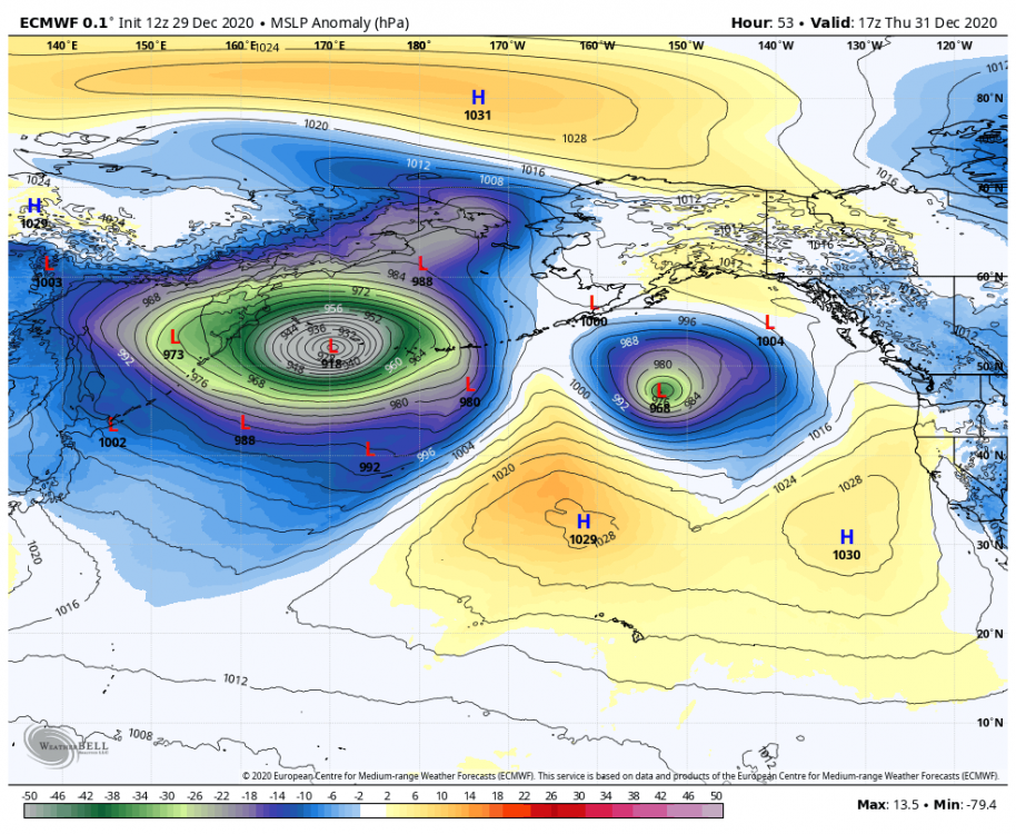
It's a damn shame we can rid ourselves of this low in the Gulf of Alaska. Without it, that Aleutian Low would be pumping one hell of a west coast ridge for us.
-
Key difference with Euro weeklies now is that it's NW flow across all of Canada which rapidly builds snow cover and solidifies a cP airmass for us. If this holds, it significantly increases the likelihood of below normal temps and at least embedded clippers.
-

Central PA - Winter 2020/2021
Eskimo Joe replied to MAG5035's topic in Upstate New York/Pennsylvania
Self quarantined for 2 weeks and a negative COVID test allowed us to see the in laws in Mt. Joy. We were rewarded with a dusting of snow last night. -
Nothing in Reisterstown.
-
How nice of WPC to use Christmas colors. This makes the 50 and rain worth it.
- 485 replies
-
- 12
-

-

-
N. Georgia and E. Tennessee get.more snow than DC on the HRRR. This is absolutely believable and shows how bad our snow climo is.
-
Meso's trying to hit the back end snow more HRRR has some little max near St. Mary's and Calvert counties, unless I'm missing something.
-
-
-
You need to move somewhere else. You know the climo of this area and yet you still go berserk every year that isn't a 2009 - 2010.
-
-
Isn't there a correlation of Mongolian highs and cold/wet conditions on the eastern CONUS?
-
2020 Mid-Atlantic Severe Weather - General Thread
Eskimo Joe replied to Kmlwx's topic in Mid Atlantic
Over/under on a surprise watch box? I'm going 40%. -
I'm always conservative with mixed bag events and any snow map beyond D2.
-
Central PA - Winter 2020/2021
Eskimo Joe replied to MAG5035's topic in Upstate New York/Pennsylvania
18z GFS/GEFS showing some Christmas love for all of CTPs CWA. Solid advisory level event. -
1" - 3" for everyone on Christmas Eve / early Christmas morning is money.
-
The updated NWS radar is terrible
Eskimo Joe replied to Heisy's topic in Weather Forecasting and Discussion
This interface is very slow and seems to rely on third party data for the underlying base map. Given the antecedent challenges with NWS IT infrastructure their move to this product was, IMO, short sighted. I prefer the old radar because it was faster to load, easier to interpret, and still worked when you had limited data connection. I encourage anyone with a strong opinion, positive or negative, to email: [email protected] -
19 for a low in Reisterstown. Coldest in 4 years.


