

Eskimo Joe
-
Posts
24,731 -
Joined
-
Last visited
Content Type
Profiles
Blogs
Forums
American Weather
Media Demo
Store
Gallery
Everything posted by Eskimo Joe
-
This is a winter board. We tolerate 10 months to live for 2. Every year, we see winter slip away slowly. Then, when things get close, folks get jumpy if it looks the every diminishing window for snow looks to be a dud. It's an annual ritual.
-

4 New METAR Sites Now Available
Eskimo Joe replied to vortex95's topic in Weather Forecasting and Discussion
KDNN appears to be an AWOS III. Airport seems rather tiny for 40k ceilometer. -
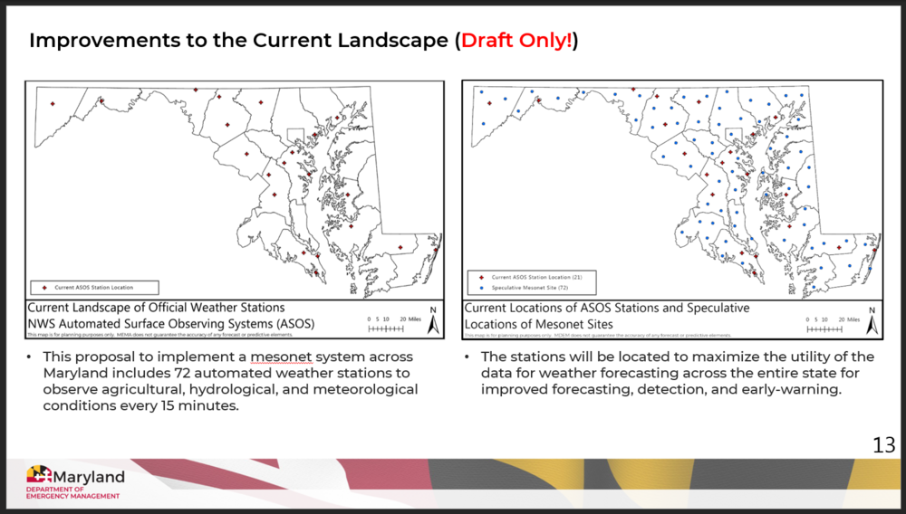
I can share this. A slide from some of our internal data and preliminary research . This information is subject to change:
-
We're aware of significant data gaps in northern Baltimore, Harford, Howard, Charles, and Kent counties. The Baltimore County gap is especially problematic for the I-83 corridor in the winter as I'm sure you're aware.
-
We have secured funding for at least 70 sites. I can't speak too much yet to the nitty gritty on site placement, but we have some UMD staff that are running simulations on where to best place sites relative to census data (population density, societal risk), and existing infrastructure (AWOS, ASOS, USGS stream gauges, etc.).
-
Yup. This is a BFD for Maryland. Expect //a lot// of good things from this. We spoke with numerous existing mesonets, the private sector, academia, NWS, and local/state EMs, DOTs, and farmers to make sure this program gets a solid foundation under it.
-
I'd take that in a heartbeat.
-
10/10 autumn day
-
Well, at least we didn't get October snow this year. Always seems to be a death kiss for winter.
-

-
Thick frost on the fig tree this morning. It's toast. Down to 33, no freeze yet.
-
Thick frost in Reisterstown this morning. Low of 33.
-
From your mouth to the snow gods ears.
-
Mind if I ask why your station has been dropping so much recently?
-
Looks like good swimming weather
-
If we can clear out and decouple tonight, we could really see an early-ish freeze even into I=95. Airmass is cold and dry.
-
Just got expanded.
-
39 in Reisterstown
-
Prior to this game, Ravens only were behind 11:30 total time all year. Just bad timing.
-
Not a drop in Reisterstown. Had storms to the NW of me last nice and precip shield to my SE.
-
Drive by Liberty or Prettyboy reservoirs, color is really ramping up.
-
Yea, but did they roll uphill both ways to the school?


