

Eskimo Joe
-
Posts
24,701 -
Joined
-
Last visited
Content Type
Profiles
Blogs
Forums
American Weather
Media Demo
Store
Gallery
Everything posted by Eskimo Joe
-

Central PA Winter 2022/2023
Eskimo Joe replied to Blizzard of 93's topic in Upstate New York/Pennsylvania
Friendly reminder to not doom and gloom over individual runs of operational models beyond D5. Put more weight in ensembles. -
Was referring to December snow climo. Obviously December 2009 is the gold standard, but just cover the grass for Christmas please. Looks like cross polar flow and a solid PNA ridge. Very good to see.
-
Snow climo down here is not as robust as Philly (grew up in Roxborough/Manayunk). If we manage a 4" - 8" storm out of this for Christmas proper, it will exceed norms for IAD, BWI, DCA. That's a win in my book.
-
Still a decent number of storm related calls for icing in northern & western Frederick County, MD.
-
Central PA Winter 2022/2023
Eskimo Joe replied to Blizzard of 93's topic in Upstate New York/Pennsylvania
12z EPS is a classic look for an east coast storm. This gets everybody on the board and probably meets or exceeds December climo for many. -
12z EPS has great banana high from Texas to Quebec. Classic east coast storm signal.
-
You mean this one? http://www.raymondcmartinjr.com/weather/2001/30-Dec-00.html
-
All aboard the Eskimo Express!
-
Agreed. Classic vort pass for a solid plowable snowfall at IAD, DCA, and BWI.
-
-
Not surprising this came on quick. HM has said in the past that PNA and EPO forecasting beyond D7 isn't as reliable as the AO/NAO.
-
IMO, the 2hr delay calls were good. It allowed people to just pace themselves.
-
Up in Westminster for an appointment and it'd 32 with ZR on the sidewalks by the airport.
-
M0.05 ZR Reisterstown
-
Central PA Winter 2022/2023
Eskimo Joe replied to Blizzard of 93's topic in Upstate New York/Pennsylvania
From the Mid Altantic forum. This bodes even better for folks in this subforum. -
Alert MCPS MCPS, including the Virtual Academy, will open two hours late Thursday, Dec. 15, due to anticipated emergency weather conditions. More information at www.montgomeryschoolsmd.org
-
No, The Eskimo Express.
-
Down to 31/19 in Reisterstown
-

-
This is classic @psuhoffman how we win. As @WxUSAF said, 3" - 6" in December is climo and then some.
-
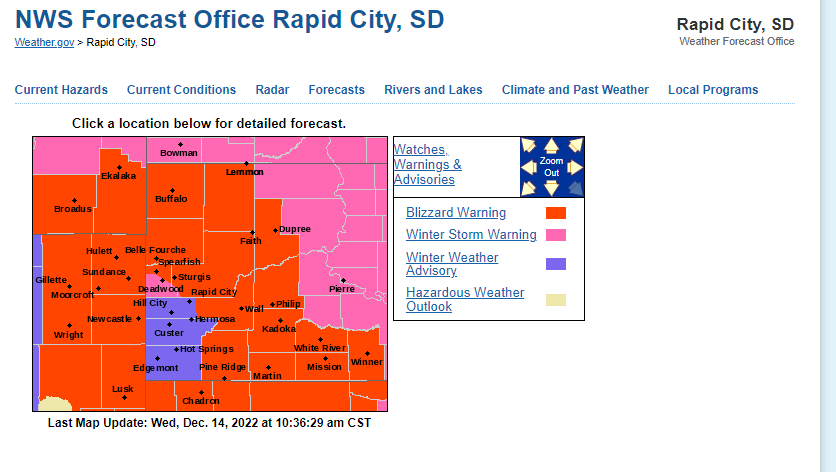
Take a look at the hole in blizzard conditions in SW South Dakota. Imagine if that occurred here. Ji would have the meltdown to crash the board.
-
Ice map seems reasonable. Last updated 9:44 am this morning.
-
@MillvilleWx excellent write up as always. Your thoughts mirror mine as well. My only two questions are: 1.) Does cloud cover minimize our high temps and we bust low. 2.) With this starting overnight, does the lack of insolation mean ice accretes more effectively?
-
Looks like LWX extending the WWA for the Mason-Dixon counties until 4pm tomorrow. Makes sense, dews seem a bit lower than forecast, it's cloudy today and surfaces are chilled.
-
Icing is inherently tricky for forecast. This link was posted a few pages ago, but am posting again. Would encourage members to book mark this: https://training.weather.gov/wdtd/courses/woc/winter/fcst-hzds/ice-storm-accum/presentation_html5.html It's only 20 - 25 min and well worth your time.


