

Eskimo Joe
-
Posts
21,922 -
Joined
-
Last visited
Content Type
Profiles
Blogs
Forums
American Weather
Media Demo
Store
Gallery
Everything posted by Eskimo Joe
-
IAD at 95 and FDK at 97. Probably pre-frontal winds and touch of downsloping aiding in the spike.
-
Would argue that given the meso disco out, even though it's only 40% watch probability, that we get upgraded to a slight risk with the afternoon update.
-

2021 Mid-Atlantic Severe Weather - General Discussion
Eskimo Joe replied to Kmlwx's topic in Mid Atlantic
Something to add to your knowledge base: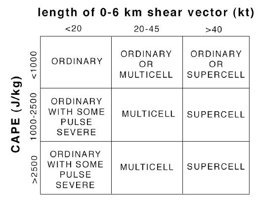
-
I ran a history of all Excessive Heat Advisories through the iembot. I don't have the time to view the results, but here's a KML file you can pop into Google maps/earth to see what the density is: sbw_interval.kml
-
06z GFS is a weak system into the SE US.
-
2021 Mid-Atlantic Severe Weather - General Discussion
Eskimo Joe replied to Kmlwx's topic in Mid Atlantic
Tomorrow could be sneaky good. We've been baking for 2 days and there's an actual front pressing down. -
2021 Mid-Atlantic Severe Weather - General Discussion
Eskimo Joe replied to Kmlwx's topic in Mid Atlantic
No kicker, we lose. -
102 at DMW at 5:30 pm...wow. FWIW, it's 99 at New Windsor 6 miles down the road in the shade so I think that's a legit reading.
-
IAD hits new record high of 100.
-
CBE hit 99...FDK, HGR, and DMW hit 100 today. Really over performing heat today!
-
95/73/106 in Gaithersburg
-
2021 Mid-Atlantic Garden, Lawn, and Other Green Stuff Thread
Eskimo Joe replied to mattie g's topic in Mid Atlantic
46 tomatoes and 3 zucchini harvested yesterday. What a haul this year after a slow start in the garden. -
They're already in NE Maryland.
-
2021 Mid-Atlantic Severe Weather - General Discussion
Eskimo Joe replied to Kmlwx's topic in Mid Atlantic
37 storm related calls in just the Bethesda area. 56 total across down county. -
2021 Mid-Atlantic Severe Weather - General Discussion
Eskimo Joe replied to Kmlwx's topic in Mid Atlantic
60% chance of a WW this afternoon. -
2021 Mid-Atlantic Severe Weather - General Discussion
Eskimo Joe replied to Kmlwx's topic in Mid Atlantic
There we go: -
2021 Mid-Atlantic Severe Weather - General Discussion
Eskimo Joe replied to Kmlwx's topic in Mid Atlantic
Given the amount of DCAPE and strong sunshine today, I'm surprise we aren't in a DY1 slight risk. There's another kicker working through the region this afternoon and it might yield similar results to yesterday. -
2021 Atlantic Hurricane Season Tracking Thread
Eskimo Joe replied to WxWatcher007's topic in Mid Atlantic
He says a lot of things. -
2021 Mid-Atlantic Severe Weather - General Discussion
Eskimo Joe replied to Kmlwx's topic in Mid Atlantic
If there's good DCAPE and a kicker we seem to jackpot here. It almost can compensate for the lack of shear and mid level lapse rates. -
2021 Atlantic Hurricane Season Tracking Thread
Eskimo Joe replied to WxWatcher007's topic in Mid Atlantic
I think we can stick a fork in TD six...between the mountains and that upper level low in Florida, it looks like a turd. -
FWIW, it appears that Raven Rock aka Site R now has an ASOS. Station ID: KXIF
-
ASCAT data, though showing a sharp cutoff and increasing organization, doesn't show much in the way TS-force wind barbs over a significant area. There isn't much of a threat of storm force impacts at moment of genesis unless the winds increase here. They are likely just being patient as they have more liberty/luxury to do so versus say a situation like Elsa earlier this season that immediately had TS force upon genesis. That being said, we may still yet see PTC advisories go up by 5 AST. Good copy, thanks.
-
Western Maryland (Garrett, Allegheny, Washington counties) don't fare as well as other places with your classic Miller A nor'easter. IMO, if you are looking for a good spot to get a nor'easter, check out the Catoctin Mts. in Frederick County. Some places to look to are: Braddock Heights, Myersville, Wolksville, Sabillasville, Catoctin Furnace. You can easily get a cheap piece of property above 1,000 to 1,200 feet and there's a lot to do nearby outside of snow season.
-
Perhaps a met could answer this question, but why hasn't this been designated as a Potential Tropical Cyclone yet? I've seen worse things than this get that designation.
-
600dm or bust


