Eskimo Joe
-
Posts
24,735 -
Joined
-
Last visited
Content Type
Profiles
Blogs
Forums
American Weather
Media Demo
Store
Gallery
Everything posted by Eskimo Joe
-
Looks like I was overly pessimistic. Clearing out nicely in Maryland...our Frostburg mesonet site should get some nice solar data. www.mesonet.umd.edu
-

April 8th Eclipse- Last Easy One To See In My Lifetime
Eskimo Joe replied to Interstate's topic in Mid Atlantic
It's really not looking good for DC and west it seems. That's a lot of low level junk streaming out of West Virginia. -
April 8th Eclipse- Last Easy One To See In My Lifetime
Eskimo Joe replied to Interstate's topic in Mid Atlantic
Try Plattsburgh? -
Sub 1000 mb lows racing northeast from Ohio into NW Pennsylvania don't go quietly in the night. We could definitely see the first legit slight risk of the year Thursday.
- 1,696 replies
-
- 3
-

-
- severe
- thunderstorms
- (and 5 more)
-
The Pirates are 8-2. Do I dare have hope this year?
-
2024 Atlantic Hurricane Season
Eskimo Joe replied to Stormchaserchuck1's topic in Tropical Headquarters
Aren't La Nina summers historically a higher risk for landfall along the east coast of the United States? -
April 8th Eclipse- Last Easy One To See In My Lifetime
Eskimo Joe replied to Interstate's topic in Mid Atlantic
Big astronomy is up to something. -
Working on the first site at Robert Moton elementary in Westminster.
-
April 8th Eclipse- Last Easy One To See In My Lifetime
Eskimo Joe replied to Interstate's topic in Mid Atlantic
Apologies for the spelling error. I was saying you should just go to Maine. -
April 8th Eclipse- Last Easy One To See In My Lifetime
Eskimo Joe replied to Interstate's topic in Mid Atlantic
Just go to Maine. Edit: spelling -
I wonder if a +PNA would have prevented the earthquake. /s
-
2024 Mid-Atlantic Garden, Lawn, and Other Green Stuff Thread
Eskimo Joe replied to mattie g's topic in Mid Atlantic
Thank you! Thank you! -
Almost like a CCB on radar from central Baltimore County and points NE. If this were winter they'd be smoked with cold powder.
-
2024 Mid-Atlantic Garden, Lawn, and Other Green Stuff Thread
Eskimo Joe replied to mattie g's topic in Mid Atlantic
I'm looking for a batch of native flowering seeds that I can scatter over a 100 x 100 ft area. It's slightly moist, with intermittent sun. Looking to just throw them and see what grows. Any suggestions? -
More rain coming for DC? lol
-
Looks like the tornado watch will verify unfortunately. Several reports out of the Richmond area of homes damaged.
-
I think the cool, stable surface airmass is mitigating the downward transport of wind. That line has passed over 2 mesonet sites, College Park and Baltimore City, and has not produced a wind gust greater than 10 mph.
-
TVS just NW of RIC on AKQ radar. Storm is currently unwarned.....
-
Storm near Lake Anna, VA is realllly trying.
-
Some discrete stuff popping NW of Richmond. The storm near Louisa, VA is my money.
-
First tornado watch for our Delmarva mesonet stations.
-
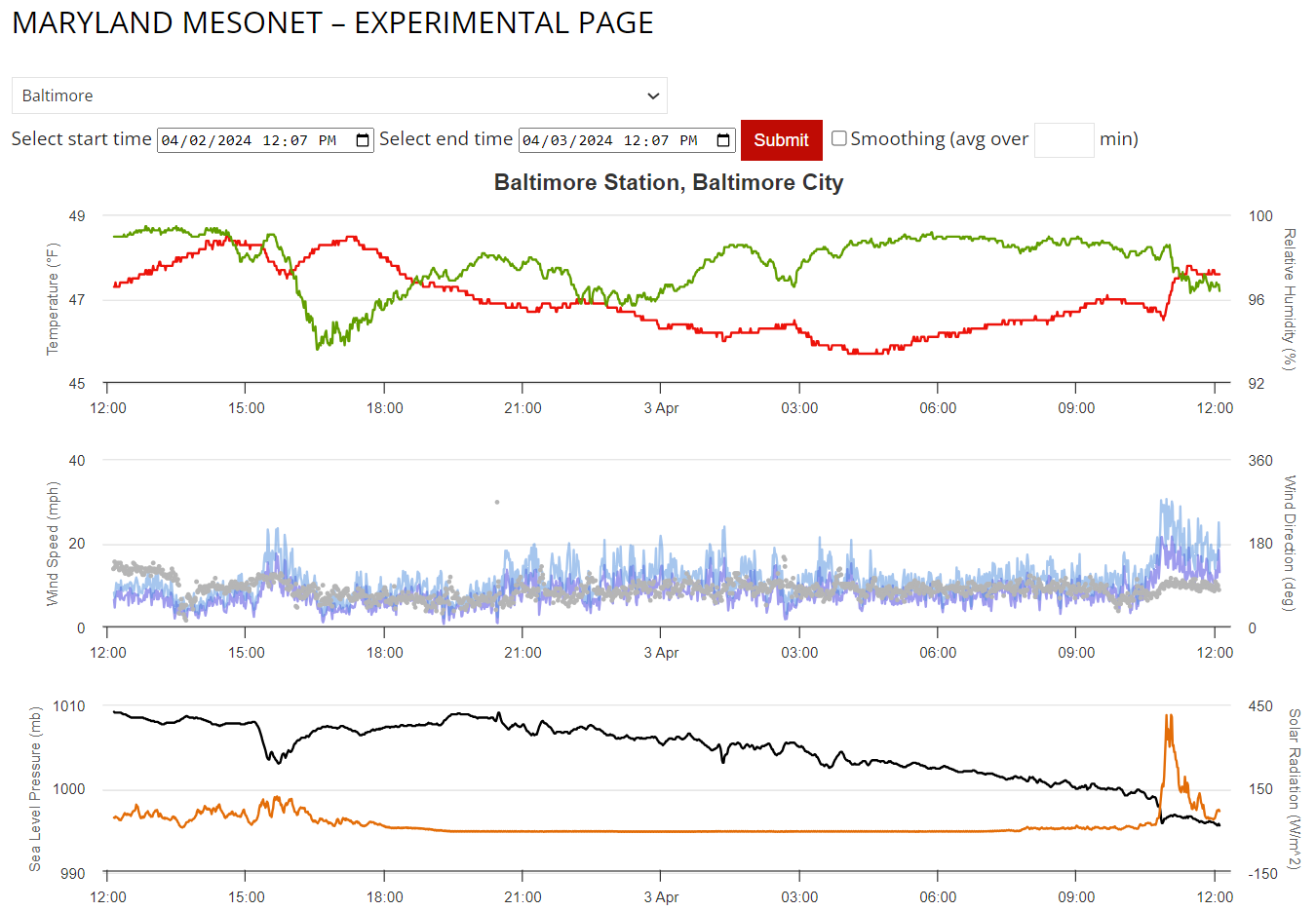
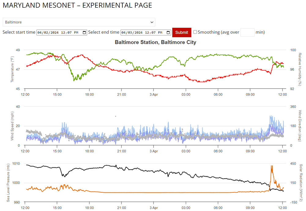
Looks like a wake low spun through Baltimore through NE MD: Check out the temp spike (Red Line), Wind gusts (blue lines), and pressure drop (black line), along with a brief spike in solar radiation from the clearing behind the low...probably from some brief subsidence.
-
We're really wasting a good severe weather day. If we could even manage 2 to 3 hours of legit sun that line trying to form in West Virginia would be cooking.
-
Looks like this thing is racing east. Might be all she wrote for any flooding or severe issues today.