Eskimo Joe
-
Posts
21,922 -
Joined
-
Last visited
Content Type
Profiles
Blogs
Forums
American Weather
Media Demo
Store
Gallery
Everything posted by Eskimo Joe
-

December 22-23, 2022: Warm Rain to Arctic Chill
Eskimo Joe replied to WxUSAF's topic in Mid Atlantic
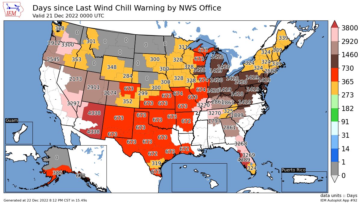
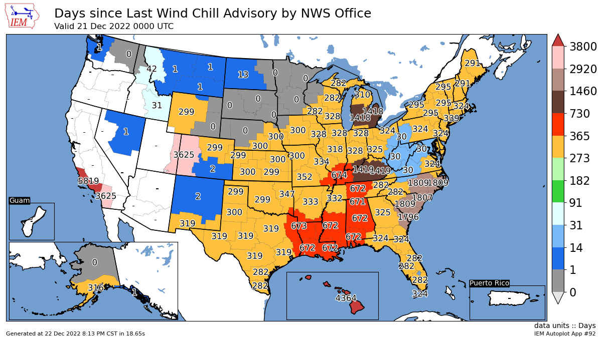
Wind Chill Watch/Advisory/Warning is a long standing product. Prior to today, here is the last time and wind chill product was issued by LWX:
-
December 22-23, 2022: Warm Rain to Arctic Chill
Eskimo Joe replied to WxUSAF's topic in Mid Atlantic
52 in Westminster, 38 in Thurmont. Impressive gradient. -
December 22-23, 2022: Warm Rain to Arctic Chill
Eskimo Joe replied to WxUSAF's topic in Mid Atlantic
Check out that coastal front. Probably reinforcing the wedge a bit west of I-95.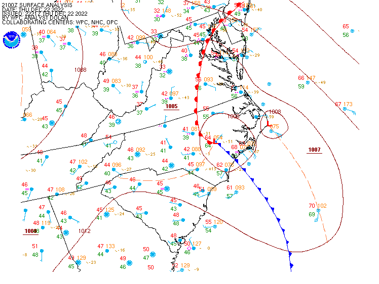
-
December 22-23, 2022: Warm Rain to Arctic Chill
Eskimo Joe replied to WxUSAF's topic in Mid Atlantic
Meso models are absolutely insistently on a core of 925/850 winds hitting Baltimore region around 12z to 15z. Even BUFKIT has some 70 - 90kt winds just off the deck tomorrow morning. -
December 22-23, 2022: Warm Rain to Arctic Chill
Eskimo Joe replied to WxUSAF's topic in Mid Atlantic
RTMA analysis shows a temp of 32 in Indianapolis, IN, and 14 in Gary, IN. -
December 22-23, 2022: Warm Rain to Arctic Chill
Eskimo Joe replied to WxUSAF's topic in Mid Atlantic
The most recently issued product is what is visible "on top". It's like layers on a sandwich. When the "top" product expires, then whatever is "underneath" becomes visible. For example: If NWS issues a Flood Watch at 10:00 am, then a Wind Advisory at 11:00 am, then Wind Advisory becomes visible on the WFO home page. This becomes messy during complicated, changeable storms like the one we are experiencing now, and NWS is aware of this. I've been on a few webinars and completed a few surveys about some possible changes to their interface, and what's potentially coming down the line looks good. I don't know anything else about the nitty gritty. -
December 22-23, 2022: Warm Rain to Arctic Chill
Eskimo Joe replied to WxUSAF's topic in Mid Atlantic
I tell ya, we get a solid 20 - 40 min of snow as things chill, definitely could see a cluster on the roads. Can't salt anything because of the rain. -
December 22-23, 2022: Warm Rain to Arctic Chill
Eskimo Joe replied to WxUSAF's topic in Mid Atlantic
@Ralph Wiggum, your coveted FreezinG Spray Advisory! https://forecast.weather.gov/wwamap/wwatxtget.php?cwa=LWX&wwa=freezing spray advisory -
December 22-23, 2022: Warm Rain to Arctic Chill
Eskimo Joe replied to WxUSAF's topic in Mid Atlantic
Wind Chill Advisory coming out for DC/Baltimore metros. Should populate on NWS website shortly. -
December 22-23, 2022: Warm Rain to Arctic Chill
Eskimo Joe replied to WxUSAF's topic in Mid Atlantic
https://mesonet.agron.iastate.edu/plotting/auto/?q=92 -
Can we please take the bickering to the banter thread?
-
December 22-23, 2022: Warm Rain to Arctic Chill
Eskimo Joe replied to WxUSAF's topic in Mid Atlantic
Yea that front is legit. It's rare to experience temp drops like this east of the Mississippi so it's going to be neat to see. Hopefully we can mange an inch of snow with this flip. Might help us really bottom out. That's seriously amazing. That's some John Muir level of outdoorsmanship. -
December 22-23, 2022: Warm Rain to Arctic Chill
Eskimo Joe replied to WxUSAF's topic in Mid Atlantic
Definitely some wet snow mixing in here in New Windsor. -
December 22-23, 2022: Warm Rain to Arctic Chill
Eskimo Joe replied to WxUSAF's topic in Mid Atlantic
Western folks, please keep these snow pictures coming. I hope you jackpot! -
December 22-23, 2022: Warm Rain to Arctic Chill
Eskimo Joe replied to WxUSAF's topic in Mid Atlantic
IP/SN mix in New Windsor for about 30 min, then sleet and drizzle. Temp 35/29. -
December 22-23, 2022: Warm Rain to Arctic Chill
Eskimo Joe replied to WxUSAF's topic in Mid Atlantic
Starting to think this might be a legit cold front coming out way. -
December 22-23, 2022: Warm Rain to Arctic Chill
Eskimo Joe replied to WxUSAF's topic in Mid Atlantic
Nice -
December 22-23, 2022: Warm Rain to Arctic Chill
Eskimo Joe replied to WxUSAF's topic in Mid Atlantic

-
December 22-23, 2022: Warm Rain to Arctic Chill
Eskimo Joe replied to WxUSAF's topic in Mid Atlantic
Time to move to a more interesting climate. -
December 22-23, 2022: Warm Rain to Arctic Chill
Eskimo Joe replied to WxUSAF's topic in Mid Atlantic
This cold push seems legit. -
December 22-23, 2022: Warm Rain to Arctic Chill
Eskimo Joe replied to WxUSAF's topic in Mid Atlantic
Oh, nice -
December 22-23, 2022: Warm Rain to Arctic Chill
Eskimo Joe replied to WxUSAF's topic in Mid Atlantic
12z Euro/NAM/GFS seems insistent on some little 925/850 wind maximum hitting Baltimore some time between 12z and 18z Friday. Even GFS BUKFIT has some decent winds mixing down to the surface. -
December 22-23, 2022: Warm Rain to Arctic Chill
Eskimo Joe replied to WxUSAF's topic in Mid Atlantic
-
December 22-23, 2022: Warm Rain to Arctic Chill
Eskimo Joe replied to WxUSAF's topic in Mid Atlantic
Both the NAM and GFS have some insane frontogenetic forcing with this fropa tomorrow. Probably going to see a few snow squall warnings as this thing rips through. -
The Feb 2006 storm was indeed a thread-the-needle event. I was at Millersville at the time and remember we scored a few narrow hits that left DC with rain. For the Feb 2006 event, we were supposed to be cloudy with a midday start time, but we woke up to full sun and temps in the mid 30s. Thankfully we narrowly lucked out up there, but I agree, today that storm would be a cold rain. Our climate is broken.