

Eskimo Joe
-
Posts
21,922 -
Joined
-
Last visited
Content Type
Profiles
Blogs
Forums
American Weather
Media Demo
Store
Gallery
Everything posted by Eskimo Joe
-
There are several caveats to this thinking: 1.) population increase has lead to more water usage. 2.) if the snow melts off too fast, it will just wash through the surface collection systems (dams, levees, etc.) We really need a ''normal'' spring.
-
Looks like the pacific jet will flex it's muscles again. We are about a month out from climo peak of snow cover out west. Hopefully they can build on the snowpack for out west and mitigate the summer drought/wildfire risk.
-

2023 Mid-Atlantic Garden, Lawn, and Other Green Stuff Thread
Eskimo Joe replied to mattie g's topic in Mid Atlantic
Plant in December, cover generously with straw. Cut off the first set of skanes that appear. Let the leaves go brown after that but harvest before the stem withers. Use a fork if the ground is hard. Let dry in a shaded, dry space for a week. Cut and clean as appropriate. -
Brief RA/IP mix, now all rain.
-
2023 Mid-Atlantic Garden, Lawn, and Other Green Stuff Thread
Eskimo Joe replied to mattie g's topic in Mid Atlantic
Lawn is slowly waking up. Everything is getting that look of anticipation of leaf out. -
M0.3" for the seasonal total. Winter's over.
-
Beautiful indeed
-
Compared to it's 00z counterpart, the 12z CMC has a much stronger and better placed high over Canada.
-
Graupel and broken snowflakes in Westminster.
-
Once the mesonet stations go in this year, we'll have better access to identifying mesoscale features and supporting warn-on (hopefully!) processes. Really exciting times coming locally to summer weather lovers.
-
We are so due for a crazy flood/severe season.
-
It's 70 at Ft. Meade, 49 at Annapolis.
-
Visible satellite shows low level clouds trying to work southwest along the NJ and DE coasts. This might be an inkling into a back door cold front trying to work down towards Baltimore/Philly/Delmarva. But surface observations show a broad southwest flow at the surface which may limit it's extent. Looks like the HRRR and RAP beat the NAM on how far north the warm sector would advance today. Let's go for 80 degrees!
-
2023 Mid-Atlantic Garden, Lawn, and Other Green Stuff Thread
Eskimo Joe replied to mattie g's topic in Mid Atlantic
Hardnecks are the best. My wife is sicilian so we make our own tomato sauce and when combined with home grown garlic, it makes for one of the best meals you'll ever have. We cannot go back to store brought garlic. -
Big differences for tomorrow temp-wise. NAM keep areas north and east of the Susquehanna River socked in with fog in the low 50s. HRRR gets every SW of Philly well into the warm sector.
-
2023 Mid-Atlantic Garden, Lawn, and Other Green Stuff Thread
Eskimo Joe replied to mattie g's topic in Mid Atlantic
Garlic is doing very well. Hoping for a banner year. -
2023 Mid-Atlantic Severe Wx Thread (General Discussion)
Eskimo Joe replied to Kmlwx's topic in Mid Atlantic
Multiple M0.88" hail reports and 0.5° velocity readings all signaled severe threat. 100% should have been warned. -
2023 Mid-Atlantic Severe Wx Thread (General Discussion)
Eskimo Joe replied to Kmlwx's topic in Mid Atlantic
Beware the February Mid Altantic MRGL.- 2,785 replies
-
- 2
-

-
- severe
- thunderstorms
- (and 3 more)
-
2023 Mid-Atlantic Severe Wx Thread (General Discussion)
Eskimo Joe replied to Kmlwx's topic in Mid Atlantic
Got some lightning in northern Garrett County. LFG!- 2,785 replies
-
- 1
-
-
- severe
- thunderstorms
- (and 3 more)
-
2023 Mid-Atlantic Severe Wx Thread (General Discussion)
Eskimo Joe replied to Kmlwx's topic in Mid Atlantic
2/7/2020 was an incredible MRGL day in these parts. Better than most ENH days. https://www.spc.noaa.gov/exper/archive/event.php?date=20200207 -
Daffodils are blooming. Tulips coming up. Red Maple buds swelling. Happy February!
-
2023 Mid-Atlantic Severe Wx Thread (General Discussion)
Eskimo Joe replied to Kmlwx's topic in Mid Atlantic
Sharp fropa in Gaithersburg. -
Late February will be rocking. February Long range Discussion thread
Eskimo Joe replied to Ji's topic in Mid Atlantic
Euro pumping a 597dm ridge in the Gulf in...checks notes...February.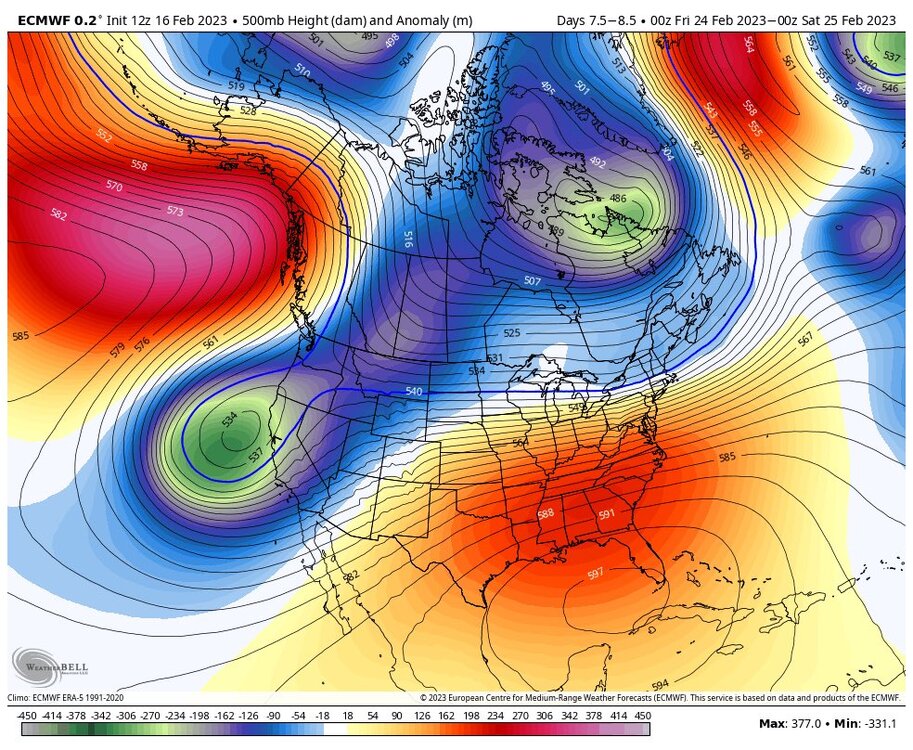
-
Late February will be rocking. February Long range Discussion thread
Eskimo Joe replied to Ji's topic in Mid Atlantic
Backdoor cold front season awaits! -
The wedge always wins. Until it doesn't.


