

so_whats_happening
-
Posts
1,304 -
Joined
-
Last visited
Content Type
Profiles
Blogs
Forums
American Weather
Media Demo
Store
Gallery
Everything posted by so_whats_happening
-
2024-2025 La Nina
so_whats_happening replied to George001's topic in Weather Forecasting and Discussion
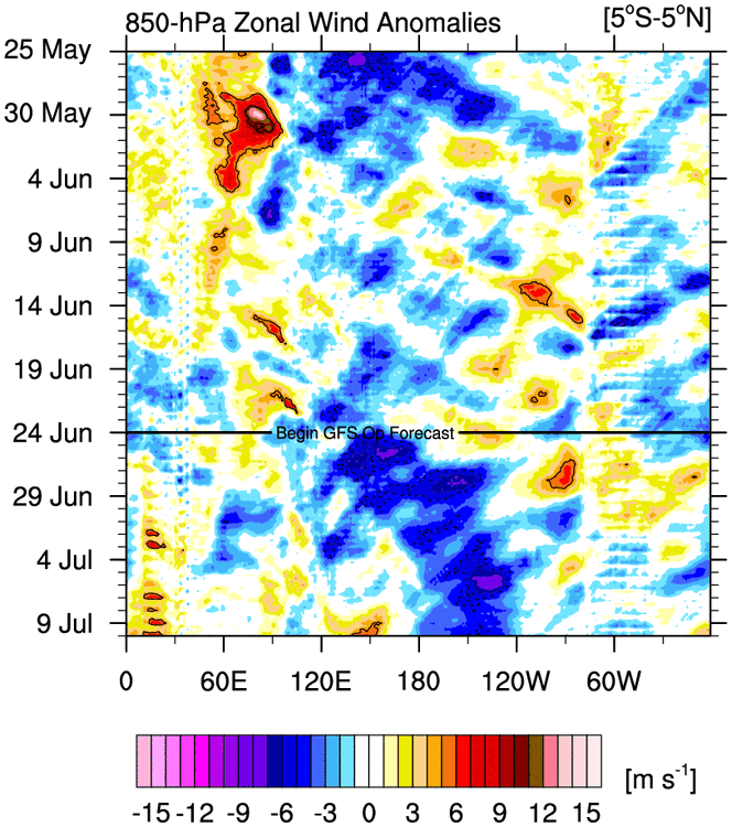
We are starting to see some changes in the far north pacific waters and this Aleutian ridging pattern will only help enhance it. Less Gulf of Alaska low action will allow warming into the NE Pacific over time. I think it is possible we start to actually tame down the -PDO as we head toward winter. Especially if the ridge persists much further east compared to around mainland China to Japan. BTW this is the latest start to the EPAC hurricane season July 2nd was the latest if my numbers are correct.
-
2024-2025 La Nina
so_whats_happening replied to George001's topic in Weather Forecasting and Discussion
Latest update Ill stop adding in May after this one. You can see the surface region cool again properly with the latest easterly trades. We should start to have the early June look again around mid month from there it just depends on how things keep going..thumb.gif.7697e3d148616a13eae7ced72763f8c5.gif)
.thumb.gif.05196b8ed4b8c74b23908b35d27f5489.gif)
-
2024-2025 La Nina
so_whats_happening replied to George001's topic in Weather Forecasting and Discussion
Thanks finally figured out I had to go through some massive amounts of attachments over the years should be good for a little now. Honestly the biggest misalignment Im seeing is the lack of properly placed 850mb. This would have allowed convection further east, VP also to be further east, cooling into the west pac, actual typhoon action in the WPAC, and overall a much more proper 500mb pattern closer to those years. But yes hybrid is probably the best way to describe it. Looking at strictly years with similar SST and -PDO patterns you can even see we were way off. Also looking at past years with strong western leaning forcing still showed we were way off. Im actually kind of amazed we were even able to get a proper +IOD with such misplaced VP. Guess the only way to see if this continues or was a just a fluke incident is to look toward next +ENSO event.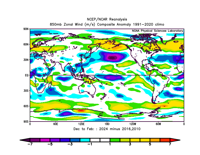
-
2024-2025 La Nina
so_whats_happening replied to George001's topic in Weather Forecasting and Discussion
If you look at just surface temp anomalies you would undoubtedly presume this was a super event it matched almost perfect. So it had flairs of super within a strong Nino state atmospherically. Again I need to say this I don't dismiss RONI for what it is but I do not find it reflective what the atmospheric state shows via RONI. Until we start to see that I still have to go with ONI as the base stat in these situations. This is why I believe it may end up being more useful in these weak and neutral events to help determine that atmospheric mode, but we will get to that in time and see how it handles in the upcoming years. -
2024-2025 La Nina
so_whats_happening replied to George001's topic in Weather Forecasting and Discussion
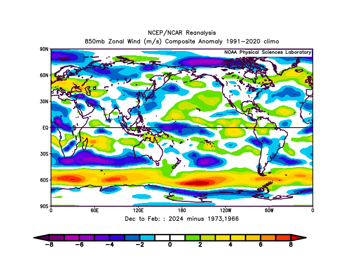
1972-73 had very strong WWBs per 850mb wind zonal anomaly. I think location of these WWBs is the most important factor in cooling the west pacific. The intensity certainly plays a role but placement is probably the bigger factor. 2024 had WWB anomalies much further east than 1965-66, 1972-73, 1982-83, 1997-98, 2015-16. Allowing these years to cool down in the WPAC comparatively where 2015-16 was the odd ball because of just how warm the ONI got in comparison. For SLP comparison yea 2024 was a bit lackluster in that department compared to these years that was probably a solid result of the lack of cooling in the WPAC. As for the 1994-95 and 06-07 comparison, yea I guess you could make the claim they were in a similar-ish PDO state RONI would have had 1994 right at ONI values of 1.1 and 06-07 actually sitting at around .5-.6 (barely ENSO weak status) so im not sure these years can be compared in that sense. Look I get where you are coming from in stating that this was not your traditional Super El Nino but this was not your typical moderate El Nino either. Strong is probably the most befitting and atmospherically it was pretty darn close to strong status. Again wish I could post pics of all this, I did contact stormtracker to see what is up with that. -
2024-2025 La Nina
so_whats_happening replied to George001's topic in Weather Forecasting and Discussion
I really wish I could post pictures right now to show these years comparatively to 2023-24. Also I believe you meant 2006-07 season. -
2024-2025 La Nina
so_whats_happening replied to George001's topic in Weather Forecasting and Discussion
It is a damn shame we can't see back to 1972-73 and 1965-66 for RMM plots. These years had similar patterns of SST anomaly and PDO state (although these years managed to get the PDO to near neutral in winter but were surrounded by a largely negative state). This was the last time we experienced such events coinciding. I would post these 500mb patterns but I cant seem to do more than 98kb, gotta figure this one out. -
2024-2025 La Nina
so_whats_happening replied to George001's topic in Weather Forecasting and Discussion
Interesting read again Im not sure how this can be used in the most recent year. There is simply no way this was a moderate event using a RONI indicator which would have been on the order of .5-.6 cooler if we were using this. Meaning SST anomalies would have settled around ~1.4. Maybe this is a more useful tool in the ENSO neutral/weak states to help better understand the atmospheric mode for regions that are highly affected by the ENSO state. It is different to sit there and say 2019/20 was essentially -.1 to-.2 via RONI though when the atmospheric pattern very much resembled that of an El Nino and the precip pattern was almost spot on to that mode. The only difference was the SST's didn't warm substantially in the central/east Pacific like lets say 1997/98 and 2015/16 did so VP was a bit off around South America versus those years, so locally those regions experienced something different due to the lack of overall warming of the Pacific. -
2024-2025 La Nina
so_whats_happening replied to George001's topic in Weather Forecasting and Discussion
please post would love to read -
2024-2025 La Nina
so_whats_happening replied to George001's topic in Weather Forecasting and Discussion
Im game for whichever metric you would like to use I have no issue with that but when comparing it to ambient weather I have yet to see RONI take the lead in that aspect, ONI still seems like a much more reasonable fit. The bold I would assume you are saying comparing tropics to subtropic or are you comparing one tropical region to a different basin? If waters warm globally the same amount (of course this is not the case but averaging it out) the effects are still felt from an ENSO event but since mid latitudes to the poles are warming much faster than Equatorial regions there has to be some effect that this causes. I think this is what you were maybe trying to allude to? Im just not seeing RONI as the answer for this explanation is all. This year should have acted very similar to 1965-66 and 1972-73 both strong/super in a -PDO state (multi year -PDO surrounding) but it just didnt. It is possible to explain this year may have had extremely bad luck in that the +AMO (which was nearly triple the value we saw back in 1997/98) was to blame? Both 65-66 and 72-73 saw the PDO values go to neutral over the winter versus 82-83, 97-98, and 15-16 where they all were positive. 2015/16 I think was able to get a bit closer to the classic look of strong/super ENSO because it was on another level with SST anomalies. -
2024-2025 La Nina
so_whats_happening replied to George001's topic in Weather Forecasting and Discussion
Im not saying it is the wrong metric if RONI was to be the metric last year it very much should have ended up like a moderate El Nino and it just didn't. The consistency of overstating that this was going to be a super Nino last year per ONI was a lot and yes the RONI was mentioned over time for sure. Was RONI the true metric if so this should have very much acted like a moderate Nino which it actually didn't now we go do down this path so far this year where RONI is still well below the ONI values and now we want to use this as the metric? Im all for consistency but one needs to be used. I personally just see RONI as taking out the background noise of Oceanic warming but water temps are water temps regardless of the surrounding oceanic warmth. I know we had a major discussion on this last year. If the waters are still consistently +2 above normal even with a warmer state the atmosphere should still respond in the same way even at a higher point. -
2024-2025 La Nina
so_whats_happening replied to George001's topic in Weather Forecasting and Discussion
I get what you are saying but im personally not a fan of picking and choosing years for different metrics how we can go from last year using ONI and saying that was the true metric, to this year and saying RONI is the true metric is not befitting. There needs to be consistency. -
Phoenix Experiences its Hottest June on Record
so_whats_happening replied to donsutherland1's topic in Climate Change
Has there been an overall increase in moisture seen over the SW, not necessarily rain but have dew points been higher in recent years to help really push these means higher? -
2024-2025 La Nina
so_whats_happening replied to George001's topic in Weather Forecasting and Discussion
The stronger trades are starting to have an impact on the warming that did occur into the second half of June. This has allowed the thermocline to also rise, but the biggest problem I am seeing is where the extra juice in the tank will come from as we head through summer and into fall for the developing La Nina. It does seem as though things are taking time to establish. We slowly are pushing VP further west to the maritime continent and eroding what little remnants of Nino were left. Just don't know if there will be enough to forcibly put us solidly, even RONI levels, into moderate/ strong like I have been reading. I would like to see some real positive changes to make me think it is reasonable we can attain anywhere near those levels. We saw that this happened earnest last year with the El Nino around end of July into August after months of rather low confidence in the potential. This is also in the wake of me making that prediction of us attaining moderate status via ONI (thinking maybe -1 to -1.2 area at best). Still have plenty of time and would like to see how things react to the upcoming MJO wave movement, which has been extremely stagnant for a La Nina thus far. -
2024-2025 La Nina
so_whats_happening replied to George001's topic in Weather Forecasting and Discussion
Always fun to see what happened a year ago to now. This will change day to day unfortunately because we are locked with how much we can upload a hard copy. 140kb lol -
Arctic Sea Ice Extent, Area, and Volume
so_whats_happening replied to ORH_wxman's topic in Climate Change
You can see the regions that have not had strong ice melt from how the 500mb pattern has setup. The region of the Beaufort was already rather worrisome as we left winter ~1.5 meter thick ice as we were heading into spring spells for bad results in the summer. Strange to see the Kara sea holding up rather well still. I know it is the Navy model some folks do not like but still believe it shows how things are going relatively well.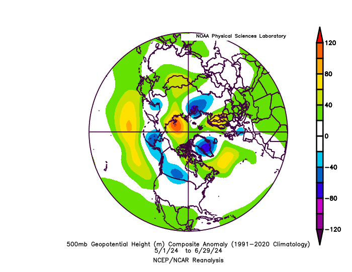
-
2024-2025 La Nina
so_whats_happening replied to George001's topic in Weather Forecasting and Discussion
Huh never took the chance to graph it like this but it is interesting to see that before 1994 RONI was typically warmer than ONI itself. -
DCA _ NYC _ BOS __ ORD _ ATL _ IAH __ DEN _ PHX _ SEA +2.4 +2.2 +2.7 +1.8 +1.2 +1 +1.3 +1.9 +1.1
-
2024-2025 La Nina
so_whats_happening replied to George001's topic in Weather Forecasting and Discussion
Yep and an increase or decrease in cloud cover plays a very important part in radiative balance. Even something as small as 2% can make a large difference, cloud height also plays such an important role. Was discussing with one of my colleagues on the situation (he works with NOAA) they are not even sure what is going on with the rather abrupt increase over the last decade or so. To be higher continuously from a warming average is something we surely have not recorded take place. Truly something interesting to see happen. -
2024-2025 La Nina
so_whats_happening replied to George001's topic in Weather Forecasting and Discussion
Definitely will see the surface cooling as for the subsurface that will certainly be interesting to watch setup. I wish I had hovmollers from back around spring/summer of 2020. -
2024-2025 La Nina
so_whats_happening replied to George001's topic in Weather Forecasting and Discussion
Thanks for the site Ill keep that in my bookmarks. The GODAS has only updated to the 17th so TAO around then was like this. You can see on GODAS it did warm a bit toward the end not as much as what TAO is showing but will be interested to see if it follows suit in the next update (should be later today or tomorrow). Another thing though is GODAS, im pretty certain goes 5N-5S whereas TAO is only 2N-2S so it is showing a fairly narrow band right around the equator versus a broader region which could in fact be cooler over all. Intricacies like this though don't mean much in the broader sense. I would expect TAO to cool in the coming updates as we close out June and July to be a little more inline with scope of GODAS. Especially when seeing the hovmollers actually showing signs of a nice Easterly event through the first half of July. What I also did find interesting from that site is the CFS SST forecast for the western Caribbean, July it is just on fire but as we go through to October/November it cools quite a bit this tells me there is potentially quite the Caribbean hurricane season being projected from that model. Just something to watch going forward.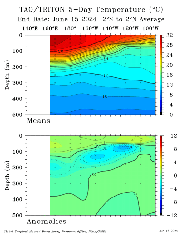
-
2024-2025 La Nina
so_whats_happening replied to George001's topic in Weather Forecasting and Discussion
Here is a comparison date to date 2024 and 1998. I only use TAO as it looks cleaner with displaying purposes versus this which you kind of have to do some extra steps to get a similar look. This site also uses monthly data versus 5 day, monthly, and quarterly that TAO uses. TAO has limitations in date range though as it only goes back to I think 1988. https://ds.data.jma.go.jp/gmd/tcc/tcc/products/elnino/ocean/t-eq_tcc.html This is not to say we are experiencing something completely different as the moving average is still very real, so 1998 would look colder on a warming average (1991-2020 as the current average).
-
2024-2025 La Nina
so_whats_happening replied to George001's topic in Weather Forecasting and Discussion
This is what I use from 1953- present https://www.atmohub.kit.edu/data/qbo.dat -
2024-2025 La Nina
so_whats_happening replied to George001's topic in Weather Forecasting and Discussion
Yea it is still early yet I do wonder still how strong we get though. The Subsurface looks to be warming up again toward the WPAC so it would seem maybe a quick blip into Nina territory. If I had to take a guess this early I would say we could push to -1 to -1.1 area with ONI just not sure it will last all too long yet. Gotta wait to see if the trades do enhance quite a bit. -
2024-2025 La Nina
so_whats_happening replied to George001's topic in Weather Forecasting and Discussion
My guess is due to the WWB event that took place through late May. You can see that trades weakened quite a bit during that time giving a very Nino like response to the ocean. Most sources see that warming that occurred not quite to the levels of TAO and CPC T depths did warm a little at the surface. That should erode rather quickly if we do indeed see trades strengthen coming up here into early July.

.gif.5e44fbb4b88b16f31e07c5ec3808d7c1.gif)
.gif.8147d9ce7b5840c69ab093f13f852566.gif)


