

StormchaserChuck!
-
Posts
2,273 -
Joined
-
Last visited
Content Type
Profiles
Blogs
Forums
American Weather
Media Demo
Store
Gallery
Posts posted by StormchaserChuck!
-
-
-PNA, bet on it.
-
 1
1
-
-
I thinkwe are still due to see a pop in activity.
-
2 hours ago, bluewave said:
While record ridges have been dominating, models have a rare -4SD near record trough for the SW next week.


400dm -PNA, I went back to 1948, and only Strong Nino's/Nina's had it (4SD). It's dissolving...
-
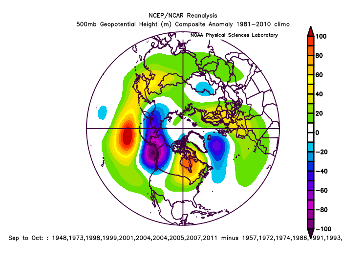
-PNA is record setting. +400dm coming up. This Sept/Oct is going to be most -PDO, meaning Aleutian ridge/GOA trough since satellites in 1948.
The Winter composite is Global warming skew... this is 8plus years and 8minus years. Warm in the mid-latitudes~ This agrees with trend of this last few years. Slight chance for a -NAO this Winter, but when it happens it may be accompanied by a stronger +EPO/-PNA


-
That is a good point about longest streak of 10 years without deep La Nina..
-PNA is record setting, +400dm coming up. This Sept/Oct is going to be most -PDO, meaning Aleutian ridge/GOA trough since satellites in 1948. The analogs are Strong El Nino's and Strong La Nina's, 04-05 broke the trend, moving to -PNA, it's 65% Strong events(+/-). But this is as "deep Nina" as we are going to get (models through October). -400dm -PNA, and close to -200dm for a Sept/Oct composite.
-
-PNA is record setting. +400dm coming up. This Sept/Oct is going to be most -PDO, meaning Aleutian ridge/GOA trough since satellites in 1948.
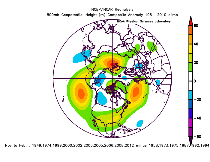
November analog carry the trend, as does through February, -PNA...
-
-PNA is record setting. +400dm coming up. This Sept/Oct is going to be most -PDO, meaning Aleutian ridge/GOA trough since satellites in 1948.
The Winter composite is Global warming skew... this is 8plus years and 8minus years. Warm in the mid-latitudes~

-
-
NAO is a little displaced in -QBO/Nina
vs +QBO/Nino https://ibb.co/Fk10XH0
-NAO over northern Europe in Nina, +NAO south of Iceland in Nino.
10mb-Nino/Nina
-
20 hours ago, frd said:
Some of the warmest Octobers on record have produced this in the following Novembers.
Big +PNA 2020, Big -PNA 2019 same time.
-
Did somebody say Seattle? https://ibb.co/gwx7BKL
-
The real pattern is probably +NAO/+PNA, behind all the clutter
-
If you really think about it, energy given off by cyclones is absorbed to .01 pretty quickly lol, It's more of "satilite catching".
-
Pretty cool, it's in the low SLP part of the -NAO.
-
44 minutes ago, Allsnow said:
October is really the best month of the year.
It's the most stable probably. Never has ENSO changed direction in October.
-
 1
1
-
-
I would love to see if the Solarascencion> breaks a little next year. ACE with this Sam is going to be high, and 2017 was top-- negNAO in Dec/Jan cold Europe Feb/Mar. despite warm conditions.
-
Yeah, I was saying about 9 more.
-
^spells a big MidAtlantic hit.
-
 1
1
-
-
3 rounds of -PNA coming, 10-3, 10-8, 10-12
-
1 hour ago, CAPE said:
October edition of the CanSIPS.
Wow, yeah. I expect February to especially be -PNA, with a 99% chance. We may get +PNA around 2-21 though.
-
Just more stuff.. the -PDO intensification-PNA/+EPO through the first 15 days of October, Oct1-15, will be as extreme as it gets.
Monthly analogs
-
10 hours ago, Windspeed said:
Not bad, Sam.
Reminds me of when all the storms were in the NEAtlantic, near Europe a few years ago.
-
I wouldn't be surprised if we break into the 80s here in early October.
-
2 minutes ago, 40/70 Benchmark said:
It requires a microscope to read that composite.
It's like all -PNA>0.0 /+EPO in October vs opposite in La Nina. I expanded it a bit. The research I did yesterday was pretty interesting.

Winter 2021-22
in Mid Atlantic
Posted
It's not even really a Nina.