

StormchaserChuck!
-
Posts
2,274 -
Joined
-
Last visited
Content Type
Profiles
Blogs
Forums
American Weather
Media Demo
Store
Gallery
Everything posted by StormchaserChuck!
-
It's not even really a Nina.
-
-PNA, bet on it.
-

2021 Atlantic Hurricane season
StormchaserChuck! replied to StormchaserChuck!'s topic in Tropical Headquarters
I thinkwe are still due to see a pop in activity. -
400dm -PNA, I went back to 1948, and only Strong Nino's/Nina's had it (4SD). It's dissolving...
-
-PNA is record setting. +400dm coming up. This Sept/Oct is going to be most -PDO, meaning Aleutian ridge/GOA trough since satellites in 1948. The Winter composite is Global warming skew... this is 8plus years and 8minus years. Warm in the mid-latitudes~ This agrees with trend of this last few years. Slight chance for a -NAO this Winter, but when it happens it may be accompanied by a stronger +EPO/-PNA


-
2021-2022 ENSO
StormchaserChuck! replied to StormchaserChuck!'s topic in Weather Forecasting and Discussion
That is a good point about longest streak of 10 years without deep La Nina.. -PNA is record setting, +400dm coming up. This Sept/Oct is going to be most -PDO, meaning Aleutian ridge/GOA trough since satellites in 1948. The analogs are Strong El Nino's and Strong La Nina's, 04-05 broke the trend, moving to -PNA, it's 65% Strong events(+/-). But this is as "deep Nina" as we are going to get (models through October). -400dm -PNA, and close to -200dm for a Sept/Oct composite.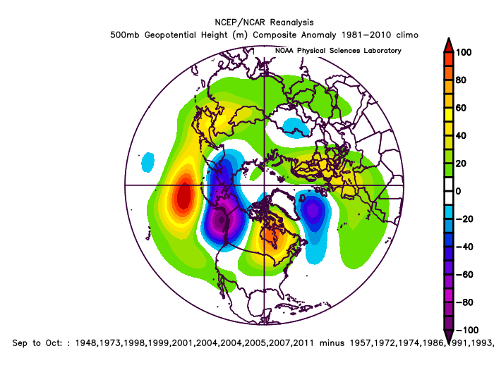
-
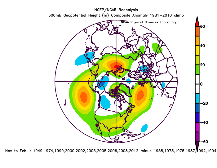
-PNA is record setting. +400dm coming up. This Sept/Oct is going to be most -PDO, meaning Aleutian ridge/GOA trough since satellites in 1948. November analog carry the trend, as does through February, -PNA...
-
-PNA is record setting. +400dm coming up. This Sept/Oct is going to be most -PDO, meaning Aleutian ridge/GOA trough since satellites in 1948. The Winter composite is Global warming skew... this is 8plus years and 8minus years. Warm in the mid-latitudes~

-
6 analogs OctoberPNAMatchQBO/ENSO https://ibb.co/wM6hTcg NOv https://ibb.co/QNh1QpZ
-
NAO is a little displaced in -QBO/Nina https://ibb.co/YRVVXVH vs +QBO/Nino https://ibb.co/Fk10XH0 -NAO over northern Europe in Nina, +NAO south of Iceland in Nino. 10mb-Nino/Nina https://ibb.co/cvRf6R7 https://ibb.co/DMNcd0S
-
Big +PNA 2020, Big -PNA 2019 same time. https://ibb.co/5rL8Z76 https://ibb.co/rMdPNq7
-
Did somebody say Seattle? https://ibb.co/gwx7BKL
-
The real pattern is probably +NAO/+PNA, behind all the clutter
-
2021-2022 ENSO
StormchaserChuck! replied to StormchaserChuck!'s topic in Weather Forecasting and Discussion
If you really think about it, energy given off by cyclones is absorbed to .01 pretty quickly lol, It's more of "satilite catching". -
Pretty cool, it's in the low SLP part of the -NAO.
-
It's the most stable probably. Never has ENSO changed direction in October.
-
2021-2022 ENSO
StormchaserChuck! replied to StormchaserChuck!'s topic in Weather Forecasting and Discussion
I would love to see if the Solarascencion> breaks a little next year. ACE with this Sam is going to be high, and 2017 was top-- negNAO in Dec/Jan cold Europe Feb/Mar. despite warm conditions. -
2021 Atlantic Hurricane season
StormchaserChuck! replied to StormchaserChuck!'s topic in Tropical Headquarters
Yeah, I was saying about 9 more. -
^spells a big MidAtlantic hit.
-
3 rounds of -PNA coming, 10-3, 10-8, 10-12
-
Wow, yeah. I expect February to especially be -PNA, with a 99% chance. We may get +PNA around 2-21 though.
-
Just more stuff.. the -PDO intensification-PNA/+EPO through the first 15 days of October, Oct1-15, will be as extreme as it gets. Monthly analogs https://ibb.co/PYc0GLZ https://ibb.co/kSJL5BT https://ibb.co/2Mrf9NC https://ibb.co/LtTx9vD
-
Reminds me of when all the storms were in the NEAtlantic, near Europe a few years ago.
-
I wouldn't be surprised if we break into the 80s here in early October.
-
2021-2022 ENSO
StormchaserChuck! replied to StormchaserChuck!'s topic in Weather Forecasting and Discussion
https://ibb.co/6nhxKdt It's like all -PNA>0.0 /+EPO in October vs opposite in La Nina. I expanded it a bit. The research I did yesterday was pretty interesting.


