

StormchaserChuck!
-
Posts
2,274 -
Joined
-
Last visited
Content Type
Profiles
Blogs
Forums
American Weather
Media Demo
Store
Gallery
Posts posted by StormchaserChuck!
-
-
It does look like on the 6z GFS ensembles at 384, we are getting ready for -NAO, and maybe -EPO, cold blast.
-
looks like a warm December.
-
 1
1
-
-
+AAM, these are Earth's rotation, associated with +ENSO. I always like to monitor AAM events, because they are associated with gravity waves, rotation differences, etc.. in theory. This state is usually more associated with +ENSO, and I think it's correlated to the subsurface warming. I wonder if we will get a 2nd +push under 165W in about ~14 days.
-
Have to keep this in mind.. in the last 4 months (Aug-Nov) we have run opposite of 2020 at a top 5 highest neg correlation since 1948.
-
2 hours ago, bluewave said:
I know we talk a lot about El Niño and La Nina. But there seems to be another factor that has been influencing the pattern of our monthly departures. A monthly departure pattern that has been regularly repeating since 2010. We are all familiar with how warm September and a October has been over this period. But this turn to cooler has been a regular feature in November. Notice how closely this November has matched the 2010-2020 composite.
It's also interesting that we have been running opposite of last year now 4 months in a row, both at 500mb and on the surface. The correlation is >75% each of the 4 months so it's a pretty good anomaly.
-
I thought last year was ripe in the PDO for -PNA, this Winter it's fizzling. Look at this, an attempt at +AAM
-
On 2/19/2021 at 10:58 AM, StormchaserChuck! said:
Powerful, Nina's going to even out though.
biggest -PNA in a long time happening Dec 4-6, let's see what it correlates to in the subsurface.. looks like a pretty solid transition from -ENSO to +ENSO..
-
That's one heck of a -PNA.. Dec 4-6. Almost breaks +480dm, it might in verification.
Edit: I think this means no Stratospheric warming till at least Dec 10th, which means less -NAO signal until ~jan10th, fwiw
-
 1
1
-
 2
2
-
-
Honestly, I just want to talk about the weather. It's interesting.
-
WxUSAF deletes all my posts in this forum.. doesn't matter what it is. recently it's just been about a model that no one talked about.
-
Dec 4th -PNA in the last 15 years.
We are also going full on +ENSO on the dailies for February or March. Because we have -NAO tendency this year, I think an El Nino next Winter would make 09-10 a good analog. We may blast the Pacific Jet this year though.
-
2
-
-
We'll have a -NAO, but we haven't been below average in -NAO in like 20 straight time.
-
-
1995 is the only other recent year that had warm subsurface+anomalies, while Nina at the surface. All of my analog methods said -PNA, but we'll see, they were just roll forward. +EPO pattern 19-20 and 18-19 analogs is strong imo.
Good example of opposite example https://ibb.co/d2JGy2n
-
It's a good -NAO, but we are going to need more than this for a good Winter. How did we do recently, get some good snowstorms in the last 10 years?
-
Kind of a weak-NAO to be honest.. something like 20 straight -NAO's have been with -PNA or +EPO
-
 1
1
-
-
35 minutes ago, uncle W said:
if you look at 2017-18's daily AO it snowed most of the time the AO was negative big time or briefly...
I'm starting to feel like we are due for a little bit of a wetter pattern.
-
57 minutes ago, bluewave said:
The La Niña vortex in the Northeast Pacific this fall has been the strongest on record since the 1990s. The only other La Niña falls that came close were 2016 and 2011. But 2011 had the vortex further north near Alaska. This year is further south near the Pacific Northwest like 2016. The fall blocking near Greenland this year is closer to 2016 than 2011. So it’s important to see where the La Niña vortex sets up in December and how much blocking we get on the Atlantic side. Long range guidance is hinting that the Niña vortex may try to move over to the -PNA region.
Now in the ENSO subsurface we have all warm anomalies. I'd love to see if there are examples of an ENSO state that had an opposite anomaly dominant in the central subsurface during November... 1988 is the only example I can think of (opposite). We all know 88-89 was a really Strong Nina. and there was actually high pressure from Japan to SE US all through Winter 87-88. Skewed averages puts subsurface warmth at probably ~0.0 now though.
-
+PNA now evolves to +EPO then -PNA, it was what, 74 yesterday?
-
In the subsurface, the La Nina is about dead. It's mostly warm.
-
Most important is PNA/EPO over NAO/AO.
I can feel WPO> NAO/AO too
-
1
-
-
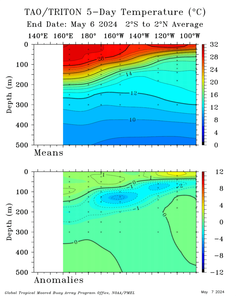
Cold water all but gone from the subsurface, as per the TAO/Triton maps
-
Still like ~Dec 5th for a storm.
-
1
-
1
-
1
-
-
the subsurface will start cooling in 2 weeks. https://ibb.co/233ND55
November 2021 temperature forecast contest
in Weather Forecasting and Discussion
Posted
+5 in the SW, wow, 1995-on has really been a High pressure bubble