

StormchaserChuck!
-
Posts
2,273 -
Joined
-
Last visited
Content Type
Profiles
Blogs
Forums
American Weather
Media Demo
Store
Gallery
Posts posted by StormchaserChuck!
-
-
0c subsurface touching 150W.. not going to redevelop into Weak Nina territory in the subsurface, surface will probably go positive in March or April.
-
 1
1
-
-
Recently
-
6z GFS ensembles are really strong with +EPO.. step outside now it's 60. This will be the pattern for the next 2 weeks.
-
9 minutes ago, blueberryfaygo said:
Why?
-PNA/+NAO. I watch for 15 years that the indexes in the medium range preceded local trends.
-
3
-
-
Expect the warmer solutions to win out from now until Christmas.
The good news is we are kind of doing a February pattern now, so February may be more +PNA.
-
4
-
-
Remember I did that winter research that said we would have more +anomalies overall this Winter
-
Nothing has outdone GFS ensembles or Euro from 2013. Those Euro weeklies have to have some other purpose. I like the warmth in northern Europe/Russia at Day 14-15, but it's starting to evolve wrong the last 1-2 runs. Sometimes lately the Northern Europe warmth has been +time correlated with SE ridge, instead of -NAO.That's why I ask if there's a 10mb warming signature with it (probably not, also the last 21 -NAO's have been -PNA or +EPO).
-
 1
1
-
1
-
-
Yeah, this -PNA/+NAO coming in is really strong. Probably sustained 70s. Too bad all the leaves fell off the trees in the last 1-2 weeks.
-
 1
1
-
-
Expect the models to trend warmer regarding winter wx threat. I've never seen such a -PNA/+NAO produce something good. I say max high gets to 72. Sorry for being repetative. It does look at 500mb Day 13-15 a 10mb Stratosphere warming wants to develop, which would agree with my -NAO January analogs. Also, if January is to get cold it would usualy be cold around Christmas.
-
 1
1
-
1
-
-
Pretty sure we'll bein the 50s/60s consistently.
-
1
-
4
-
-
These strong -PNA's/+NAO overperform, we will be in the 60s consistently easy. Maybe 70+
-
let's see
-
18z GFS ensembles hit +480dm average
-
I know it's a La Nina pattern and La Nina STJ, but the subsurface is not cold..
-
Sure, thanks. Do I get more attachment space? (I think I forgot my password once). I kind of use this as a research forum, so all of the previous attachments have some research value, I think. (If I dont get to merge attachement space, I would rather switch over accounts.)
-
On 11/26/2021 at 11:36 AM, StormchaserChuck! said:
It does look like on the 6z GFS ensembles at 384, we are getting ready for -NAO, and maybe -EPO, cold blast.
Maybe we'll get something around Christmas (refering to 12z GFS LR..
-
Since I posted this, WxUSAF has deleted 24 posts in the Mid-Atlantic forum. only 1/25 survived, that PSUhoffman quoted.
-
1
-
-
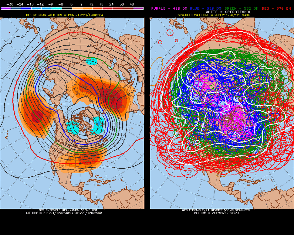
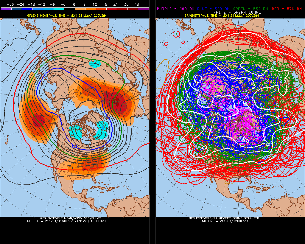
Also that -PNA reloads to +360dm 3 times (maybe even 4 at 336hr). I'm not sure that's something that usually switches direction in the rest of the Winter.
-
-
Through Dec 12th, perfect opposite correlation continues. 8a — ImgBB (ibb.co) (We have a strong -PNA/+NAO pattern coming up)
August-Dec12th, last year and this have such a high negative correlation, it's greater than any 2 5month consecutive periods since 1948. #1 as an opposite match since 1948, 2020 - 2021. I wonder if this will continue into the Winter...
-
The good news is we continue running opposite of last year, all the time since August,-perfect opposite. Dec 2-12 -PNA/+NAO heavy on models:
-
I bet this East Coast trough doesn't verify
Adjust your forecasts accordingly.
-
We'll be over/under +0.3c in Nino 3 in April
-
If November was -6 in the SW, I'd be getting ready for a big Winter here in the NE.
December 2021
in New York City Metro
Posted
Good post.. I wonder if any other place has gone 85 years, then blown past it like this. I remember you posted about AK record Summer warmth by 2 degrees, and PHX the next year record warmth by 2 whole degrees.