MDstorm
-
Posts
1,872 -
Joined
-
Last visited
Content Type
Profiles
Blogs
Forums
American Weather
Media Demo
Store
Gallery
Everything posted by MDstorm
-
Charge your phone
-
Steady snow here for the last 2 hours. Radar not as generous just to my north. Living on the edge can be dangerous. Hoping to cash in here in Western HoCo with banding.
-
NAM is getting “bonkers”, too. May have to add “NAM” to your T-shirt, lol.
-
Look at the snow fall distribution. The Euro must really be feeling the effects from the developing 50/50 low/convergence. This "squashes" the snow fall from NE to SW. We will see over the next 12 -24 hours as the 50/50 low sets up if the perceived effect of the 50/50 low is being over-estimated allowing heavier snow to creep more northeast.
-
lol….. not this time, Commanders.
-
Ravens outgained the Steelers and exhibited a defense that bent, but did not really break. However, as frequently happens, the Ravens beat themselves (this time with missed field goals, penalties, and very costly turnovers). I don’t know if it’s the coaching, talent, or poor practice routines. Really good teams don’t beat themselves.
-
The anomalously dry Fall continues. The last time we had such a dry Fall was in 1963. If only that analog worked out for the upcoming winter
-
I read the thread and realized the analogs that were being used were quite different in terms of sensible weather in these parts. I just thought it was interesting to surmise a +TNH/-WPO/-EPO pattern which could lead to a serviceable winter (as opposed to all of the La Niña —-this winter is going to suck talk).
-
https://x.com/webberweather/status/1842599164544192630?s=46&t=7YEptxkR3LfH8Sv9sPDbpg
-
Where are we going?
-
As good as U Conn is in basketball, it looks like football helps them revert to the mean, Go Terps.
-
Torrential downpours for the last hour here. Some lightning and thunder, but no wind.
-
If a couple tenths lead to shock and ecstasy, what will 15-20 times that amount do to you?
-
WxUSAF bullseye
-
The GFS and ICON each have very different evolutions of how Debby plays out. I would say each model is on its own island at this point with the GFS most likely on Gilligan’s Island.
-
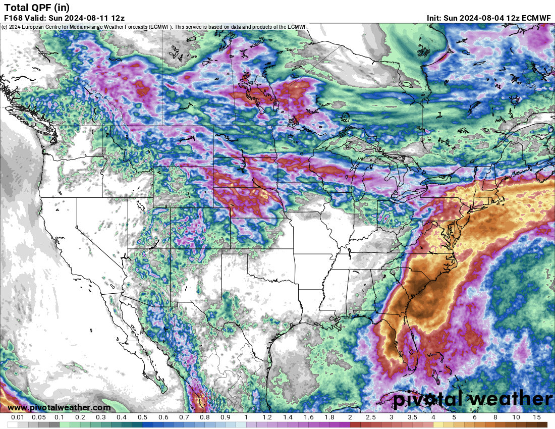
12z Euro is a soaker.

-
Reading this thread over the last few weeks, I have come to the following conclusions:

-
.png.2f43c8e79080e1d495dcdeb04e4a2ead.png)
-

Presidents' Day Storm of 1979 -- Most Memorable Snowstorm Ever
MDstorm replied to RodneyS's topic in Mid Atlantic
I was a youngster when that storm occurred. However, I distinctly remember that on Feb 17th (24-36 hours before the storm even began), AccuWeather was the first to see the possible magnitude of this storm. The NWS and most private forecasters were not making a big deal about the storm. Channel 11, which used AccuWeather at that time came on the air on the evening of Feb 17 and reported a "storm" dropping in from the Ohio Valley looked to explosively re-develop off the NC coast and result in a major snowstorm. The following morning (Sunday), everyone's favorite met, Joe Bastardi, was on the radio and was quite emphatic about the huge potential of that storm (he did nail that one, ). There was one private forecaster on the now defunct WCAO radio station who said during the morning of Feb 18th that he was not overly impressed with the storm, but later came back on in the afternoon and stated that he was stunned by the latest information that he had seen and he was all in for a big storm. (I don't think that it was the RAP or HRRRRRR ). Anyway, with up to 4 inches of cold powder per hour for a few hours, the snow piled up to historic levels and I had over a week off of school. -
The Weekend Rule? Saturday 2/17 - The Icon Storm
MDstorm replied to DDweatherman's topic in Mid Atlantic
Looks about right. That small darker blue dot in northern Carroll County must be PSU. -
The Weekend Rule? Saturday 2/17 - The Icon Storm
MDstorm replied to DDweatherman's topic in Mid Atlantic
After a couple of hours of light/small flake snow, the Sn++ has arrived. -
2024 Valentines Day Who the Hell Knows - Comeback Thread
MDstorm replied to DDweatherman's topic in Mid Atlantic
There was a time when the Ukie seemed to hint at what King Euro would show next. -
Stuck in 7. However, it looks like our best week of winter weather so far has occurred in phases 4 and 5 (supposedly the crap phases). So much for mjo dictating our winter weather.
- 2,509 replies
-
- 1
-

-
- weenie fest or weenie roast?
- weenies got roasted
- (and 2 more)
-
Poor playoff history is now history.