NCBlizzard
-
Posts
665 -
Joined
-
Last visited
Content Type
Profiles
Blogs
Forums
American Weather
Media Demo
Store
Gallery
Everything posted by NCBlizzard
-
Yep, been stuck in that hole for a while here in south Durham. I noticed it on the HRRR but hoped it was a fluke. Overall, had a brief rain/snow/sleet mix early this morning 5-6 am, leaving a trace on elevated surfaces. Then a rain/snow mix since 7:30. I didn't have my hopes too high overall though. And you're right about the Triangle being really lucky the past several years. Can't complain much at all given that.
-
Transitioned from a mix to all rain in south Durham (near Southpoint mall for those familiar) an hour or so ago. 34.9 currently, which is about 1-2°F cooler than the NAM/HRRR forecast for 8AM.
-
Rain/snow/sleet mix in South Durham. Temperature has dropped to 36.7.
-
While every model was too warm with dew point/wet bulb temperature here at my place in Durham, still just a cold 33° rain. Below is the forecast dew point error for 9 AM compared against the 32.7°F recorded at my station: HRRR +0.8° GFS +1.1° RGEM +2.2° NWS NDFD +2.3° NAM +2.3°
-
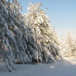
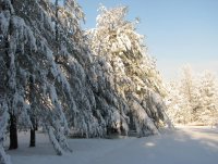
I'm near Southpoint Mall and all snow. It's really coming down. My station is reading 34 and wet bulb is almost to 32 Sent from my SM-G975U using Tapatalk
-
I noticed as well, and the same is happening at my house with the dewpoint dropping at -2.8°/hr now. There seems to be a stretch of locally higher DP through parts of S Orange, S Durham, and W Wake county but hopefully that disappears quickly. NAM dewpoint forecast was about a degree higher at 8AM that what I measured with my station.
-
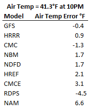
For my house in S. Durham, the NAM is way warmer than the current air temperature, with GFS/HRRR being the best right now.
-
There is a snow melt forecast variable, which I assume accounts for things like ground/air temperature, and that would be incorporated to calculate the snow depth. I also believe it accounts for snow density/compaction. I'm not sure of the overall accuracy. You can see all of the forecast variables here: https://www.nco.ncep.noaa.gov/pmb/products/nam/nam.t00z.bgrdsf00.tm00.shtml
-
I think it at least starts with what they call the "National Blend of Models" that is then adjusted by individual offices before the forecast data actually goes into NWS NDFD forecast grids. Here's a a link to some info about that: https://www.weather.gov/mdl/nbm_about and you can also see the text output for the NBM for airports across the US by navigating through this directory: http://nomads.ncep.noaa.gov/pub/data/nccf/com/blend/prod/