
NCBlizzard
-
Posts
665 -
Joined
-
Last visited
Content Type
Profiles
Blogs
Forums
American Weather
Media Demo
Store
Gallery
Everything posted by NCBlizzard
-
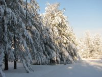
Measured an additional 1" fresh snow today. As others mentioned - the flake sizes were incredible. Event total of about 4.2". Awesome system!
-
3" now at a cozy 24.4°F. As of about 15 minutes ago - at least 30-40% of what is falling is now graupel (I don't think it's quite sleet), perhaps as the DGZ is slowly drying out. Not sure. Beautiful wintry day though. Best in many years.
-
February 19-20 Major Winter Storm Threat
NCBlizzard replied to NorthHillsWx's topic in Southeastern States
HRRR initialized snow depth looks reasonable, and paints a pretty picture for the next 6 hours for many in Triangle east/NE -
Transition line right now definitely shifting east on CC. Hopefully those mixing get pure snow here very soon!
-
I actually did mow mine haha - even though I wasn't too optimistic. Right at 2" here 2 mi. NNW RDU. Temp is 25.3°
-
I'm feeling that if you're super close to the transition line now or just on the sleet side, that is not a bad spot to be given the enhanced precip build back to the west continuing more than progged and inevitably the transition line collapsing SE as WAA shifts.
-
I was just actually thinking through this ha. It seems there is indeed technically a difference, with graupel having notably more structural change to the crystal structure under heavy rime. Delicate balance for sure
-
I'm always pessimistic with regards to sleet, but my gut says the sleet line may come a little further north than it is now - but quickly like within 1-2 hours stall and start progressing more eastward as more CAA takes over from NW.
-
I noticed some rimed flakes an hour or two ago, but right now just massive fluffy flakes. Roughly an 1" here but rates have increased tremendously
-
Here near RDU, treated roads becoming solidly covered. Few car accident near Glenwood/Page Rd. It's getting messy for sure
-
Likewise, ha!
-
Massive flakes falling now here 2 mi N of RDU. Temp is down to 26.1°F. RDU reporting 1.0 mi visibility. Sidewalks are finally starting to cover now (as long as the rate holds) but still nothing on asphalt. It's a beaut.
-
1.5" here 2 mi NW of RDU. 19°F low. Beautiful outside.
-
Light snow (quite small flakes) here just north of RDU. Starting to have a dusting cover on cars/elevated surfaces. Station reading: 24.2°/12.2°F.
-
The fact that our (RDU area) 'true' snow drought hasn’t ended (in my opinion) makes even the thought of 0.5” of pure fluff feel phenomenal. No sleet, no ZR—just snow. Fingers crossed here in Durham! I’m oddly optimistic—given the fact that the trend we need is usually the one we hate yet always get. Fully prepared for disappointment, but honestly, this—checking the threads, intermittently checking the models, getting a brief rush of possibilities, and just thinking about snow—is so much better than the bleak 2021-2024 stretch when winter felt like nothing more than cold rain and bare skies, waiting for the blooms to pop open.
-
1/10-11 super awesome winter SE OBS thread
NCBlizzard replied to strongwxnc's topic in Southeastern States
Massive snowflakes the past 30 minutes. Recorded 0.5" about 20 minutes ago. As of 7 PM here just NW of RDU: Wet bulb temp of 26.5°F GFS +0.4°F warmer than observed NAM: +0.1°F HRRR: +0.5°F HRRR Subhourly: +1.1°F RDPS: -1.2°F GDPS: -1.7°F -
1/10-11 super awesome winter SE OBS thread
NCBlizzard replied to strongwxnc's topic in Southeastern States
Light snow starting to cover surfaces. HRRR subhourly valid for 4:45 PM at my location (2 mi. NW RDU) was Ta 34.3° (actual 32.2°) with a wet bulb of 27.4° (actual 27.3°) -
1/10-11 super awesome winter SE OBS thread
NCBlizzard replied to strongwxnc's topic in Southeastern States
As of ~4 PM, my weather station recorded a temperature of 28.2°F (~2 miles NW of RDU). Compared against model forecasts for this time: NBM: +1.2°F (1.2°F too warm) GFS: +0.1°F GDPS: -0.1°F HRRR: -0.9°F RDPS: -1.0°F NAM: -1.2°F -
Ended up with about 3.75” total here 4 miles north of RDU (measured every hour or so on a snowboard). Measuring on the board where I didn’t clear off throughout the storm, the actual snow depth is about 3” due to compaction and wind. Great storm! Beautiful out
-
Closing in on 4" here about 4 miles north of RDU. Rates were incredible there for a bit under that last band. Definitely overperformed my expectations!
-
Also beautiful here. Just did similar myself taking the dog for a walk. Roads are totally covered. As I was walking back inside, a cop came whizzing by and a minute later I heard sirens, so I figure it's slick out
-
Closing in on 0.25" here about 4 miles N of RDU. Total snow depth (i.e., also including what fell last night with the front) is 0.5". Snowfall rates quickly picking up. Air temp is down to 23.5
-
Winter Storm Izzy Obs Thread
NCBlizzard replied to Prismshine Productions's topic in Southeastern States
About 1/4" snow before the changeover here about 3 mi. north of RDU. Freezing rain starting to mix in with the sleet now... was hoping to stay mostly sleet a bit longer -
February 18-19 MAJOR Ice Storm Threat
NCBlizzard replied to NorthHillsWx's topic in Southeastern States
I’m at 31.3 with a wet bulb of 30.2 in South Durham, right at I-40. A solid glaze on elevated surfaces/trees (maybe 0.05”), but sidewalks and roads are just wet. I’m surprised we got this cold here based on trends late last night. At 9 AM, my station was 2.2°F colder than the NAM and 1.4°F colder than the HRRR projected. Some more light precip moving in now so we’ll see if those trends mean anything at this point. Oddly enough, GFS/RDPS have been the most accurate on temps so far. -
I agree it definitely runs colder, and sometimes by a lot. At the very least, it seems to run 2-4°F too cold on average. RGEM forecast low for tonight here is 15, which is 6 degrees cooler than the NWS forecast and around 10 degrees cooler than all other models except the Canadian. I have a hard time believing we get to 15 here, but we shall see…

