

Itstrainingtime
-
Posts
19,381 -
Joined
-
Last visited
Content Type
Profiles
Blogs
Forums
American Weather
Media Demo
Store
Gallery
Everything posted by Itstrainingtime
-

Central PA - Winter 2020/2021
Itstrainingtime replied to MAG5035's topic in Upstate New York/Pennsylvania
The thing is...that isn't that far off from the 0z run from last night. It shifted the orange about 30 miles west -
Central PA - Winter 2020/2021
Itstrainingtime replied to MAG5035's topic in Upstate New York/Pennsylvania
This is clearly the most likely solution. -
Central PA - Winter 2020/2021
Itstrainingtime replied to MAG5035's topic in Upstate New York/Pennsylvania
Regardless, I feel giddy with excitement this morning. Give me a bomb and whatever comes with it. -
Central PA - Winter 2020/2021
Itstrainingtime replied to MAG5035's topic in Upstate New York/Pennsylvania
I think for those of us south of the 'pike, biggest question is how much do we lose to sleet if the coastal is tucked? -
Central PA - Winter 2020/2021
Itstrainingtime replied to MAG5035's topic in Upstate New York/Pennsylvania
LOL. Allentown gets 2' on the Canadian and literally nothing on the Ukie. Model madness! What will the next 48 hours bring? -
Central PA - Winter 2020/2021
Itstrainingtime replied to MAG5035's topic in Upstate New York/Pennsylvania
-
Central PA - Winter 2020/2021
Itstrainingtime replied to MAG5035's topic in Upstate New York/Pennsylvania
Agree 100%! -
Central PA - Winter 2020/2021
Itstrainingtime replied to MAG5035's topic in Upstate New York/Pennsylvania
No. That's why i posted that map. If I'm ever going to post a snow map, it's going to be something outlandish! -
Central PA - Winter 2020/2021
Itstrainingtime replied to MAG5035's topic in Upstate New York/Pennsylvania
RGEM doesn't look too bad down here...(over 30" in southern Lanco) -
Central PA - Winter 2020/2021
Itstrainingtime replied to MAG5035's topic in Upstate New York/Pennsylvania
CTP hoisted watches for the southern tier counties. -
Central PA - Winter 2020/2021
Itstrainingtime replied to MAG5035's topic in Upstate New York/Pennsylvania
Our friends down south are laughing off the NAM. Not a wise decision IMHO. -
Central PA - Winter 2020/2021
Itstrainingtime replied to MAG5035's topic in Upstate New York/Pennsylvania
@MAG5035 based on what you said this afternoon on how high amounts might go, is it safe to assume that the NAM is at the upper end of the envelope, potential wise? -
Central PA - Winter 2020/2021
Itstrainingtime replied to MAG5035's topic in Upstate New York/Pennsylvania
Correct - this is his 2nd first guess. Yesterday, nearly the entire SV was in his 12"+ range. -
Central PA - Winter 2020/2021
Itstrainingtime replied to MAG5035's topic in Upstate New York/Pennsylvania
As everything trends north today, DT goes south: Can someone explain to me what happens between the 8" purple line and the 8-12" red line? -
Central PA - Winter 2020/2021
Itstrainingtime replied to MAG5035's topic in Upstate New York/Pennsylvania
Widespread double digit amounts over the southern half of PA. -
Central PA - Winter 2020/2021
Itstrainingtime replied to MAG5035's topic in Upstate New York/Pennsylvania
CTP was calling for 2-4" for Lanco 36 hours prior to arrival in '96. I measured 30.5" 3 days later. -
Central PA - Winter 2020/2021
Itstrainingtime replied to MAG5035's topic in Upstate New York/Pennsylvania
GFS is 1-1.5" of QPF, all snow for us... -
Central PA - Winter 2020/2021
Itstrainingtime replied to MAG5035's topic in Upstate New York/Pennsylvania
Hard to tell exactly, but it looks like a general 10-15" with lolli's on the ICON. Northern NJ gets buried...looks in excess of 2'? -
Central PA - Winter 2020/2021
Itstrainingtime replied to MAG5035's topic in Upstate New York/Pennsylvania
MAG, that's a great call - thank you for your thoughts, as always. -
Central PA - Winter 2020/2021
Itstrainingtime replied to MAG5035's topic in Upstate New York/Pennsylvania
Thank you! Glad I wasn't the only one on that train. @Mshaffer526 you were watching this too! If this can keep going the other way (less confluence) our potential prize goes up... -
Central PA - Winter 2020/2021
Itstrainingtime replied to MAG5035's topic in Upstate New York/Pennsylvania
I'll be the first to throw the challenge flag... -
Central PA - Winter 2020/2021
Itstrainingtime replied to MAG5035's topic in Upstate New York/Pennsylvania
I gained about .5" of QPF from the 0z run. Verbatim...it's about 7" of snow for me. Last night's run was barely over 1". -
Central PA - Winter 2020/2021
Itstrainingtime replied to MAG5035's topic in Upstate New York/Pennsylvania
Look at how that hole over NE PA really eroded on the most recent run. That is what I wanted to see. -
Central PA - Winter 2020/2021
Itstrainingtime replied to MAG5035's topic in Upstate New York/Pennsylvania
To me, what I took from the Euro was 1) confluence eased off somewhat, and 2) the precip shield has a better east-west alignment today. Positives..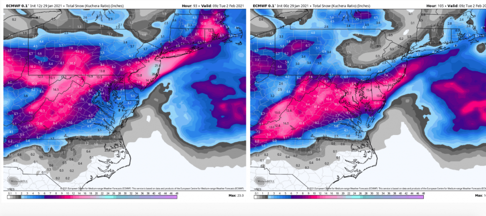
-
Central PA - Winter 2020/2021
Itstrainingtime replied to MAG5035's topic in Upstate New York/Pennsylvania
I just want that perturbation coming SE out of New England to relax and retreat. We need that to happen to end up really happy...


