Itstrainingtime
-
Posts
21,562 -
Joined
-
Last visited
Content Type
Profiles
Blogs
Forums
American Weather
Media Demo
Store
Gallery
Everything posted by Itstrainingtime
-

Central PA - Fall 2021
Itstrainingtime replied to canderson's topic in Upstate New York/Pennsylvania
Love 3:30 games - 7.5 hours to party and relax in the fields before the game, still gets you home at a somewhat decent time tomorrow night. -
Central PA - Fall 2021
Itstrainingtime replied to canderson's topic in Upstate New York/Pennsylvania
That graph I posted from the CDC website is specific to Covid. -
Central PA - Fall 2021
Itstrainingtime replied to canderson's topic in Upstate New York/Pennsylvania
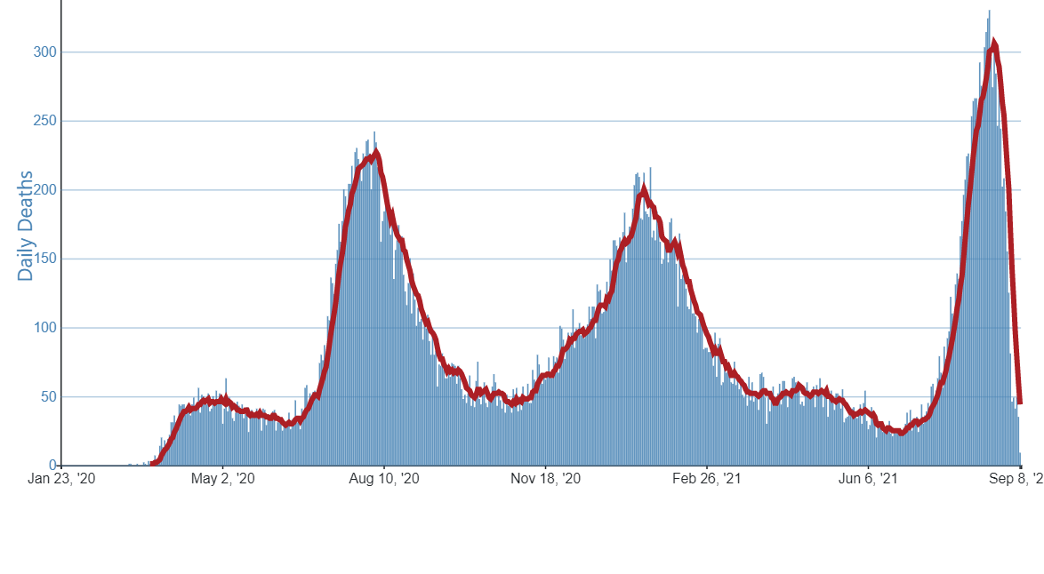
Here is the CDC's graph for deaths in the state of Florida. It looks like both cases and deaths are crashing quickly now.
-
Central PA - Fall 2021
Itstrainingtime replied to canderson's topic in Upstate New York/Pennsylvania
If the winds subside this evening I think we make a run at the 40s. Regardless, it's stellar out there! -
Central PA - Fall 2021
Itstrainingtime replied to canderson's topic in Upstate New York/Pennsylvania
First as in ever? Have an awesome time! PSU dubbs itself as the "Greatest Show in College Football" and while it won't be electric like a whiteout night game against OSU, it's going to be a great time nonetheless. Soak it all in and enjoy! -
Central PA - Fall 2021
Itstrainingtime replied to canderson's topic in Upstate New York/Pennsylvania
My low was 57.2 Looks like a great stretch of weather coming up. -
Central PA - Fall 2021
Itstrainingtime replied to canderson's topic in Upstate New York/Pennsylvania
That's pretty incredible. Pretty good game so far... -
Central PA - Fall 2021
Itstrainingtime replied to canderson's topic in Upstate New York/Pennsylvania
Picked up .04" this afternoon. I've been mowing twice a week for some time now. -
Central PA - Fall 2021
Itstrainingtime replied to canderson's topic in Upstate New York/Pennsylvania
PAZ036-064-092200- Adams PA-Franklin PA- 533 PM EDT Thu Sep 9 2021 ...A strong thunderstorm will impact portions of Adams and southeastern Franklin Counties through 600 PM EDT... At 533 PM EDT, Doppler radar was tracking a strong thunderstorm over Marion, moving east at 35 mph. HAZARD...Wind gusts up to 50 mph and pea size hail. SOURCE...Radar indicated. IMPACT...Gusty winds could knock down tree limbs and blow around unsecured objects. Minor damage to outdoor objects is possible. Locations impacted include... Chambersburg, Waynesboro, Gettysburg, Greencastle, Hampton, Guilford, Littlestown, Carroll Valley, Fayetteville, Wayne Heights, Bonneauville, New Oxford, Mont Alto, Lake Heritage, Rouzerville, Marion, Cashtown, Aspers, Orrtanna and Maugansville. -
Central PA - Fall 2021
Itstrainingtime replied to canderson's topic in Upstate New York/Pennsylvania
Bingo. -
Central PA - Fall 2021
Itstrainingtime replied to canderson's topic in Upstate New York/Pennsylvania
Oh, I wasn't arguing that for a second. My list of teams is merely all the teams/schools I despise enough to specifically root against them at pretty much every opportunity. Sure, if Dallas is playing Baltimore and a Raven win would eliminate the Steelers, I'm on the Jerrywagon. -
Central PA - Fall 2021
Itstrainingtime replied to canderson's topic in Upstate New York/Pennsylvania
It was sort of a painful process to put myself through... But then again...it's Dallas. -
Central PA - Fall 2021
Itstrainingtime replied to canderson's topic in Upstate New York/Pennsylvania
Cowboys, Eagles, Patriots, Phillies, Yankees, Rangers, Lakers, Celtics, Buckeyes, Wolverines, Crimson Tide would all cause me to do so. -
Central PA - Fall 2021
Itstrainingtime replied to canderson's topic in Upstate New York/Pennsylvania
I'm ready for a big warmup - already tired of my wife complaining about the AC being set at a temp above the air temp outside. -
Central PA - Fall 2021
Itstrainingtime replied to canderson's topic in Upstate New York/Pennsylvania
Did someone say the 'Boys were playing tonight? Time for a new picture! (I'll change each week going forward...guess to what it'll be) -
Central PA - Fall 2021
Itstrainingtime replied to canderson's topic in Upstate New York/Pennsylvania
Yep...let's get it cranking while we maximize the low sun angle. It's pack retention... -
Central PA - Fall 2021
Itstrainingtime replied to canderson's topic in Upstate New York/Pennsylvania
Numbers Thursday: Rain yesterday: 1.42" Rain since midnight: .56" Storm total: 1.98" Rainfall since 9/1: 9.37" -
Central PA - Fall 2021
Itstrainingtime replied to canderson's topic in Upstate New York/Pennsylvania
1.42" here, rain is increasing in intensity once again. -
Central PA - Fall 2021
Itstrainingtime replied to canderson's topic in Upstate New York/Pennsylvania
1.05" and counting. It's dumping! -
Central PA - Fall 2021
Itstrainingtime replied to canderson's topic in Upstate New York/Pennsylvania
Nothing will help the Eagles this year... -
Central PA - Fall 2021
Itstrainingtime replied to canderson's topic in Upstate New York/Pennsylvania
Severe Thunderstorm Watch: Adams, York and Lancaster until midnight. -
Central PA - Fall 2021
Itstrainingtime replied to canderson's topic in Upstate New York/Pennsylvania
Yes, thank you! -
Central PA - Fall 2021
Itstrainingtime replied to canderson's topic in Upstate New York/Pennsylvania
Ha, I didn't take it that you were questioning me - to be honest, I'VE been questioning the readings that I've been posting. It's nice to see that areas around me are representative of my station...but man, there have been times this summer where I've been like "well, this post is going to raise some eyebrows" -
Central PA - Fall 2021
Itstrainingtime replied to canderson's topic in Upstate New York/Pennsylvania
There has been a remarkable difference this summer - 45 days above 90 here, several days in August that were above 95. I recalibrated my station after it needed new parts...I have to believe it's accurate as I've been spot on with the Wunderground stations around me. Other odd thing is that I'm SW of Harrisburg, and on most of the hot days the wind direction has been S or SW...coming from the opposite direction of Harrisburg from my location. (mostly blowing straight from the total boondocks of daxx-land in East Prospect) -
Central PA - Fall 2021
Itstrainingtime replied to canderson's topic in Upstate New York/Pennsylvania
Trust me, where I live is much more rural than Palmyra...at least in the town of Palmyra itself. I'm not in an urban area in any way.