Itstrainingtime
-
Posts
21,594 -
Joined
-
Last visited
Content Type
Profiles
Blogs
Forums
American Weather
Media Demo
Store
Gallery
Everything posted by Itstrainingtime
-

Central Pa. Summer 2024
Itstrainingtime replied to mahantango#1's topic in Upstate New York/Pennsylvania
Just down the road, I'm at 91 for Wednesday! -
Central Pa. Summer 2024
Itstrainingtime replied to mahantango#1's topic in Upstate New York/Pennsylvania
Yep, they lowered me to 91-92 until the end of the week. Highest is Friday at 97. -
Central Pa. Summer 2024
Itstrainingtime replied to mahantango#1's topic in Upstate New York/Pennsylvania
B E A R S Bears Bears Bears! -
Central Pa. Summer 2024
Itstrainingtime replied to mahantango#1's topic in Upstate New York/Pennsylvania
Blizz begging for his Excessive Heat Warning while Steve wants temps in the 80s - interesting times we live in... -
Central Pa. Summer 2024
Itstrainingtime replied to mahantango#1's topic in Upstate New York/Pennsylvania
@Bubbler86 - have fun at the game this evening and enjoy the Troegs and soft pretzel. And don't be driving your Firebird to the game... -
Central Pa. Summer 2024
Itstrainingtime replied to mahantango#1's topic in Upstate New York/Pennsylvania
CTP lowered my high temps next week by a few degrees - 94 or 95 every day starting Tuesday. -
Central Pa. Summer 2024
Itstrainingtime replied to mahantango#1's topic in Upstate New York/Pennsylvania
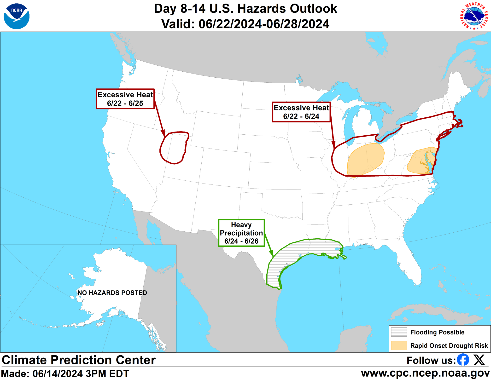
Rapid drought onset just below us.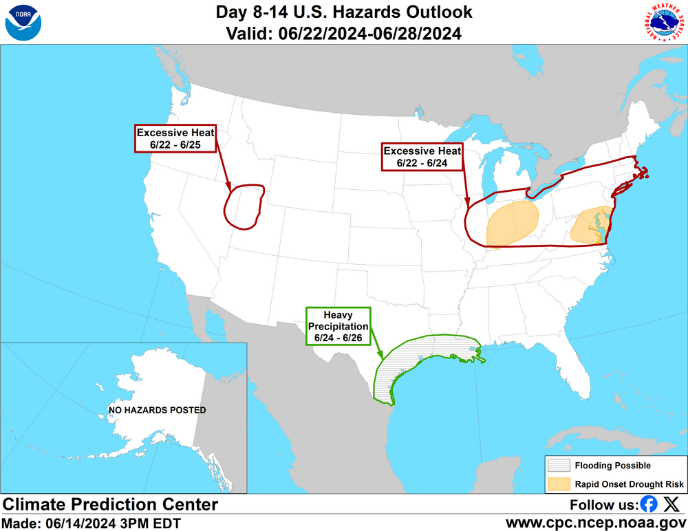
-
Central Pa. Summer 2024
Itstrainingtime replied to mahantango#1's topic in Upstate New York/Pennsylvania
-
Central Pa. Summer 2024
Itstrainingtime replied to mahantango#1's topic in Upstate New York/Pennsylvania
MU with a lengthy write up yesterday on the upcoming week - uh, yeah...if I'm reading correctly he's on board with hot weather: Unfortunately, a heatwave of epic proportions will overtake the Central and Eastern States next week. Millions of residents across more than a dozen states will bake under oppressive heat and humidity for the entire week and into the following weekend. Temperatures will soar to record-challenging or record-breaking levels in multiple states on at least 2 or 3 days during the long-duration sizzlefest (see below). This will end up being the first official heatwave.. defined as 3 or more consecutive days with highs temperatures of 90°F or higher.. of 2024 and could exceed the last one (Labor Day Weekend 2023) in terms of humidity and heat indices. The potential exists for several days in a row with highs in the mid-to-upper 90s and heat indices of 100°F or more across the Lower Susquehanna Valley. It's not out of the question that high temperatures themselves reach 100-102°F in spots next Friday-Sunday. The aforementioned high pressure system will shift into the western Atlantic by Monday and essentially "camp out" there for the rest of the week. On its backside, broad, southwesterly flow originating from the Gulf of Mexico and western Atlantic will draw progressively hotter and more humid air northward into the Central and Eastern States. Monday won't be "dangerously hot" yet with highs around 90°F and dewpoints only in the low-to-mid 60s, but the same cannot be said from Tuesday into the following weekend. A sprawling, Jet Stream ridge, or "heat dome," will expand, amplify, and engulf a huge portion of the United States by the middle of the week and be in no hurry to disappear. It often takes several days and multiple disturbances or cold fronts along the ridge's periphery to cause it to weaken and ultimately break down. This case will be no exception, so I am currently unable to pinpoint which day the heatwave will actually end. Not that anyone wants to hear this, but it most likely won't be until sometime during the week of June 24th. Anyhow, the large-scale subsidence, or sinking motion, beneath the Jet Stream ridge will cause the air to compress, dry out, and heat up at a very fast rate (see below). Our recent stretch of dry weather will only make matters worse and support higher afternoon temperatures. Evaporation is a cooling process, so high temperatures are often tempered by a few degrees if the ground is abnormally wet. When the ground is dry, the opposite holds true. Without much moisture to evaporate from the ground, there is no process by which to slow the rate of warming, and temperatures often reach or exceed expectations. Thus, I would be foolish to rule out 100-degree temperatures at this distance. The last 100-degree day at Millersville occurred on July 7, 2012, so the argument could be made that we are long overdue.. I'll provide day-to-day details of expected high temperatures, dewpoints, and heat indices on Monday and Tuesday. However, like I mentioned above, high temperatures will likely be in the mid 90s from Tuesday-Thursday and could peak in the upper 90s or low 100s from Friday-Sunday. Dewpoints during the heatwave should primarily be in the 60s but may climb into the low 70s on a couple of days. With the ridge in control, shower and thunderstorm chances will essentially be non-existent, and clouds may even be hard to come by. So yes, "scorching sunshine" will only add to the misery. There won't be much relief from the heat at night, either. With dewpoints in the 60s and 70s, overnight lows will only bottom out around 70°F and could hold in the mid-to-upper 70s in urban areas, especially from Thursday night-Saturday night. During the day, heat indices should be around the century mark from Tuesday-Thursday and could very well reach 110°F at some point next weekend. With the excruciating heat and humidity right around the corner, it will be essentially to practice heat safety tips and know the warning signs of heat exhaustion and heatstroke. In order to mitigate the risk of developing heat-related illnesses, avoid alcohol and drink plenty of water and other beverages high in electrolytes. Wear loose-fitting/light-colored clothing and take frequent breaks from the heat in the shade or, preferably, an air-conditioned room or building. As far as diet, avoid salty/dehydrating foods. Instead, eat plenty of fruits and vegetables high in electrolytes, minerals, and nutrients. Applying a cool compress around your neck at times can also help your body from overheating. Never leave pets or children unattended in a vehicle! On a 90-degree day, the internal temperature of a car can reach 120°F in just 20 minutes and 135°F in an hour. Imagine how fast that would occur on a 100-degree day.. The impending heatwave should be taken seriously and is not a joking matter. Locally, it may end up being the longest and most extreme since July 2011. There have been substantial heatwaves in the Northeast and mid-Atlantic States over the past decade, but none of them have had the potential of the upcoming one. See the graphic below for warning signs, symptoms, and appropriate responses to heat exhaustion and heatstroke. I'll leave it at that for now. Enjoy Father's Day Weekend, but make sure you're able to be in a place that has air conditioning next week. It will be a necessity.. -- Elliott -
Central Pa. Summer 2024
Itstrainingtime replied to mahantango#1's topic in Upstate New York/Pennsylvania
Correct - or a desert. -
Central Pa. Summer 2024
Itstrainingtime replied to mahantango#1's topic in Upstate New York/Pennsylvania
Yankees will have something to say about that. Could be a Philly - NYY 15th anniversary series. -
Central Pa. Summer 2024
Itstrainingtime replied to mahantango#1's topic in Upstate New York/Pennsylvania
I drought. Swing in a miss yesterday with nothing but more dry weather in front of me. Congrats someone else. No mowing in my future. The champ is about to be dethroned. -
Central Pa. Summer 2024
Itstrainingtime replied to mahantango#1's topic in Upstate New York/Pennsylvania
Shame - game has had great pitching, solid defense, a couple of huge timely hits, and 2 reviews of plays at the plate, one for each team in the 10th. Playoff atmosphere. -
Central Pa. Summer 2024
Itstrainingtime replied to mahantango#1's topic in Upstate New York/Pennsylvania
Epic game unfolding in Baltimore. Baseball at it's best. -
Central Pa. Summer 2024
Itstrainingtime replied to mahantango#1's topic in Upstate New York/Pennsylvania
Not a freaking drop here. Sun is out. Enjoy. -
Central Pa. Summer 2024
Itstrainingtime replied to mahantango#1's topic in Upstate New York/Pennsylvania
And almost all of what the HRRR had yesterday was along the southern tier. -
Central Pa. Summer 2024
Itstrainingtime replied to mahantango#1's topic in Upstate New York/Pennsylvania
One thing that I never...never do is go to a concession stand during a game. Doesn't matter the sport or the level, if I'm getting food it will be upon entering the venue. I will not miss any portion of the game. -
Central Pa. Summer 2024
Itstrainingtime replied to mahantango#1's topic in Upstate New York/Pennsylvania
@Bubbler86 around 11am, I checked the ticket availability for the Bears game tonight. It looked roughly 2000 seats left? I just checked again and now there's no more than a few hundred. Should end up with a sellout or very close to it. Sunday's tickets are also moving fast. -
Central Pa. Summer 2024
Itstrainingtime replied to mahantango#1's topic in Upstate New York/Pennsylvania
@Atomixwx that storm to your west has had a big time hail core for a long time now. On mobile and can't tell if your in the path or not. -
Central Pa. Summer 2024
Itstrainingtime replied to mahantango#1's topic in Upstate New York/Pennsylvania
Point and click for Bradford - 96 on Tuesday and 97 for Wednesday... -
Central Pa. Summer 2024
Itstrainingtime replied to mahantango#1's topic in Upstate New York/Pennsylvania
There is a stat today for everything - last night the Red Sox became the first team in years to hit at least 7 fair balls with an exit velocity over 100 mph in the first 2 innings. Even in the 1st the outs were loud. -
Central Pa. Summer 2024
Itstrainingtime replied to mahantango#1's topic in Upstate New York/Pennsylvania
MU already at 84 - here in Maytown it's a chilly 82. -
Central Pa. Summer 2024
Itstrainingtime replied to mahantango#1's topic in Upstate New York/Pennsylvania
LOL, I just realized the dude is wearing an Embiid jersey. I don't need to look any further to understand the point of this. -
Central Pa. Summer 2024
Itstrainingtime replied to mahantango#1's topic in Upstate New York/Pennsylvania
That's what made that "not getting swept in a series" streak by the Orioles truly remarkable. Losing streaks are inevitable in baseball no matter how good a team is. -
Central Pa. Summer 2024
Itstrainingtime replied to mahantango#1's topic in Upstate New York/Pennsylvania
Pretty sure you'll get well this weekend.