

dWave
-
Posts
1,903 -
Joined
-
Last visited
Content Type
Profiles
Blogs
Forums
American Weather
Media Demo
Store
Gallery
Posts posted by dWave
-
-
7 minutes ago, donsutherland1 said:
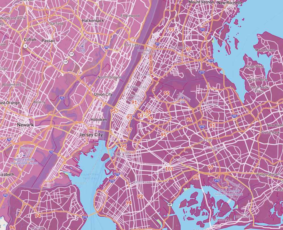
The New York Downtown station (KJRB) has reached 105. I am not confident in its reliability. Having said that, parts of the City beyond JFK Airport did reach 100° based on the NYC Micronet.
Dunno if exactly 105 is accurate, but I know it get quite hot around there. Its one of the few places in Manhattan that gets unobstructed sunshine all day. When a sea breeze off the water there isnt a factor it's typically hotter than Midtown, which gets relatively little sun to the surface throughout the day.
-
 1
1
-
-
30 minutes ago, LibertyBell said:
wow where is that 101? Ozone Park?
Brownsville BK...103 now.
Tremont is 101
i'm a mile away from there at 100
-
1
-
-
-
1 minute ago, Sundog said:
Wait I think you're talking about the Astoria one. I know that area, I used to go bowling there a while back haha.
The Corona one is well SE of that, somewhere near 50th Ave and 103rd street judging by the placement of the temperature on the map. The webcam shows it facing a regular street.
oh my bad lol. I thought you said Astoria for some reason
-
1
-
-
18 minutes ago, Sundog said:
You would think it would be at least as good if not better that the Ambient Stations I use for temps around the area.
I've been trying to pinpoint the Corona one for days using satellite, streetview, building colors in the webcam, etc. I can't seem to find it.
That's a tough one because its on the Con Ed grounds. You wont be able to see a street view etc. Looks like its on what would be a continuation of 31 St, just north of 20th Av, in the Con Ed facility. Or you could say a continuation of 19th Ave into Con Ed near the end of that small inlet of water from the East River.
-
12 hours ago, Sundog said:
Is there a way to get the exact location for the NYC micronet stations? Like cross streets?
The state run ones, NY Mesonet, are at CUNY colleges. Manhattan is at Hunter College, Queens at Queens College, Brooklyn at Brooklyn College, Bronx at Lehman College and Staten Island at College of Staten Island. For the NYC Micronet ones I don't know if an exact address listed anywhere. I usually can get pretty specific by zooming in on the map, plus using the live camera shot. It will also say which direction the camera is pointing. Comparing it to Google Maps satellite view would help too. Some are obvious if you have a familiarity with the area. I know Tremont/Van Nest is at the Con Ed facility off Bronxdale Ave next to Parkchester.
-
Sitting at 98 / 75.
Nyc micronet little over a mile away at 99.
-
90, dew 76 heat index 101 at 9:15am
Low was 80
-
 1
1
-
-
Stifling out. 87 dew 74.
-
Steady temp at 90 dew 73
-
28 minutes ago, Wxoutlooksblog said:
There's no storm east of here right now. All the action is well to our south. Storms that were developing to our nw are falling apart as the high pressure ridge builds in. But time is short for Central Park to get from their 1PM temperature of 78 to their expected high of 92. I don't think they're going to make it.
WX/PT
I think in general it's possible but very difficult at the Park. Places like LGA can have a high at 6 pm or so. Some updated hourly forecasts have low 90s at 7pm. The Park doesn't do late day highs well though. Wet soil and foliage plus evening sun drops below the trees and does reach there. Sometimes Central Park will keep pace with other area obs then flatline in mid afternoon while everyone else not under a sea breeze keeps climbing.
-
1
-
-
19 minutes ago, Sundog said:
This renegade storm circled in red is producing clouds moving to the SE and is prolonging the cloud cover across the NYC area
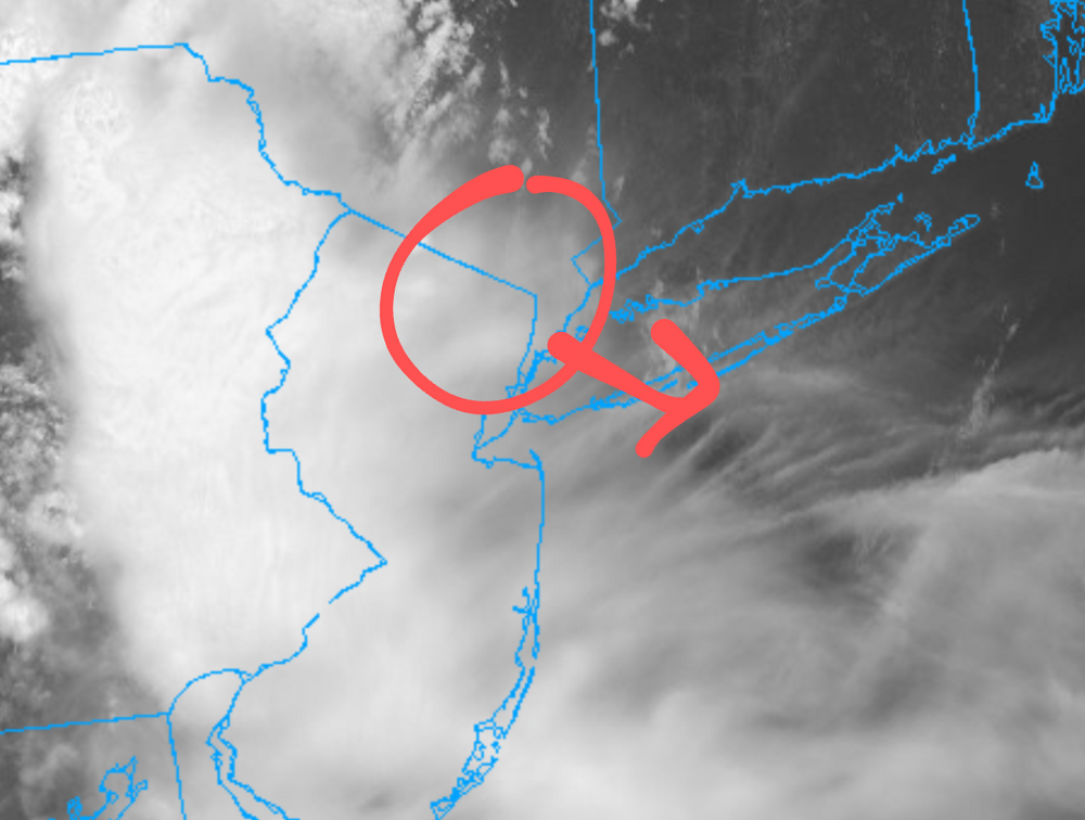
So that explains why after some breaks of sun, I thought we turned the corner but the then clouds started increasing again and now it's a thick overcast again.
NWS hourly forecasts still say 95F for right now. 15 - 20 degree bust is wild.
-
4
-
-
Back up to 80 dew 72 with occasional brightening skies. Basically back up to the morning low before the rain
-
2
-
-
50 minutes ago, winterwarlock said:
It's not a nuisance for literally tens of thousands of pent up beach goers who made plans to
The economic impact for many will start to take a toll if this weekend rain pattern continues. An unexpected shower or T storm isn't that surprising in summer, but an extended organized batch of rain with no warning does suck, and seems rare in the warmer months.
Also people had the plan to do some outdoor stuff early while the heat is at least tolerable. Now getting t storms moving through.
Watch those NYC temps. Central Park underachieves temp wise even more when its wet there, compared to out in the open where it dries out faster.
-
1
-
-
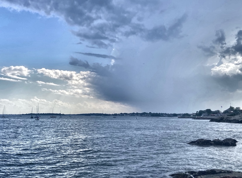
Where is this rain coming from? Doesn't look like just a brief shower either. Looks like hours of light to mod rain ahead.
-
Upton issued Extreme Heat Watch issued for most of the area, eastern Suffolk is left out.
Is that different for an Excessive Heat Watch/Warning? Or did they just change the terminology?
NWS has 100 forecasted for Mon and Tues. At least point and click in the Bx, a lot of Queens
-
Someone got struck by lightning in Central Park near E 96th St
-
2
-
-
43 minutes ago, donsutherland1 said:
Approaching thunderstorm a short time ago. It was rapidly falling apart.
Came through strong at Glen Island Juneteenth event. Pouring, lots of thunder, brief break and rain again.
-
2
-
-
Darkness looking toward Hunts Point and LGA. Looks like it moving more east of instead of NE now.
City Island and boats on the Sound might get it good.
-
3 minutes ago, steve392 said:
Looks like another one behind it. Storms is cool but I wish they held off till later. A lot of people relying on a dry early to mid afternoon today.
-
Hit 90, now down to 86 dew 77 with partial sun and rain, a few claps of thunder but the worst seemed to fizzle out.
-
1
-
-
87 / 73 feels like 95
-
2 hours ago, bluewave said:
Prior to the NWS leaving 30 Rock back in the early 1990s, they really did a great job maintaining the site at the castle. I actually got to meet the forecasters on a trip to the office back in the 80s. Granted they had plenty of struggles with vandals especially during the 1970s since the equipment was out in the open. So I guess they made the decision that hiding the equipment under the trees in 1995 was the way to go. Even though it has resulted in the high temperatures running 2° to perhaps 4° cooler on warm sunny days then they did when the ASOS was further from the trees. This is why the NWS didn’t like substituting LGA for NYC when they were waiting for the new equipment to arrive in the park. Since they are quoted in this NYT article stating that LGA used to run cooler than NYC in those days when the trees weren’t an issue. This is the opposite of what has happened in the last 30 years.
https://www.nytimes.com/1977/07/22/archives/vandals-in-central-park-forcing-weather-service-to-seek-new-site.htmlWhen the devices at the castle are not functioning, the Weather Service substitutes readings from La Guardia Airport. But Mr. Gibson said those readings do not really reflect conditions in the city, because they may be several degrees cooler in summer or warmer in winter than those in Central Park.
I suspected they partly like it being hidden because of potential vandals or curious people tampering with it. Also for historical purposes they don't want to mess with it even though they know it's not an ideal setup. There a reason most cities official readings are at airports and not in the heart of the city. It's very difficult to find a spot that meet NWS standards in the downtown of any major city. If you did it'd be prime real estate and someone would snatch it up for a more profitable use.
I think it also on the media to portray an accurate image of urban conditions and not just regurgitate whatever Central Park says. More NYC residents are closer to the airport sites anyway, and thats what weather apps will show.
From my time in DC I noticed they tend to give a closer to equal respect to all the offical reporting stations.
-
78 dew 71 start to the day

Newark (interiors of NJ/se NYS/CT) Sun-Wed June 22-25 possibly hottest 3-4 day period this year (2025) with 2-4 100F+ days, possibly hottest June daily. NYC probably one 100 deg. HI exceeds 105 interior M-T June 23-24.
in New York City Metro
Posted
Wait for the...."New York City has not reached 100F in xx years."
They need to be specific.."Central Park" hasn't, not the city of New York.