

dWave
-
Posts
1,848 -
Joined
-
Last visited
Content Type
Profiles
Blogs
Forums
American Weather
Media Demo
Store
Gallery
Posts posted by dWave
-
-
11 minutes ago, Snow88 said:
Holy shit its pouring cats and dogs
I have never seen it rain this hard in a long time
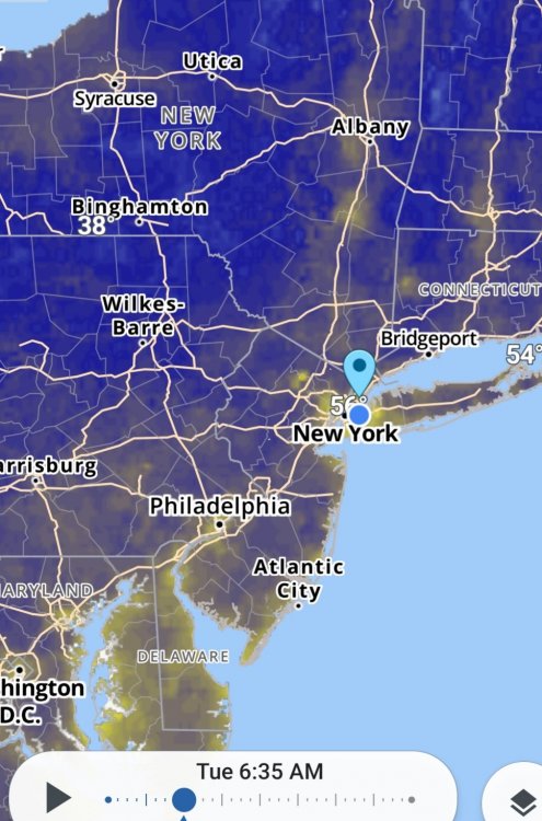
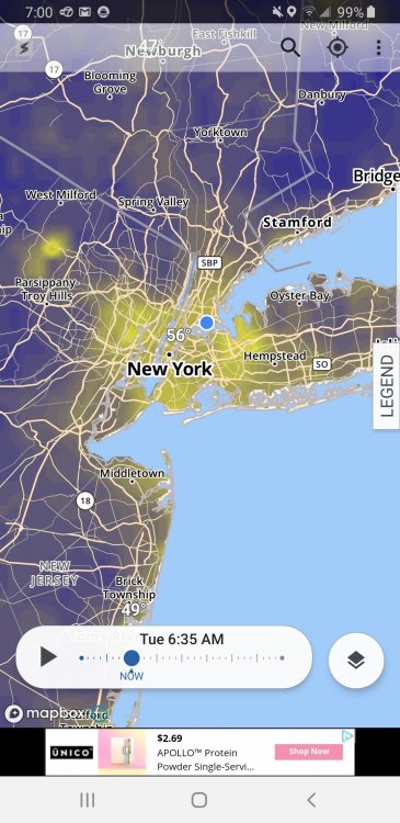
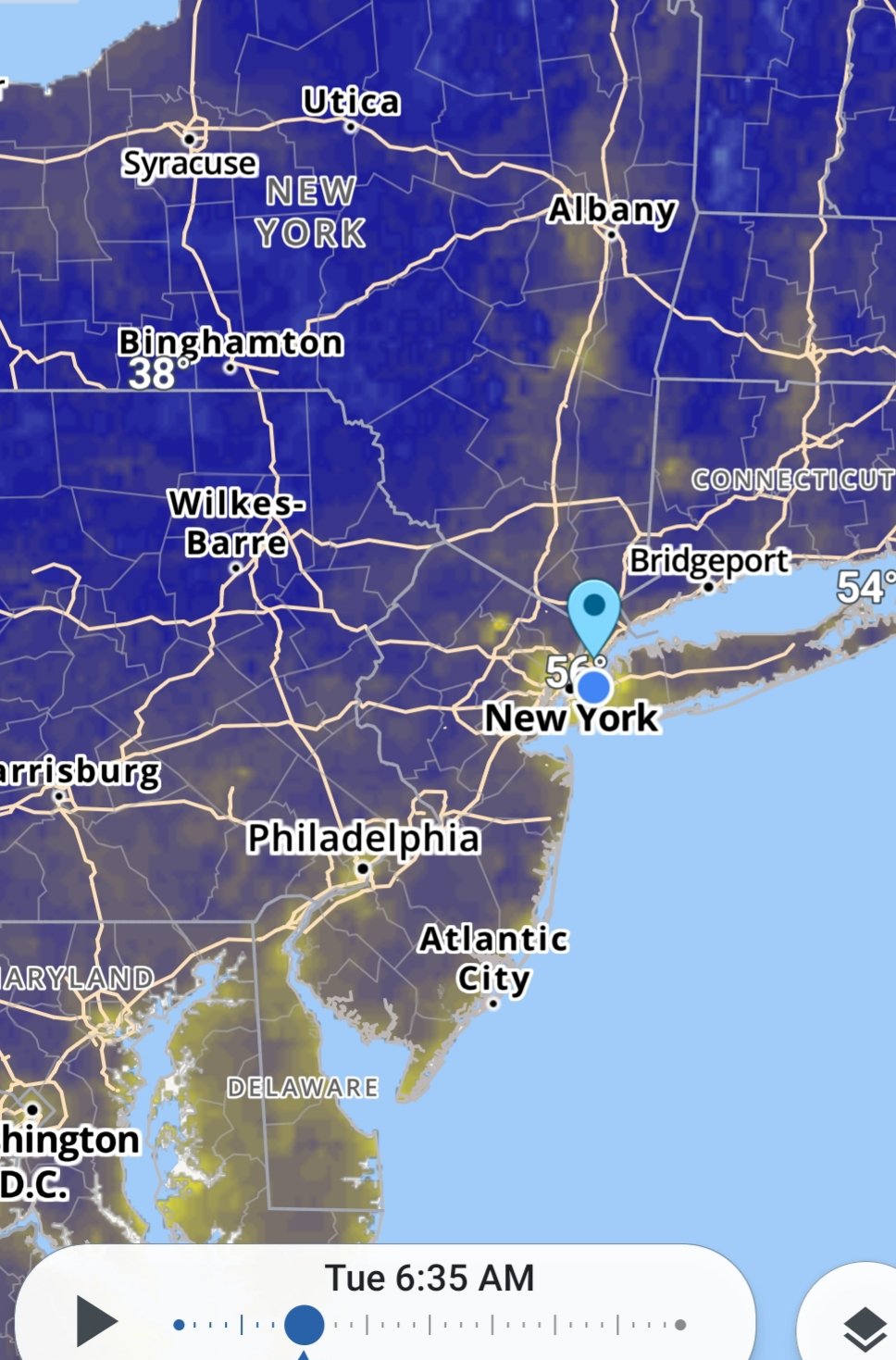
Epic deluge in lower Manhattan. Umbrellas basically useless.
-
 1
1
-
-
1 hour ago, allgame830 said:
So where is the warm front currently. What about up in the Lower Hudson Valley?
Manhattan mesonet shot up to 78/72. So at least at NYC I guess. Hazy sun trying to break thru too
-
It looks like it's trying to brighten outside looking south. Also the fog has lifted above 30th fl window in lower manhattan and I can see outside again.
-
30 minutes ago, Rtd208 said:
I actually would have thought the dew point and humidity would have started to rise by now but it has stayed pretty low this afternoon making for a nice day.
Current temp 84/DP 53/RH 32%
Was thinking the same thing. Strong SW wind all day and dews still in the 40s. 81, DP 44 here.. It's probably an unpopular opinion but I find it a little too dry to me. Esp for allergy and asthma purposes. Doesnt have to be 70s but I'd like to reach a point where dews stay basically 50+ for the season.
-
Bright sunshine and very windy. Howling downtown. Clouds are racing across the sky, interesting to see but was that forecasted?
-
8 hours ago, Juliancolton said:
The 00z Albany balloon was within a degree of minimum climo 850mb temp, and radiating conditions are close to ideal. 44/42 at the moment. If sunrise were an hour or two later, I'd have some serious frost concerns. As it stands, not difficult to envision getting down to 37-38 and putting the brakes on plant vigor for the next week.
Shout out to the UHI for taking care of that problem..
-
Lots of thunder and lightning for a while but only led to a brief period of light rain or drizzle. Slid just south and east over south bx, qns, nassau north shore.
-
Severe t storm warning NE NJ, NYC western Nassau.
Those ch 7 alerts are on point while watching NBA finals
-
8 minutes ago, dmillz25 said:
That impressive. We talk about it but it seems hail rarely materializes within nyc.
I got partly cloudy skies and temp down to 79.
-
1 hour ago, bluewave said:
Second sea breeze pop up storm over the North Shore.

I see it from the bx looking toward the Sound...plus T storms just nw over Riverdale/Yonkers and just to the south over LGA. So far here in a small calm spot wit clouds and sun. Ominous skies all around except straight overhead.
-
33 minutes ago, winterwx21 said:
HRRR is similar. Both models have the storms missing us to the south today. Will be interesting to see if those models are right, because SPC has the whole area in a slight risk.
I was about to ask around what time should I expect rain/storms to reach NYC? Should I be asking "if" instead? I'm going to be outside all day am hoping it stays dry as late as possible..like post 5pm.
-
A little disappointing how much clouds and haze there is today
-
1
-
-
6 hours ago, bluewave said:
This is one of the few times we have seen something resembling an urban cooling departure island in NYC. Areas all around NYC will finish warmer than normal in May. The cool departures were limited to NYC, LGA, and JFK. It could be a first.
EWR...+0.7
NYC...-0.4
LGA....-0.6
JFK....-0.3
HPN...+0.8
ISP.....+1.0
New Brunswick...+1.7
That's interesting. All the clouds, rain has temps, esp lows temps, more uniform. NYC has higher norms though. Cloudy nights are a bigger + for the suburbs. EWR probably spent a little extra time just outside of marine influences too for an added boost.
-
2 hours ago, Brian5671 said:
These backdoor fronts once they lock in are hard to dislodge. Upton has 66 here today-we have not budged out of the mid 50's. Same ol story every time-the front gets further S and W than modeled and it's stuck in the 50's for days...
One would think these back door fronts would become much less stubborn by this point.
I live by the when in doubt, side with the backdoor cold front motto. (For NYC and points N&E ) Usually by mid May or so I have much less faith in the bdcf's staying power.
-
Been in the 50s all morn. 59 now with a light NE wind after a low of 56
-
4 minutes ago, hooralph said:
Watching from the bleachers here on the UWS. All going to our south
Yeah in the bx had a brief light shower now its dry, with few rumbles of thunder. Watching lots of lightning on cams of lower Manhattan, NY harbor
-
8 minutes ago, TriPol said:
Looks like a literal train of thunderstorms headed to NYC.
Lower Manhattan BK, SI look in line of fire
-
Some downpours in the bx, nothing close to severe though. Temp down to 78.
-
89. Feels good to me with dropping Dew point.
-
6 hours ago, NJwx85 said:
Tornado Warning
DCC001-MDC033-VAC013-510-232015-
/O.NEW.KLWX.TO.W.0019.190523T1947Z-190523T2015Z/

BULLETIN - EAS ACTIVATION REQUESTED
Tornado Warning
National Weather Service Baltimore MD/Washington DC
347 PM EDT Thu May 23 2019

The National Weather Service in Sterling Virginia has issued a

* Tornado Warning for...
  The District of Columbia...
  West central Prince Georges County in central Maryland...
  Southeastern Arlington County in northern Virginia...
  The north central City of Alexandria in northern Virginia...

* Until 415 PM EDT.

* At 346 PM EDT, a severe thunderstorm capable of producing a tornado
  was located over US Capitol, or over Nationals Park, moving east at
  40 mph.

  HAZARD...Tornado.

  SOURCE...Radar indicated rotation.

  IMPACT...For those in the direct path of a tornado touchdown,
           flying debris will be dangerous to those caught without
           shelter. Damage to roofs, siding, and windows may occur.
           Mobile homes may be damaged or destroyed. Tree damage is
           likely.

* This dangerous storm will be near...
  Coral Hills and Bladensburg around 350 PM EDT.

Other locations impacted by this tornadic thunderstorm include Rock
Creek, Suitland-Silver Hill, Brentwood, The Mall, Catholic
University, National Arboretum, Chillum, North Brentwood, National
Zoo and Bolling Air Force.

PRECAUTIONARY/PREPAREDNESS ACTIONS...

TAKE COVER NOW! Move to a basement or an interior room on the lowest
floor of a sturdy building. Avoid windows. If you are outdoors, in a
mobile home, or in a vehicle, move to the closest substantial shelter
and protect yourself from flying debris.
wow dont see that everyday. DCA reported wind gust to 68 mph, including 3 separate gusts to 67 over the course of a few mins.
https://twitter.com/MAllen703/status/1131667407150428163
Meanwhile, I saw some lightening strikes from high rise in lower Manhattan. Pretty dramatic from that perspective. I left soon after, took the train, got back above ground 30 mins later and it was partial sunshine. No idea if it actually rained, but didn't really look like it. Doesn't sound like I missed much.
-
87 but less humid now.
Also..word is there's a great white shark in the LI Sound. Not out at the east end either but in the western end off of Greenwich.
-
1
-
-
25 minutes ago, Cfa said:
77/70.
First 70 degree dew point. First 80 within reach.
Yeah 78/70 here
-
Any early ideas of what Memorial day wkend has in store? It went from hot to brutal in DC today. Ppl on trains coming from points north wearing jackets looking insane. Will some of this get unleashed to us?
-
5 hours ago, BombsAway1288 said:
It really is night and day down there compared to NYC/BOS. They always, at least recently, seem to have super warm and above average temps on any given day after April 1st, even in late March sometimes. Not to mention the constant screw jobs they get in the winter while the NE gets buried.
Too much warmth year round for me.
Glad we don't live there.
Yeah I lived there for a little while and one of the biggest difference to me was how consistant spring warmth settles in much faster and with staying power. Mid 70s in the middle of this week is considered a significant cool down here now. It helps being 100 miles from the still cold Atlantic.


Summer 2019 Banter Thread
in New York City Metro
Posted
I noticed alot this past weekend walking thru parkchester in the bx.