

dWave
-
Posts
1,864 -
Joined
-
Last visited
Content Type
Profiles
Blogs
Forums
American Weather
Media Demo
Store
Gallery
Everything posted by dWave
-
July 2020 General Discussions & Observations Thread
dWave replied to Rtd208's topic in New York City Metro
Downpour starts to move away but it keeping filling in behind it. Didnt realize storms would be moving south to north today..or SSW to NNE. Antidotely, I remember t storms coming from the south as some of the most prolific rain makers. -
July 2020 General Discussions & Observations Thread
dWave replied to Rtd208's topic in New York City Metro
Pouring..a little thunder. Looks sunny a few blocks east. 82 dew 77 -
July 2020 General Discussions & Observations Thread
dWave replied to Rtd208's topic in New York City Metro
Very humid, reminds me of a Miami morning. 81 dew 76 -
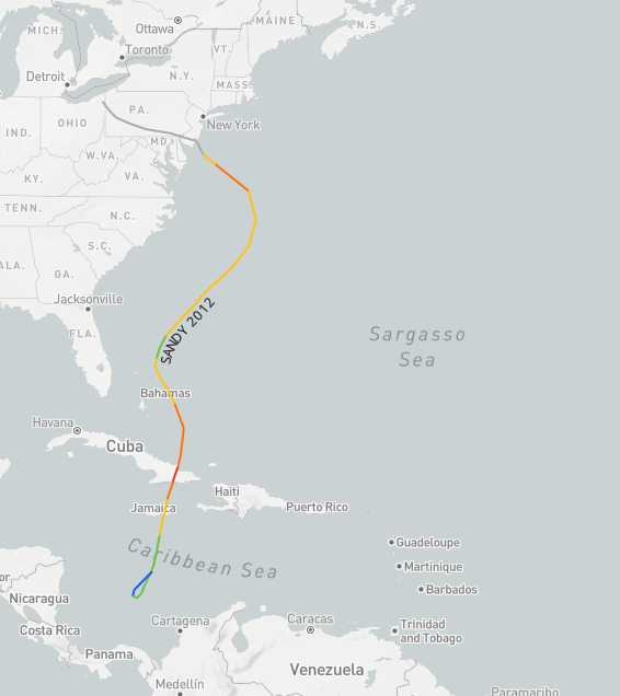
yup, Jamaica then Cuba https://coast.noaa.gov/hurricanes/#map=4/32/-80
-
NY Mesonets in the 5 boros showing mostly 2"+ then a big drop off (for now?) in the Bronx and points north less than an inch. had a few short bursts of mod to heavy rain, but mostly light showers, however more recently getting consistently mod to heavy rain
-
July 2020 General Discussions & Observations Thread
dWave replied to Rtd208's topic in New York City Metro
High 91, now 86/72 -
July 2020 General Discussions & Observations Thread
dWave replied to Rtd208's topic in New York City Metro
Partly Cloudy/hazy, 84 dew 74 HI 91. Heat Advisory issued today and tomorrow for NYC. -
July 2020 General Discussions & Observations Thread
dWave replied to Rtd208's topic in New York City Metro
77, dew 71. A few moments of brightening skies but generally an overcast breezy day. -
Northern part of cell filling back in. Windy a few pings of hail starting. BULLETIN - IMMEDIATE BROADCAST REQUESTED Severe Thunderstorm Warning National Weather Service New York NY 439 PM EDT Mon Jul 6 2020 The National Weather Service in Upton NY has issued a * Severe Thunderstorm Warning for... Eastern Bergen County in northeastern New Jersey... Southern Westchester County in southeastern New York... Queens County in southeastern New York... Bronx County in southeastern New York... Rockland County in southeastern New York... New York (Manhattan) County in southeastern New York... * Until 545 PM EDT. * At 439 PM EDT, a severe thunderstorm was located over Riverdale, or near Bergenfield, moving east at 5 mph. HAZARD...Ping pong ball size hail and 60 mph wind gusts. SOURCE...Radar indicated. IMPACT...People and animals outdoors will be injured. Expect hail damage to roofs, siding, windows, and vehicles. Expect wind damage to trees and power lines. * Locations impacted include... Yonkers, New Rochelle, White Plains, Bergenfield, Paramus, Rye, Tarrytown, Dobbs Ferry, Nyack, Rfk Bridge, Flushing, Throgs Neck Bridge, Sleepy Hollow, Mott Haven and Tappan. PRECAUTIONARY/PREPAREDNESS ACTIONS... For your protection move to an interior room on the lowest floor of a building.
-
Looks like its gonna fizzle out over me. Maybe catch the edge of it. . Bulk of it maybe aimed toward midtown, lower Manhattan. What is going on in Hoboken, Union City, to Clifton? Looks like its been stationary for 45 mins+, getting blasted.
-
It is crawling. Its been 2 mins away for the last half hr. Just getting some light rain now.
-
Lot of thunder now. BULLETIN - IMMEDIATE BROADCAST REQUESTED Severe Thunderstorm Warning National Weather Service New York NY 331 PM EDT Mon Jul 6 2020 The National Weather Service in Upton NY has issued a * Severe Thunderstorm Warning for... Hudson County in northeastern New Jersey... Southeastern Bergen County in northeastern New Jersey... Queens County in southeastern New York... Bronx County in southeastern New York... New York (Manhattan) County in southeastern New York... * Until 415 PM EDT. * At 331 PM EDT, a severe thunderstorm was located over Hackensack, moving southeast at 10 mph. HAZARD...60 mph wind gusts and quarter size hail. SOURCE...Radar indicated. IMPACT...Minor hail damage to vehicles is possible. Expect wind damage to trees and power lines. * This severe thunderstorm will be near... Hackensack and Bergenfield around 335 PM EDT. Teterboro around 345 PM EDT. Englewood around 350 PM EDT. Ridgefield and Fort Lee around 405 PM EDT. New York and Mott Haven around 415 PM EDT. PRECAUTIONARY/PREPAREDNESS ACTIONS... For your protection move to an interior room on the lowest floor of a building. Torrential rainfall is occurring with this storm, and may lead to flash flooding. Do not drive your vehicle through flooded roadways.
-
increasing clouds now from a storm just east of Paramus. Trying to get into upper Manhattan/Bronx/Southern Westchester
-
July 2020 General Discussions & Observations Thread
dWave replied to Rtd208's topic in New York City Metro
Park is slightly ahead of LGA and EWR too. Closer to the Sound, a NE wind usually keep me cooler than the Park . Still 90s though either way. -
July 2020 General Discussions & Observations Thread
dWave replied to Rtd208's topic in New York City Metro
90 dew 62 Central Park is 92 -
July 2020 General Discussions & Observations Thread
dWave replied to Rtd208's topic in New York City Metro
Low was 77, now 89 -
It really did..but its sounded like that for over a month now so it kind of wore out its welcome for me tbh.
-
July 2020 General Discussions & Observations Thread
dWave replied to Rtd208's topic in New York City Metro
Makes sense, I never gave it much thought. I always think about upswellings effect in water temps. Dew point shot up last hr. Low 50s to around 70. Temp down to 88. Dry mid 90s felt better. Actual 95 more tolerable than heat index of 95. -
July 2020 General Discussions & Observations Thread
dWave replied to Rtd208's topic in New York City Metro
I went to Robert Moses, fairly warm (around 80?) and quite humid down there. Could feel the heat more in western Nassau and a wall of heat that put AC to the test north of the LIE into the BX. 95 here but a dew point 54. On a side note I cant remember ever seen waters so turquoise around here, alot of ppl were marveling at it. -
July 2020 General Discussions & Observations Thread
dWave replied to Rtd208's topic in New York City Metro
The cool 96 summer was like the historic 95-96 winter refusing to fully let go. -
July 2020 General Discussions & Observations Thread
dWave replied to Rtd208's topic in New York City Metro
After the rain down to 77..dew 76 Park got to 90. -
July 2020 General Discussions & Observations Thread
dWave replied to Rtd208's topic in New York City Metro
missing the heavy stuff..mostly cloudy drizzle/light rain 90 after high of 92. -
July 2020 General Discussions & Observations Thread
dWave replied to Rtd208's topic in New York City Metro
90 here -
July 2020 General Discussions & Observations Thread
dWave replied to Rtd208's topic in New York City Metro
Some breaks of hazy sun now 88/71 -
July 2020 General Discussions & Observations Thread
dWave replied to Rtd208's topic in New York City Metro
Cloudy..temps rising slowly, 86 dew 70.
