

dWave
-
Posts
1,864 -
Joined
-
Last visited
Content Type
Profiles
Blogs
Forums
American Weather
Media Demo
Store
Gallery
Everything posted by dWave
-
Oh wow..woke up to a dusting of snow, perhaps more than a dusting. On cars, trees, grassy surfaces.
-
25..a little bit of a shock to the system. Had to pull out the real deal coat
-
30 here. Several consecutive hrs below freezing ahead for the first time. Finally gonna get a hard freeze. The remaining flowers etc had a usually long run, their end has finally come.
-
Ha..I have these planted outside and yday it dawned on me..what are they still doing here?? They aren't exactly healthy but still holding on to lots of flowers. Usually they are shriveled up sticks by now. While it has occasionally reached the freezing point we haven't had a hard freeze yet with none imminent. It's more lack of sun slowly ending the growing season then cold temps bringing an abrupt end.
-
Come to think of it, March avg snowfall usually is greater than Dec anyway. I remember when the normal Dec snow was around 2.5", then the next normals update jumped to under 5", thanks to more of the snowy 2000s in the mix. March avg I always remember being around 5". I don't know what the 90-2020 Dec avgs are by month. The difference between Dec and Mar has become more pronounced now, but I never look at Dec as reliably snowy. It can get decent snow but it feels equally unsurprising to get very little or a trace.
-
65 dew 60. Up 10 in an hr.
-
It was always going to be a late high temp, sometime after sunset. Temps here have taken off since 4pm, mid 50s to low 60s in 20 mins
-
Had some flashes of lightning late morning with a brief downpour.
-
Ok now it's mainly snow ❄ I got this Weatherflow Tempest PWS so now I can start putting it to the test.. https://www.wunderground.com/dashboard/pws/KNYNEWYO1578 https://tempestwx.com/station/63889
-
36 and rain..perhaps a few wet snowflakes if you squint enough.
-
That's true..those fractions of an inch do get lost if you don't measure quickly. It was worse then when the zookeeper was doing the measurements. That's a benefit of using airports since its a 24/7 operation and even if they care less about meteorology, they have aviation reasons as motivation to keep track of snowfall etc. No one's going out to measure 0.2" in a park at 3am unless you're really passionate about the weather, or you had to be there anyway.
-
97-98 was the virtually snowless winter until the late March 5" surprise storm, depriving us of the least snowiest season on record. The 0.5" seemed right to me. I had no idea LGA recorded a couple inches. Under such marginal conditions maybe LGA got under a heavy snow band allowing some acclumation or bringing down enough cold for a brief change to snow at some point. The Park can be bad, but 0.5" was a good representation of that winter in the city. I remember seeing no snow acclumation until the late March storm..which melted in the March sun by sunset, and a hot end to March followed if I remember right. That was around the time I started to give up on the city/coast being a snowy place. I took it as the price paid to the snow gods for the epic 95-96 season. Then the 2000s came and everything flipped lol
-
Beautiful Dec day, Sunny, 50 calm wind
-
Moderate to occasionally heavy snow in lower Manhattan
-
I've always suspected that is a factor. If it was out in the open I'm sure someone would mess with it just because. You still can now, its just not very noticeable unless you are looking for it.
-
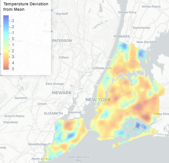
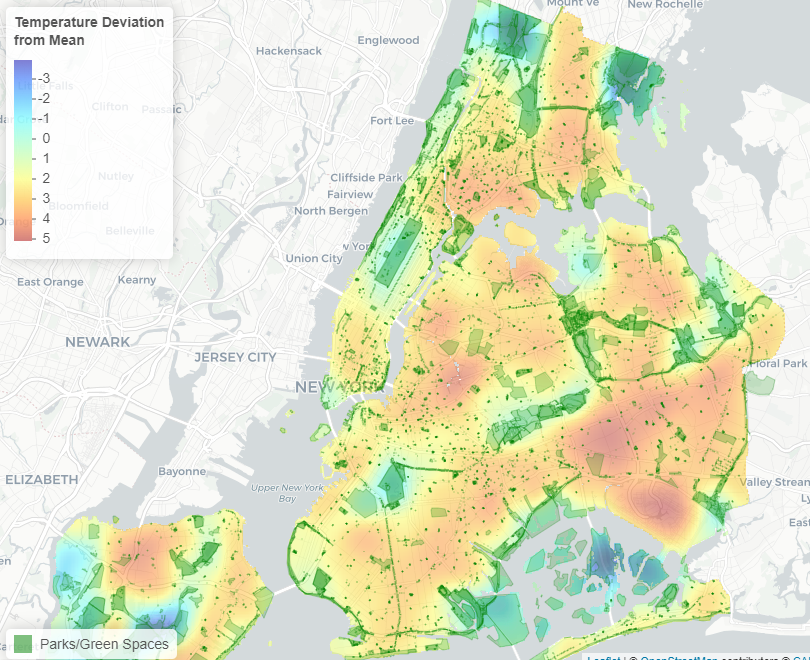
Mapped UHI shows Central Park ( or any large park) isn't a great representation of the day to day experience in NYC. Being in an open field instead of directly under a canopy of trees would help some at least. Manhattan in general looks the coolest on average, at least in the daytime. Particularly Midtown and Lower Manhattan, thanks to extensive shade from high rises. "Using satellite data from the US Geological Survey’s Landsat 8 satellite, the New York City Council’s Data Operations Unit put together a map of how temperature varies across the city..." https://council.nyc.gov/data/heat/ Matched up with parks highlighted. Largest NYC parks: Pelham Bay (1st), Greenbelt, SI (2nd), Van Cortlandt (3rd) are the coolest places, as expected.
-
Freeze warning this am..holding steady at 33. Coldest night so far
-
I saw somewhere it's considered a marine heat wave now off the northeast coast. They concluded this marine heat wave was a significant factor in the record rain and flooding in the Ida remnants event.
-
I thought it'd get a few degrees colder here. Wind seem calm..ideal for most places but I've heard it been said calm winds isn't always the best in the most urbanized areas for coldest temps since a breeze can act like a fan on the UHI. Sat am first shot at freezing?
-
41 after a low of 39. No frost. Tomatoes, peppers etc live on
-
37..tied coldest of the season so far. Frost advisory tomorrow am for Bronx, Manhattan, Hudson County, NJ, Southern Nassau
-
Wow maybe my first real hail storm within NYC I've seen. Not just occasional pellets but heavy hailstorm with some acclumation
-
Some very strong winds howling in lower Manhattan. Didn't expect winds that strong. Workout for the day walking against it. With it alot of temps in the upper 60s now
-
45 after a low of 40. Finally can see some significant foliage in the 5 boros, but still below 50% overall. Look like real explosion of color as close as north half of Yonkers or so.
-
Patchy frost at best type morning in or immediately near NYC. Saw frost on cars parked along Bronx Park E along/near NY Botanical Garden. A block away from the park, nothing. Drove through Pelham Bay Park and saw some patchy frost, then into dtwn New Rochelle where I saw none. If you're block is leafy enough it pushes you over the edge

