

MattPetrulli
-
Posts
1,728 -
Joined
-
Last visited
Content Type
Profiles
Blogs
Forums
American Weather
Media Demo
Store
Gallery
Everything posted by MattPetrulli
-
 MRX updated their snow map I actually think they're being too aggressive, at least for Sevier County.
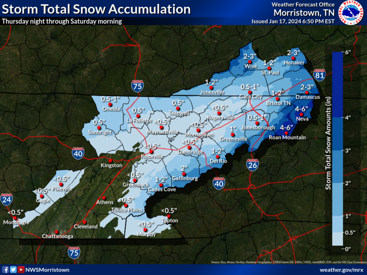
- 372 replies
-
- 5
-

-
- cold
- arctic blast
- (and 1 more)
-
Once again Euro vs GFS. GFS is kind of the outlier here, only model in its camp is the ICON. The rest are just a slushy mix for most of the valley.
- 372 replies
-
- 1
-
-
- cold
- arctic blast
- (and 1 more)
-
January 15th-17th 2024 Arctic Blast/Snow Event
MattPetrulli replied to John1122's topic in Tennessee Valley
Still a mix here. One of the most disappointing forecast busts, if not the most I have ever experienced. -
January 15th-17th 2024 Arctic Blast/Snow Event
MattPetrulli replied to John1122's topic in Tennessee Valley
I hope this band coming in gives an inch or 2 -
January 15th-17th 2024 Arctic Blast/Snow Event
MattPetrulli replied to John1122's topic in Tennessee Valley
Heavy snow in Sevierville finally. Maybe too little too late though. -
January 15th-17th 2024 Arctic Blast/Snow Event
MattPetrulli replied to John1122's topic in Tennessee Valley
No power and a cold rain in Sevierville . -
January 15th-17th 2024 Arctic Blast/Snow Event
MattPetrulli replied to John1122's topic in Tennessee Valley
We’ve run into a massive problem in Sevier County.. mixing. HRRR has us being stuck in a mix all day. While it looks like it’s snowing hard on radar here, it’s not. This is extremely disappointing and frustrating if it ends up winning out. . -
January 15th-17th 2024 Arctic Blast/Snow Event
MattPetrulli replied to John1122's topic in Tennessee Valley
Still a bit worried about the warm nose, but if that isn't a problem, I can see Sevier County overperforming. Especially given the HRRR dry bias. -
January 15th-17th 2024 Arctic Blast/Snow Event
MattPetrulli replied to John1122's topic in Tennessee Valley
Well, the warm nose has made a reappearance. -
January 15th-17th 2024 Arctic Blast/Snow Event
MattPetrulli replied to John1122's topic in Tennessee Valley
Lol am I being trolled? EDIT: Showcasing HRRR dry bias -
January 15th-17th 2024 Arctic Blast/Snow Event
MattPetrulli replied to John1122's topic in Tennessee Valley
Really excited about these rates. Hopefully can exceed an inch+ an hour. -
January 15th-17th 2024 Arctic Blast/Snow Event
MattPetrulli replied to John1122's topic in Tennessee Valley
TYS reporting moderate snow with this band, first real band about to come through. -
January 15th-17th 2024 Arctic Blast/Snow Event
MattPetrulli replied to John1122's topic in Tennessee Valley
Classic HRRR dry bias . -
January 15th-17th 2024 Arctic Blast/Snow Event
MattPetrulli replied to John1122's topic in Tennessee Valley
All 00z models including CAMS paste the Valley. Nam family is on an island. Becoming more and more optimistic for a good snow event -
January 15th-17th 2024 Arctic Blast/Snow Event
MattPetrulli replied to John1122's topic in Tennessee Valley
OHX and MRX going conservative on snow totals -
January 15th-17th 2024 Arctic Blast/Snow Event
MattPetrulli replied to John1122's topic in Tennessee Valley
I'm worried about mixing in Sevier County. RGEM, ICON, HRRR, NAM, NAM3K, even the 18z GFS show a possibility of this. Really want a FV3 type of solution with all snow, but am afraid that possibility is beginning to fade. Still a lot of time for change, but after so many disappointing winters/setups, I am greedy for snow. -
January 15th-17th 2024 Arctic Blast/Snow Event
MattPetrulli replied to John1122's topic in Tennessee Valley
-
January 15th-17th 2024 Arctic Blast/Snow Event
MattPetrulli replied to John1122's topic in Tennessee Valley
01z NBM -
January 15th-17th 2024 Arctic Blast/Snow Event
MattPetrulli replied to John1122's topic in Tennessee Valley
We're so back -
December 2023 Mid/Long Term Pattern Discussion: Let it Snow!
MattPetrulli replied to John1122's topic in Tennessee Valley
-
From NWS Morristown The upper ridge and surface high pressure will shift to our east by Monday. Models are still struggling with the details of the complex system that evolves to our west, with the GFS often showing less phasing of the southern stream and northern stream energy, while the Euro has been more on board with the two systems getting in phase and a more vigorous surface low developing. While there is still considerable spread, there is also quite a bit of support among the ensemble members for the stronger solution, and confidence is nudging upward for the possibilty of a significant mountain wave event mainly Monday night into Tuesday as a surface low likely tracks by to our west and northwest and 850 mb flow likely approaches or exceeds 50kt across the mountains from the S and/or SE. Given the ongoing serious drought and the most likely scenario of the rain holding off for at least the first part of the potential high winds, there remains a threat of a period of increased fire danger mainly along and just to the west of the E TN mountains. The wind threat and fire danger threat will continue to be highlighted in the HWO.
-
Winds won't be as strong as Gatlinburg, LLJ probably won't be strong enough. However, it may be on the same level as the Wears Valley fires in 2022. To make things worse, we were not in a drought for the Wears Valley fires, while as we are in a severe drought this time around Then vs now. That being said, a saving grace could be a large precip shield ahead of whatever cold front convection comes through. That may help temper the fire threat a lot. However, if the precip shield does not come through during the day, Monday night-Tuesday will be very scary.
-
2023 Atlantic Hurricane season
MattPetrulli replied to Stormchaserchuck1's topic in Tropical Headquarters
1. Southwestern Caribbean Sea: A broad area of low pressure is forecast to form in the southwestern Caribbean Sea by the middle of next week. Thereafter, environmental conditions appear conducive for gradual development of this system while it meanders in the Caribbean Sea through the latter part of next week. * Formation chance through 48 hours...low...near 0 percent. * Formation chance through 7 days...low...30 percent.

