MattPetrulli
-
Posts
1,728 -
Joined
-
Last visited
Content Type
Profiles
Blogs
Forums
American Weather
Media Demo
Store
Gallery
Everything posted by MattPetrulli
-
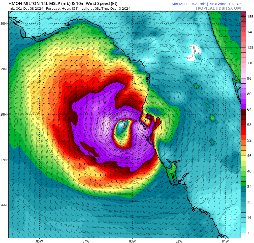
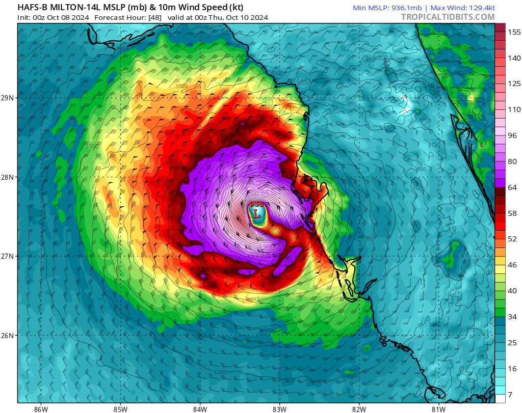
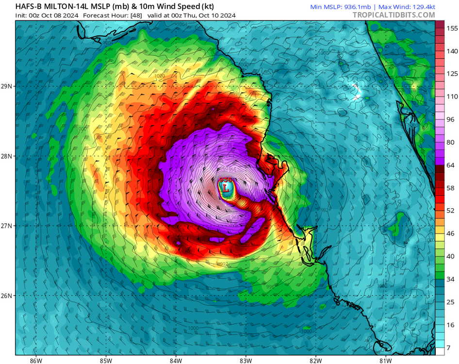
Getting better agreement on track/intensity with 00z hurricane models
-
Yep, kinda similar to Joaquin and the 2015 South Carolina floods
-
What METAR placefile are you using?
-
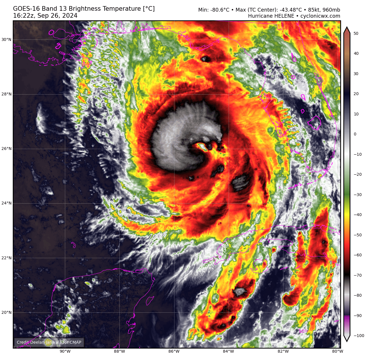
Despite the southern eyewall opening on radar, VDM says its closed. Also, velocities continue to intensify on radar, Helene is still intensifying.
-
SE eyewall has new VHTs going up + eye warming rather rapidly.
-
Looking ever increasingly better, imo think we can get to 120-125 knots at LF. Still several hours left over water.
-
500 PM EDT Thu Sep 26 2024 ...HELENE IS A VERY DANGEROUS AND LARGE MAJOR HURRICANE... ...DAMAGING HURRICANE WINDS AND CATASTROPHIC STORM SURGE EXPECTED TO BEGIN IN THE FLORIDA BIG BEND THIS EVENING... SUMMARY OF 500 PM EDT...2100 UTC...INFORMATION ---------------------------------------------- LOCATION...27.9N 84.6W ABOUT 130 MI...205 KM W OF TAMPA FLORIDA ABOUT 175 MI...280 KM S OF TALLAHASSEE FLORIDA MAXIMUM SUSTAINED WINDS...125 MPH...205 KM/H PRESENT MOVEMENT...NNE OR 25 DEGREES AT 23 MPH...37 KM/H MINIMUM CENTRAL PRESSURE...951 MB...28.09 INCHES
-
...AIR FORCE HURRICANE HUNTERS FIND HELENE A MAJOR HURRICANE... The Air Force Hurricane Hunters found that the maximum sustained winds have increased to near 120 mph (195 km/h). This makes Helene a dangerous category 3 major hurricane. Additional strengthening is expected before Helene makes landfall in the Florida Big Bend this evening. SUMMARY OF 225 PM EDT...1825 UTC...INFORMATION ---------------------------------------------- LOCATION...26.7N 84.9W ABOUT 170 MI...280 KM WSW OF TAMPA FLORIDA ABOUT 205 MI...335 KM S OF APALACHICOLA FLORIDA MAXIMUM SUSTAINED WINDS...120 MPH...195 KM/H PRESENT MOVEMENT...NNE OR 25 DEGREES AT 16 MPH...26 KM/H MINIMUM CENTRAL PRESSURE...959 MB...28.32 INCHES
-
Disagree. We still got 8-ish hours until landfalls and it's already at 95-100 knots. I wouldn't call 115 knots unlikely.
-
FL reduction would support a cat 3 upgrade.
-
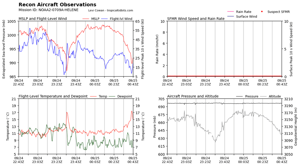
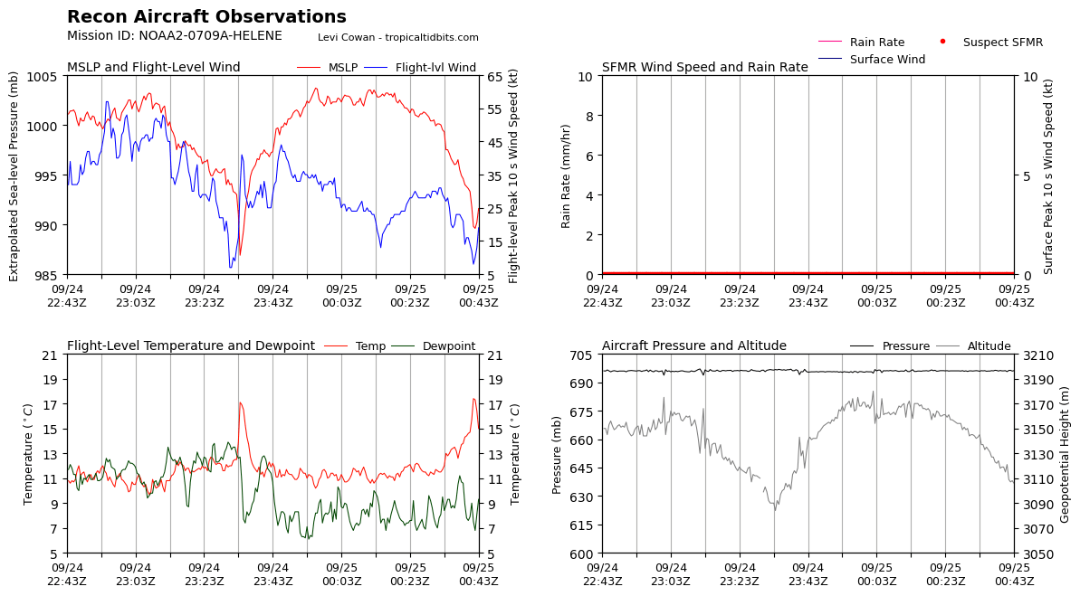
115 Knot FL last pass, 956.6 HPA
-
Eyewall and CDO continue to improve and looking real good now.

-
958.3 extra
-
Dual rotating VHTs on each side now
-
Satellite has been improving with VHTs firing in right quad along with CDO ballooning and cooling

-
It's subsidence from the VHTs
-
Latest VDM is closed eyewall. Off to the races now
-
Thought so too, but NHC is still using the catastrophic wind wording which is used for category 4+ only so I think it's just the forecast point.
-
Kinda getting Ida vibes. Ida kinda struggled/gradually intensified throughout the day before LF with dry air I believe (though this dry air is more significant I think) then exploded over like a 12 hour period. Granted, Ida was smaller than what Helene is/will be, thus exacerbating the rate of intensification. Also Helene has more time than what Ida did at this time.
-
First sign of meaningful intensification all afternoon. May finally be go time, and also while constructing a more proper eyewall, maybe it can construct a CDO.
-
81 knot FL on last pass. We got a hurricane more than likely.
-
78 knot FL would support a 65 knot even 70 knot upgrade.
-
Ah yes, the classic 979 MB tropical storm.
-
Quite the PRE event modeled on GFS for NC/TN/GA. Can't post the GIF but I feel like the flood threat so far inland is going under the radar no pun intended.
-
986 pass earlier probably just from a mesovort. Pressure came up a bit, but this is probably the beginning of core construction given the temperature spike present.