

Amos83
-
Posts
1,034 -
Joined
-
Last visited
Content Type
Profiles
Blogs
Forums
American Weather
Media Demo
Store
Gallery
Everything posted by Amos83
-
Needless to say the FV3 is going to make a name for itself with this storm. We will either never take it seriously again or crown in the new king
-
Looks to me the reason for the warmth is that the low is over New Orleans instead of off the coast. Any adjustment north will push cause the colder air to retreat a bit.
-
It's too early in the season to already be tired of half the posters on here. Gonna be a long winter of model watching
-
you seem pretty confident in that. As unlikely as it may seem I think they are honking the horn to grab the general public's attention that a potentially serious winter storm is headed this way. If they are wrong and it ends up being more ice the public will hopefully still be prepared. People tend to understand the seriousness of large snow accums better than ice accrual forecasts in my opinion. just my two cents
-
interesting, based off this graphic looks like their thinking is that the it is basically all snow from around UNCC and points north and west
-
Woke up and read the Disco out of GSP, all I can say is that I'm officially hyped bow. Can't remember the last time they used such strong wording this far out. Those guys are some of the best Mets in the country
-
yep for sure.... that one really hacked me off and why I'm so gun shy with this one. the type of snow being shown on the models is rare for around here so our caution should be even more warranted this go around. Although which each passing model run it is getting hard to contain the excitement for sure
-
The fact that this is an ensemble mean is absurd. As much as I want to get deliriously excited about this I think we need to remember that we will for sure be dealing with WAA at some point, no way we will get such a juiced up storm and not have it. WAA is very hard to forecast and many times it comes it stronger than anticipated. Having said that it is beautiful to see these runs continue over and over
-
don't jinx it man!
-
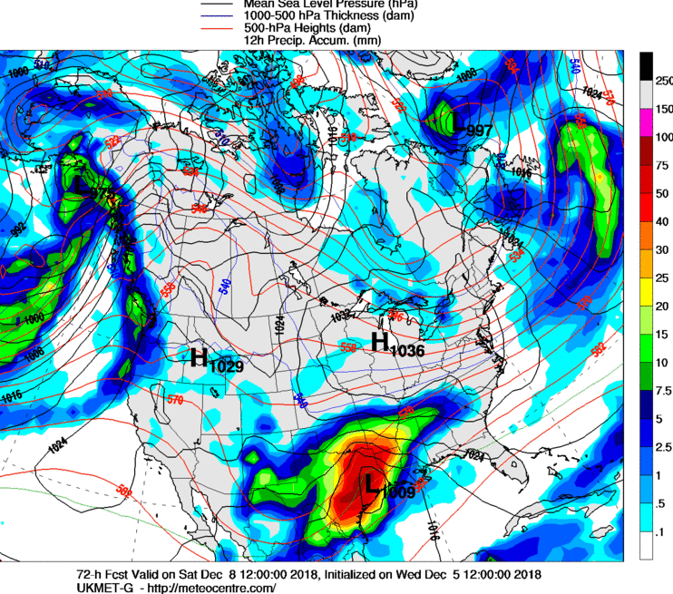
One thing to take note of too, is many times with the super juiced up el nino driven storms precip breaks out way ahead of the main system. UKMET seems to be hinting at it. Notice the finger pointing directly at WSC and WNC. Could mean the precip starts a little sooner
-
As they say, "to get the epic snow you want to be able to smell the rain". Needless to say, this would paralyze the city for a few days
-
This +1000 We are still a little over 3 days from the storm hitting, models are going to continue to oscillate north and south a bit for a while still. Ensembles are still the way to go this far out and they look nice for a very large portion of us. Breath people, you'd think some that have been on here for years would learn their lesson by now.
-
Saw about 5 snow flakes this morning otw to work. So the winter season is already off to an awesome start!
-
yep, many times the Davidson/Mooresville area would have 2x the amount of snow I'd get in Concord. Crazy how just a few miles can make such a difference.
-
I'm off 115 between Davidson and Mooresville. Basically right near Lowe's Corporate office off exit 31 on 77. Hopefully the entire CLT area can cash in with this one. Too many good posters on here from the area
-
As long as we can keep the low just on the coast or slightly off it we should do really well with this. It is going to be a monster QPF producer and the CAD will hopefully trend a bit stronger as we get closer (more like what the NAM is starting to show). Glad I moved from east of 85 over to Mooresville, might payoff big time for this one.
-
In my opinion NAM typically does pretty well with thermal profiles. GFS and EURO typically play catch up with CAD setups and trend cooler/colder as the event gets closer. Doesn't always work out that way but usually the NAM does better sniffing out the strength of the CAD before the others do. It has been said before and is a concern for me is the cold source to our northeast will be stale which will probably not lead to a super strong CAD in my opinion.
-
I am not too concerned on the 850s being shown by the Euro yet... typically it doesn't catch on to the strength of the CAD until we get closer, bigger pieces are what we should be concentrating on this far out (as WOW mentioned).
-
Driving back from Destin and have passed 40 or more power crews heading up 85 in South Carolina. Ive seen creaa from Georgia, Alabama, And Mississippi so far. God bless those guys... they are going to some long days ahead of them
-
My #1 rule for winter storms never fails..... NEVER count on the cold air making over the mountains in time. If the cold isn't already here and the source of CAA is west of the mountains I'm screwed.
-

The December to Remember 7th-8th blue turd winter threat thread.
Amos83 replied to lilj4425's topic in Southeastern States
Seems like that is the norm. I remember very painfully on the last even seeing WOW talk about how much it was snowing in Mooresville while at my house right on 85 in Concord it was raining. painful -
The December to Remember 7th-8th blue turd winter threat thread.
Amos83 replied to lilj4425's topic in Southeastern States
Lol at all the cliff diving over night. All the relative newbies on here need to remember a few things when it comes to snow in the south. #1. Never put your hopes in cold air making it over the mountains in time. Cold chasing moisture never pans out for us east of the mountains. #2. Never trust NAM snow output #3. Be thankful for any winter precipitation in December (it is rare) #4. Don't believe it until the snow actually starts to fall. #5. Don't get into a pissing match with the veteran posters, we have lost way too many really good members of the years. Their valuable posts are missed this time of year. Bonus for me with this storm, I've been able to ID several candidates for the mute button well ahead of real snow chasing season, lol. Enjoy what ever snow falls tomorrow. We are only in early December people. -
LOL at the people already complaining..... most everything looks right on schedule. The early cliff diving happens all the time.
-
Weather References and Newbie Information
Amos83 replied to burgertime's topic in Southeastern States
No mention of the dreaded snow triangle?


