MazooWeather
-
Posts
3,866 -
Joined
-
Last visited
Content Type
Profiles
Blogs
Forums
American Weather
Media Demo
Store
Gallery
Everything posted by MazooWeather
-
Went about 14 hours without power, storm knocked out the main transmission line to Branch and Hillsdale counties.
-
Jackson county says "bet'
-
Have a tornado warned storm moving my way and they haven't even done a local watch extension. Makes no sense.
-
Weird watch gap for NW Ohio/SE Michigan rn, you'd think they'd wanna hurry and issue one considering the storms are like less than an hour out
-
Enhanced expanded again
-

2025 Short Range Severe Weather Discussion
MazooWeather replied to Chicago Storm's topic in Lakes/Ohio Valley
If we get the rare "A national weather service employee reported a tornado" in a warning text we'll know it's you o7 -
March 14-15 Severe Weather Outbreak
MazooWeather replied to MazooWeather's topic in Lakes/Ohio Valley
Genuinely was not expecting to get a watch tonight -
March 14-15 Severe Weather Outbreak
MazooWeather replied to MazooWeather's topic in Lakes/Ohio Valley
Strong tornado near Cushman -
March 14-15 Severe Weather Outbreak
MazooWeather replied to MazooWeather's topic in Lakes/Ohio Valley
Cycled again, massive cc drop -
March 14-15 Severe Weather Outbreak
MazooWeather replied to MazooWeather's topic in Lakes/Ohio Valley
First PDS watch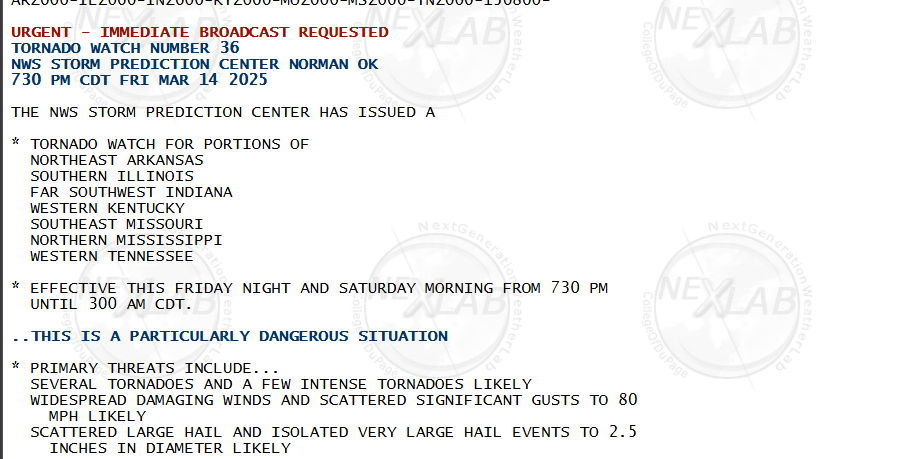
-
March 14-15 Severe Weather Outbreak
MazooWeather replied to MazooWeather's topic in Lakes/Ohio Valley
Things seem to be progressing according to modeling so far, the nighttime timing of the tornadoes tonight is gonna make search and rescue if necessary a pain -
March 14-15 Severe Weather Outbreak
MazooWeather replied to MazooWeather's topic in Lakes/Ohio Valley
Day 2 high risk coming in 10 mins -
Lets get the ball rolling.
-
Next Saturday could be interesting severe wise if everything comes together, GFS has a monster of an MCS from Michigan to the Gulf of Mexico
-
What a comfy rainy morning
-
Winter 2024-25 Medium/Long Range Discussion
MazooWeather replied to michsnowfreak's topic in Lakes/Ohio Valley
Some potential around 144 hours if that massive cyclone keeps shifting west -
Fall/Winter '24 Banter and Complaints Go Here
MazooWeather replied to IWXwx's topic in Lakes/Ohio Valley
The Stormtrack Discord which is ran by conservative Mets shut down discussion on the nws mets getting fired Something something wokeness -
The rain this morning decided to be graupel instead, roads went from fine to slick immediately
-
Winter 2024-25 Medium/Long Range Discussion
MazooWeather replied to michsnowfreak's topic in Lakes/Ohio Valley
Morch -
I'm starting to wonder if I'm even gonna get any snow
-
IWX lowered the WWA to 1 to 4 This is one of the saddest busts ever
-
Going from a foot, to 4-8 to 2-4 so fast is just this winter in a nutshell
-
I guess iwx bought it cause their wwa only is calling for 2 to 4 here lmao
-
Can't make up its mind the model
-
Grr not doing a watch, just extended the wwa