lakeeffectkid383
-
Posts
5,059 -
Joined
-
Last visited
Content Type
Profiles
Blogs
Forums
American Weather
Media Demo
Store
Gallery
Everything posted by lakeeffectkid383
-
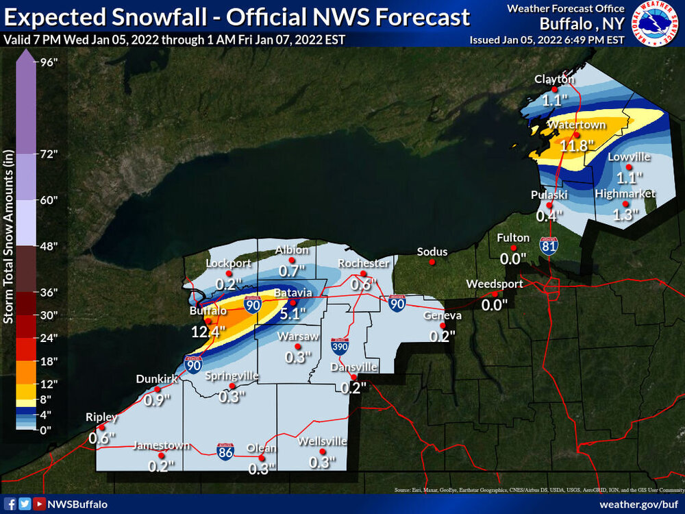
 This map is just bonkers lol. 8-12” here when we’ve had 1/2” , not a chance lol.
 -
Have you hit anything worthwhile? Unfortunately the band looks kinda a mess right now.
-
You may want to set up in Tonawanda by the time you get here lol. That thing is moving north quick. Wonder if it makes it to IAG?
-
Grand Rapids didn’t have 60mph gust.
-
Heavy sunshine here.
-
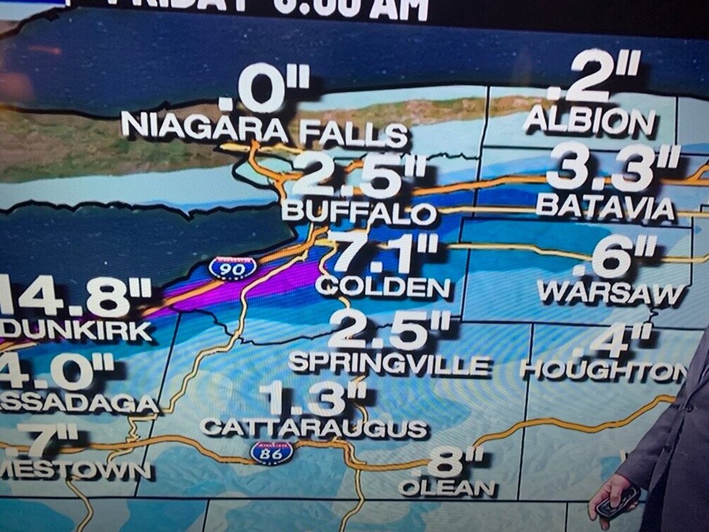
...ERIE COUNTY... DEPEW 9.0 IN 0934 AM 01/06 42.91N/78.70W NWS BUFFALO 6.5 IN 0858 AM 01/06 42.95N/78.72W BUFFALO 5.5 IN 0926 AM 01/06 42.89N/78.86W WALES 2.2 IN 0700 AM 01/06 42.74N/78.59W WEST SENECA 2.8 ENE 2.0 IN 0700 AM 01/06 42.85N/78.70W CHEEKTOWAGA 2.7 NE 2.0 IN 0700 AM 01/06 42.94N/78.72W EAST CONCORD 2.0 IN 0821 AM 01/06 42.56N/78.64W GLENWOOD 1.0 SE 1.5 IN 0700 AM 01/06 42.61N/78.65W BOSTON 2.5 NE 1.2 IN 0700 AM 01/06 42.65N/78.70W CLARENCE CENTER 0.2 ESE 1.0 IN 0645 AM 01/06 43.01N/78.63W HAMBURG 0.4 WSW 0.5 IN 0700 AM 01/06 42.72N/78.84W HAMBURG 2.0 N 0.5 IN 0708 AM 01/06 42.75N/78.83W BOSTON 1.5 NE 0.5 IN 0730 AM 01/06 42.65N/78.72W ORCHARD PARK 0.5 IN 0808 AM 01/06 42.76N/78.75W TONAWANDA 2.1 ESE 0.2 IN 0700 AM 01/06
-
We got jipped in the Southtowns. The winds were WAYY too strong last night and the lake effect over us was weak and shredded apart, once it moved north and winds died down it organized quickly but it definitley underperformed here overnight. I got 1/2” of snow when I had 3-7” forecast…
-
NWS just lowered totals in the warning to 6-12” in the most persistent bands. This ones turning to a dud.
-
Haha it’s 4 am the band looks like total garbage and I got half a dusting. Good thing they closed schools for this today lmao. Never fails, as Ayuud said, every time we have a good set up the winds are too strong. I could tell last night that it was WAY too windy outside to get a good band of snow going (on top of the already limiting factor of low cap height of course lol).
-
Just looked outside and literally said “ HOLY $h!t! , where the street light ?!?.” It’s literally snowing so hard and so windy it’s snowing completely sideways. Could barely see the street light on the corner of my road. It looks like that old weather channel blizzard icon on the bottom “ticker” on the TV. The winds are BEAST tonight.
-
I truly don’t understand how we’re going to get lake effect to form with these winds tonight. It’s absolutely unreal out. I’m having gust shake my house worse then the high wind warnings we had a few weeks ago, it’s fricken insane here right now. I bet we’re gusting close to 60mph if not over. I don’t understand how there’s not a high wind warning let alone an advisory.
-
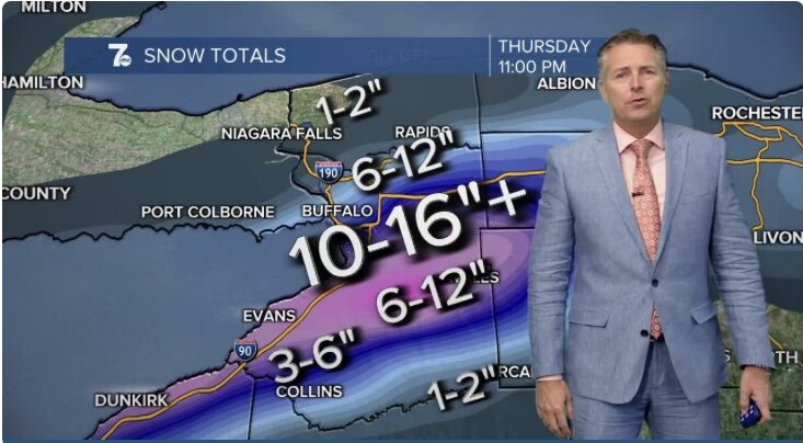
New NWS map really cuts back totals for here, looks more realistic IMO. About 6” here according to the map which is about what I’m expecting here.
-
Dude I’m telling you the winds were CRANKING here like an hour or so ago.
-
Not trying to be a pessimist at all but I don’t understand how lake effect can form when winds are ripping like this. I’m telling you right now there’s 50+ mph gust here easy. It’s insane here right now. Definitley was not expecting winds like this.
-
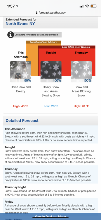
Yes but from what I’ve seen all districts have chosen not to remote learn tomorrow and to just close completely. That was an option but being the first snow day of the year almost all schools declined for remote learning and just gave everyone an old fashioned snow day!
-
Schools are soft as hell now. We were lucky if we were closed by 630 the day of school and that’s if we got BLASTED. Lmao.
-
Winds are CRANKING here. Some flakes in the air here as well. Didn’t even lose all of our “snowpack” either as there’s still a solid inch for the new snow to fall on.
-
think we’d all be happy with this. Spreads the wealth over most of Erie Co.
-
9-17” at my house but I’m not sure I buy it.
-
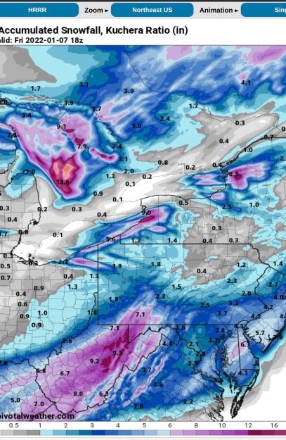
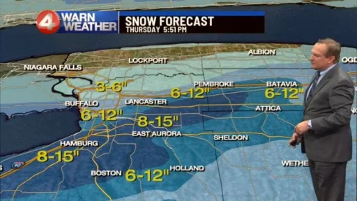
Channel 4 newest model run brings the bullseye even further south. Gonna be a true nowcasting event.
-
12z 3k NAM coming is super weak, almost a non event lmao.
-
These models can’t make up their minds on what they want to do. 00z run had 17” over KBUF.
-
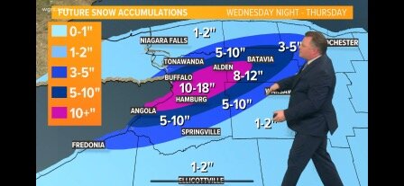
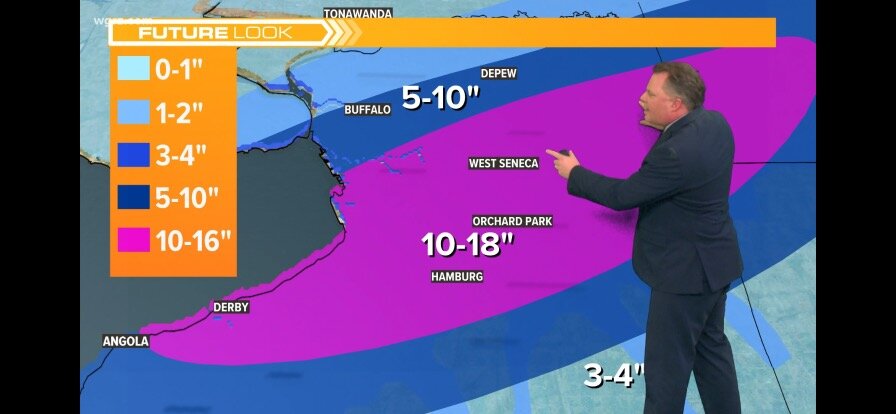
Idk what to think. It’s gotta be super tough to forecast right now. Models have shifted south but history tells us these things come north 5 miles so not sure. I think Mike’s map looks alright, maybe just shift everything north 5 miles.
-
All 3 stations have the bullseye from West Seneca to Hamburg and Derby. Channel 2 & 7 model output puts the heaviest right over BuffaloWeather and I. Literally have no idea what’s gonna happen. Expecting 4-6” total here but hoping for 1’ +